Vitim (river)

Last updated • 2 min readFrom Wikipedia, The Free Encyclopedia
Vitim
Vitim posle Bambuyki.jpg
The Vitim near its tributary Bambuyka
Lena watershed.png
Lena watershed
Native name
Location
Country Russia
Region Buryatia, Irkutsk Oblast, Sakha Republic, Zabaykalsky Krai
Cities Bodaybo, Vitim, Mama, Russia
Physical characteristics
Source 
  locationConfluence of rivers Vitimkan and China, Ikat Range,
Irkutsk Oblast
  elevation1,171 m (3,842 ft)
Mouth Lena
  coordinates
59°27′47″N112°36′05″E / 59.4631°N 112.6013°E / 59.4631; 112.6013
Length1,940 km (1,210 mi)
Basin size225,000 km2 (87,000 sq mi)
Discharge 
  average1,937 m3/s (68,400 cu ft/s)
Basin features
Progression LenaLaptev Sea
Tributaries 
  left Tsipa, Muya, Mamakan, Mama
  right Konda, Karenga, Kalakan, Kalar, Bodaybo
Vitim (river)
Map Vitimrivermap.png
Map

The Vitim (Russian : Витим; Evenki : Витым, Witym; [1] Yakut : Виитим, Viitim[local pronunciation]; [1] Buryat and Mongolian : Витим, Vitim [1] ) is a major tributary of the Lena. Its source is east of Lake Baikal, at the confluence of rivers Vitimkan from the west and China from the east. The Vitim flows first south, bends eastwards and then northward in the Vitim Plateau. Then it flows north through the Stanovoy Highlands and the town of Bodaybo. Including river Vitimkan, its western source, it is 1,978 kilometres (1,229 mi) long, and has a drainage basin of 225,000 square kilometres (87,000 sq mi). [2] [3] [4]

Contents

It is navigable from the Lena to Bodaybo. Upstream, tugs can haul barges as far as the Baikal Amur Mainline (BAM), but this is becoming rare.

The Vitim is an excellent place for adventure rafting, but is rarely visited because of its isolation. Baissa, one of the famous localities of fossil insects is situated on the left bank of the Vitim River.

History

The first Russian to explore the river was probably Maksim Perfilyev in 1639–40, who brought back reports of the upper Amur River. [5] Formerly, because of its swift current, goods were hauled 144 kilometres (89 mi) overland from Chita to Romanovka. There boats were built, floated down the river, and broken up at their destination. This lasted until the late 1940s.

Vitim impact event

The Vitim event occurred in the Vitim River basin near Bodaybo on 25 September 2002. The event was probably caused by a bolide. The event was similar to Tagish Lake.

Course

Vitim.png

Going upstream: Vitim town where the Vitim joins the Lena. Mama and Mama Airport, about 130 kilometres (81 mi) south of Vitim. A muscovite mica mine from 1705 until the late 1930s. Now a small settlement. Mamakan, on a west-flowing stretch 200 kilometres (120 mi) south-southeast of Vitim. In 1963 a 86MW dam on the Mamakan River was completed, one of the first dams built on permafrost. [6] Bodaybo, just upstream, a gold mining center founded in 1864. Upstream, the port of Luzhki was the start of a road to the Lena gold fields. From here upstream the river goes crookedly east and then south. About 240 kilometres (150 mi) upstream from Bodaybo are the Delyun-Uran Rapids [7] and after 140 kilometres (87 mi) more, the Parama Rapids. About 40 kilometres (25 mi) or so upstream, the Vitim is crossed by the Baikal Amur Mainline between Taksimo and Kuanda. Upriver there are more rapids and goldfields. South through the Stanovoy Mountains toward Chita, then west into the Vitim Plateau east of Lake Baikal. [8] The river peaks in June and freezes from November to May.

Tributaries

The main tributaries of the Vitim are, from source to mouth: [2]

See also

Related Research Articles

<span class="mw-page-title-main">Upper Angara</span> River in Russia

The Upper Angara is a river in Buryatia, Siberia to the northeast of Lake Baikal. the third longest river in the Baikal basin. It is 438 kilometres (272 mi) long, and has a drainage basin of 21,400 square kilometres (8,300 sq mi).

<span class="mw-page-title-main">Olyokma</span> River in Yakutia, Russia

The Olyokma is a tributary of the Lena in eastern Siberia.

<span class="mw-page-title-main">Amur–Yakutsk Mainline</span> Partially complete Russian railway

The Amur–Yakutsk Mainline, abbreviated to AYaM, is a partially complete railway in eastern Russia, linking the Trans–Siberian Railway and Baikal–Amur Mainline with the Sakha Republic.

<span class="mw-page-title-main">Northern Muya Range</span> Mountain range in Russia

The Northern Muya Range is a mountain range in Buryatia, Russia, part of the Stanovoy Highlands.

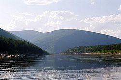
The Mama is a river in Irkutsk Oblast and Buryatia, Russia. It is a left tributary of the Vitim, the second largest in basin area after the Tsipa. The river has a length of 211 kilometres (131 mi) and a drainage basin of 18,900 square kilometres (7,300 sq mi). The total length of the river including the Left Mama is 406 kilometres (252 mi).

<span class="mw-page-title-main">Kodar Mountains</span> Mountain range in Siberia

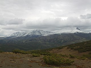
The Kodar Mountains are a mountain range in the Transbaikal region of Siberia, Russia. The name Kodar is derived from "khada", an Evenki word for rock.

<span class="mw-page-title-main">Stanovoy Highlands</span> Mountain range in Russia

The Stanovoy Highlands or Stanovoy Uplands is a mountain range in the Transbaikal region of Siberia, Russia.

<span class="mw-page-title-main">South Siberian Mountains</span> Series of mountain ranges in Russia and Mongolia

The South Siberian Mountains are one of the largest mountain systems of the Russian Federation. The total area of the system of mountain ranges is more than 1.5 million km². The South Siberian Mountains are located in the Siberian and Far Eastern Federal Districts of Russia, as well as partly in Mongolia. The territory of the mountain system is one of the Great Russian Regions.

<span class="mw-page-title-main">Patom Highlands</span>

The Patom Highlands are a mountainous area in Eastern Siberia, Russia. Administratively most of the territory of the uplands is part of Irkutsk Oblast, with a smaller section in northern Zabaykalsky Krai.

<span class="mw-page-title-main">Southern Muya Range</span> Mountain range in Russia

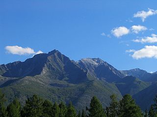
The Southern Muya Range is a mountain range in Buryatia and Zabaykalsky Krai, Russia, part of the Stanovoy Highlands. The highest point of the range is 3,067 m high Muisky Gigant; another important peak is 2363 m high Mount Shaman.

<span class="mw-page-title-main">Kalar Range</span> Mountain range in Zabaykalsky Krai and Amur Oblast, Russia

The Kalar Range is a mountain range in Zabaykalsky Krai and the NW end of Amur Oblast, Russian Federation. The highest point of the range is 2,520 m (8,270 ft) high Skalisty Golets.

<span class="mw-page-title-main">Kalar (river)</span> River in Zabaykalsky Krai, Russia

The Kalar, known as the Levoy Chinoy in its upper section, is a river in Zabaykalsky Krai, southern East Siberia, Russia. It is 511 kilometres (318 mi) long, and has a drainage basin of 17,400 square kilometres (6,700 sq mi). The area through which the river flows is mountainous in most of its length with frequent rapids in the riverbed. The waters are rich in fish, including grayling, lenok, taimen and whitefish, among other species. In the International scale of river difficulty the Kalar is a Class III - IV destination for rafting and kayaking.

<span class="mw-page-title-main">Nyukzha</span> River in East Siberia

The Nyukzha is a river in Amur Oblast and Transbaikalia, East Siberia, Russian Federation. It is the second largest tributary of the Olyokma river in terms of length and area of its basin. The Nyukzha is 583 kilometres (362 mi) long and has a drainage basin of 32,100 square kilometres (12,400 sq mi). There are a number of inhabited places close to the banks of the river, including Ust-Urkima, Lopcha, Chilchi, Ust-Nyukzha, Larba and Yuktali, mostly with a significant Evenk population. A section of the Baikal–Amur Mainline passes along the river valley. The river is a destination for rafting.

<span class="mw-page-title-main">Mamakan (river)</span> River in Irkutsk Oblast, Russia

The Mamakan is a river in Irkutsk Oblast, southern East Siberia, Russia. It is a tributary of the Vitim of the Lena basin. The river is 209 kilometres (130 mi) long, and has a drainage basin of 9,460 square kilometres (3,650 sq mi). There are no settlements by the river, only Mamakan near its mouth by the Vitim.

<span class="mw-page-title-main">Upper Angara Range</span> Mountain range in Russia

The Upper Angara Range is a mountain range in Buryatia and Irkutsk Oblast, Russia, part of the Stanovoy Highlands.

<span class="mw-page-title-main">Ikat Range</span> Mountain range in Buryatia, Russia.

Ikat Range is a mountain range in Buryatia, Russia. It runs in a parallel direction to the Baikal Rift. The range is named after two small rivers sharing the name "Ikat" which have their sources in opposite slopes of the range one is a tributary of the Gargi and the other a tributary of the Vitimkan.

<span class="mw-page-title-main">North Baikal Highlands</span> Mountainous area in Russia

The North Baikal Highlands are a mountainous area in Eastern Siberia, Russia. Administratively the territory of the uplands is part of Buryatia and Irkutsk Oblast.

<span class="mw-page-title-main">Chuya (Lena)</span> River in Russia

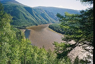
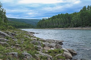
The Chuya, also known as Big Chuya in its last 52 km (32 mi) stretch, is a river in Buryatia and Irkutsk Oblast, Russia. It is the 13th longest tributary of the Lena and the 191st longest river in Russia, with a length of 512 kilometres (318 mi) and a drainage basin area of 18,400 square kilometres (7,100 sq mi).

<span class="mw-page-title-main">Delyun-Uran Range</span> Mountain in Russia

The Delyun-Uran Range is a mountain range in Irkutsk Oblast and Buryatia, Russia, part of the Stanovoy Highlands.

<span class="mw-page-title-main">Kuanda</span> River in southern East Siberia, Russia

The Kuanda, also known as Konda, is a river in Zabaykalsky Krai, southern East Siberia, Russia. It is 196 kilometres (122 mi) long, and has a drainage basin of 6,530 square kilometres (2,520 sq mi).

References

  1. 1 2 3 "KNAB, the Place Names Database of EKI". Eki.ee. Retrieved January 1, 2013.
  2. 1 2 Витим (река в Бурят. АССР), Great Soviet Encyclopedia
  3. "Река ВИТИМin the State Water Register of Russia". textual.ru (in Russian).
  4. "Река ЧИНАin the State Water Register of Russia". textual.ru (in Russian).
  5. Lantzeff, George V., and Richard A. Pierce (1973). Eastward to Empire: Exploration and Conquest on the Russian Open Frontier, to 1750. Montreal: McGill-Queen's U.P.{{cite book}}: CS1 maint: multiple names: authors list (link)
  6. Mamakan reservoir - Water of Russia
  7. Porog Delyun-Uran
  8. Yates and Zvegentzov,'Siberian BAM Guide',2001