Voltaire, North Dakota

Last updated

Voltaire, North Dakota
US Post office in Voltaire North Dakota 10-16-2008.jpg
US Post office in Voltaire
ND McHenry County Voltaire.svg
Location of Voltaire, North Dakota
Coordinates: 48°01′07″N100°50′38″W / 48.01861°N 100.84389°W / 48.01861; -100.84389
CountryUnited States
State North Dakota
County McHenry
Founded1901
Area
[1]
  Total0.49 sq mi (1.26 km2)
  Land0.49 sq mi (1.26 km2)
  Water0.00 sq mi (0.00 km2)
Elevation
[2]
1,591 ft (485 m)
Population
 (2020)
  Total46
  Density94.65/sq mi (36.52/km2)
Time zone UTC-6 (CST)
  Summer (DST) UTC-5 (CDT)
ZIP code
58792
Area code 701
FIPS code 38-82380
GNIS feature ID1036310 [2]

Voltaire is a city in McHenry County, North Dakota, United States. The population was 46 at the 2020 census. [3] It is part of the Minot Micropolitan Statistical Area.

Contents

History

Voltaire was founded in 1901. The city was most likely named after a local pioneer. [4] A post office has been in operation at Voltaire since 1901. [5]

Geography

According to the United States Census Bureau, the city has a total area of 0.40 square miles (1.04 km2), all land. [6]

Demographics

Historical population
CensusPop.Note
1930 61
1940 10165.6%
1950 72−28.7%
1960 70−2.8%
1970 54−22.9%
1980 6520.4%
1990 63−3.1%
2000 51−19.0%
2010 40−21.6%
2020 4615.0%
2021 (est.)44 [7] −4.3%
U.S. Decennial Census [8]
2020 Census [3]

2010 census

As of the census of 2010, there were 40 people in 21 households, including 11 families, in the city. The population density was 100.0 inhabitants per square mile (38.6/km2). There were 22 housing units at an average density of 55.0 per square mile (21.2/km2). The racial makeup of the city was 95.0% White, 2.5% African American, and 2.5% from two or more races.

Of the 21 households 19.0% had children under the age of 18 living with them, 47.6% were married couples living together, 4.8% had a male householder with no wife present, and 47.6% were non-families. 42.9% of households were one person and 23.8% were one person aged 65 or older. The average household size was 1.90 and the average family size was 2.55.

The median age was 49.5 years. 15% of residents were under the age of 18; 2.5% were between the ages of 18 and 24; 22.5% were from 25 to 44; 40% were from 45 to 64; and 20% were 65 or older. The gender makeup of the city was 50.0% male and 50.0% female.

2000 census

As of the census of 2000, there were 51 people in 20 households, including 14 families, in the city. The population density was 125.1 inhabitants per square mile (48.3/km2). There were 21 housing units at an average density of 51.5 per square mile (19.9/km2). The racial makeup of the city was 100.00% White.

Of the 20 households 35.0% had children under the age of 18 living with them, 55.0% were married couples living together, 15.0% had a female householder with no husband present, and 30.0% were non-families. 30.0% of households were one person and 15.0% were one person aged 65 or older. The average household size was 2.55 and the average family size was 3.14.

The age distribution was 31.4% under the age of 18, 2.0% from 18 to 24, 21.6% from 25 to 44, 29.4% from 45 to 64, and 15.7% 65 or older. The median age was 42 years. For every 100 females, there were 96.2 males. For every 100 females age 18 and over, there were 94.4 males.

The median household income was $37,500 and the median family income was $37,500. Males had a median income of $38,750 versus $19,375 for females. The per capita income for the city was $14,854. There were 16.7% of families and 13.0% of the population living below the poverty line, including 26.7% of under eighteens and none of those over 64.

Related Research Articles

<span class="mw-page-title-main">Mahnomen, Minnesota</span> City in Minnesota, United States

Mahnomen is a city in Mahnomen County, Minnesota, United States, along the Wild Rice River. The population was 1,214 at the 2010 census. It is the county seat of Mahnomen County.

<span class="mw-page-title-main">Fifty Lakes, Minnesota</span> City in Minnesota, United States

Fifty Lakes is a city in Crow Wing County, Minnesota, United States. The population was 387 at the 2010 census. It is part of the Brainerd Micropolitan Statistical Area.

<span class="mw-page-title-main">Warwick, North Dakota</span> City in North Dakota, United States

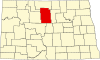
Warwick is a city in Benson County, North Dakota, United States. The population was 55 at the 2020 census. Warwick was founded in 1907.

<span class="mw-page-title-main">Maxbass, North Dakota</span> City in North Dakota, United States

Maxbass is a city in Bottineau County, North Dakota, United States. The population was 89 at the 2020 census. Maxbass was founded in 1905.

<span class="mw-page-title-main">North River, North Dakota</span> City in North Dakota, United States

North River is a city in Cass County, North Dakota, United States. The population was 55 at the 2020 census. North River was founded in 1973. It is a suburb/bedroom community directly adjacent to the city of Fargo.

<span class="mw-page-title-main">Wolford, North Dakota</span> City in North Dakota, United States

Wolford is a city in Pierce County, North Dakota, United States. The population was 43 at the 2020 census. Wolford was founded in 1905.

<span class="mw-page-title-main">Mantador, North Dakota</span> City in North Dakota, United States

Mantador is a city in Richland County, North Dakota, United States. The population was 67 at the 2020 census. Mantador was founded in 1893. It is part of the Wahpeton, ND-MN Micropolitan Statistical Area.

<span class="mw-page-title-main">Havana, North Dakota</span> City in North Dakota, United States

Havana is a city in Sargent County, North Dakota, United States. The population was 67 at the 2020 census. Havana was founded in 1887.

<span class="mw-page-title-main">Kensal, North Dakota</span> City in North Dakota, United States

Kensal is a city in Stutsman County, North Dakota, United States. The population was 146 at the 2020 census. Kensal was founded in 1892.

<span class="mw-page-title-main">Hoople, North Dakota</span> City in North Dakota, United States

Hoople is a city in Walsh County, North Dakota, United States. The population was 247 at the 2020 census. Hoople, named for early settler Alan Hoople, was founded in 1889. Hoople's nickname is "Tatertown."

<span class="mw-page-title-main">Tyndall, South Dakota</span> City in South Dakota, United States

Tyndall is a city in and the county seat of Bon Homme County, South Dakota, United States. The population was 1,057 at the 2020 census.

<span class="mw-page-title-main">Wagner, South Dakota</span> City in South Dakota, United States

Wagner is a city in Charles Mix County, South Dakota, United States. The population was 1,490 at the 2020 census. The city is served by Wagner Municipal Airport as well as YST Transit buses.

<span class="mw-page-title-main">Clear Lake, South Dakota</span> City in South Dakota, United States

Clear Lake is a city in and the county seat of Deuel County, South Dakota, United States. The population was 1,218 at the 2020 census.

<span class="mw-page-title-main">Parkston, South Dakota</span> City in South Dakota, United States

Parkston is a city in Hutchinson County, South Dakota, United States. The population was 1,567 at the 2020 census.

<span class="mw-page-title-main">Crooks, South Dakota</span> City in South Dakota, United States

Crooks is a city in Minnehaha County, South Dakota, United States and is a suburb of Sioux Falls. The population was 1,362 at the 2020 census. Crooks was named New Hope until 1904. The town's present name honors W. A. Crooks, a local politician.

<span class="mw-page-title-main">Hartford, South Dakota</span> City in South Dakota, United States

Hartford is a suburban American city in Minnehaha County, South Dakota, a few miles northwest of Sioux Falls. Its population was 3,354 at the 2020 census.

<span class="mw-page-title-main">Lebanon, South Dakota</span> Town in South Dakota, United States

Lebanon is a town in Potter County, South Dakota, United States. The population was 33 at the 2020 census.

<span class="mw-page-title-main">Brentford, South Dakota</span> Town in South Dakota, United States

Brentford is a town in Spink County, South Dakota, United States. The population was 88 at the 2020 census.

<span class="mw-page-title-main">Redfield, South Dakota</span> City in South Dakota, United States

Redfield is a city in and the county seat of Spink County, South Dakota, United States. The population was 2,214 at the 2020 census. The city was named for J. B. Redfield, a railroad official.

<span class="mw-page-title-main">Selby, South Dakota</span> City in South Dakota, United States

Selby is a city in Walworth County, South Dakota, United States. The population was 610 at the 2020 census. It is the county seat of Walworth County.

References

  1. "ArcGIS REST Services Directory". United States Census Bureau. Retrieved September 20, 2022.
  2. 1 2 U.S. Geological Survey Geographic Names Information System: Voltaire, North Dakota
  3. 1 2 "Explore Census Data". American FactFinder. United States Census Bureau . Retrieved March 23, 2022.
  4. Federal Writers' Project (1938). North Dakota, a Guide to the Northern Prairie State. WPA. p. 274. ISBN   978-1-62376-033-5.
  5. "McHenry County". Jim Forte Postal History. Retrieved October 22, 2015.
  6. "US Gazetteer files 2010". United States Census Bureau. Archived from the original on January 12, 2012. Retrieved June 14, 2012.
  7. "City and Town Population Totals: 2020-2021". United States Census Bureau. July 16, 2022. Retrieved July 16, 2022.
  8. United States Census Bureau. "Census of Population and Housing" . Retrieved October 30, 2013.