Related Research Articles

Mission San Gabriel Arcángel is a Californian mission and historic landmark in San Gabriel, California. It was founded by Spaniards of the Franciscan order on "The Feast of the Birth of Mary," September 8, 1771, as the fourth of what would become twenty-one Spanish missions in California. San Gabriel Arcángel was named after the Archangel Gabriel and often referred to as the "Godmother of the Pueblo of Los Angeles." The mission was built and run using what has been described as slave labor from nearby Tongva villages, such as Yaanga and was built on the site of the village of Toviscanga. When the nearby Pueblo de los Ángeles was built in 1781, the mission competed with the emerging pueblo for control of Indigenous labor.

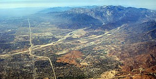
San Bernardino County, officially the County of San Bernardino, is a county located in the southern portion of the U.S. state of California, and is located within the Inland Empire area. As of the 2020 U.S. Census, the population was 2,181,654, making it the fifth-most populous county in California and the 14th-most populous in the United States. The county seat is San Bernardino.

The Tongva are an Indigenous people of California from the Los Angeles Basin and the Southern Channel Islands, an area covering approximately 4,000 square miles (10,000 km2). In the precolonial era, the people lived in as many as 100 villages and primarily identified by their village rather than by a pan-tribal name. During colonization, the Spanish referred to these people as Gabrieleño and Fernandeño, names derived from the Spanish missions built on their land: Mission San Gabriel Arcángel and Mission San Fernando Rey de España. Tongva is the most widely circulated endonym among the people, used by Narcisa Higuera in 1905 to refer to inhabitants in the vicinity of Mission San Gabriel. Some direct lineal descendants of the people advocate the use of their ancestral name Kizh as an endonym.

San Bernardino is a city and county seat of San Bernardino County, California, United States. Located in the Inland Empire region of Southern California, the city had a population of 222,101 in the 2020 census, making it the 18th-largest city in California. San Bernardino is the economic, cultural, and political hub of the San Bernardino Valley and the Inland Empire. The governments of El Salvador, Guatemala, and Mexico have established the metropolitan area’s only consulates in the downtown area of the city. Additionally, San Bernardino serves as an anchor city to the 3rd largest metropolitan area in California and the 13th largest metropolitan area in the United States; the San Bernardino-Riverside MSA.

The Santa Ana River is the largest river entirely within Southern California in the United States. It rises in the San Bernardino Mountains and flows for most of its length through San Bernardino and Riverside counties, before cutting through the northern Santa Ana Mountains via Santa Ana Canyon and flowing southwest through urban Orange County to drain into the Pacific Ocean. The Santa Ana River is 96 miles (154 km) long, and its drainage basin is 2,650 square miles (6,900 km2) in size.

The San Bernardino Mountains are a high and rugged mountain range in Southern California in the United States. Situated north and northeast of San Bernardino and spanning two California counties, the range tops out at 11,503 feet (3,506 m) at San Gorgonio Mountain – the tallest peak in all of Southern California. The San Bernardinos form a significant region of wilderness and are popular for hiking and skiing.

Mount San Antonio, commonly referred to as Mount Baldy or Old Baldy, is a 10,064 ft (3,068 m) summit in the San Gabriel Mountains on the border of Los Angeles and San Bernardino counties of California. Lying within the San Gabriel Mountains National Monument and Angeles National Forest, it is the high point of the range, the County of Los Angeles, and the Los Angeles metropolitan area.

The San Bernardino Valley is a valley in Southern California located at the south base of the Transverse Ranges. It is bordered on the north by the eastern San Gabriel Mountains and the San Bernardino Mountains; on the east by the San Jacinto Mountains; on the south by the Temescal Mountains and Santa Ana Mountains; and on the west by the Pomona Valley. Elevation varies from 590 feet (180 m) on valley floors near Chino to 1,380 feet (420 m) near San Bernardino and Redlands. The valley floor is home to over 80% of the more than 4 million people in the Inland Empire region.

Puvunga is an ancient village and sacred site of the Tongva nation, the Indigenous people of the Los Angeles Basin, and the Acjachemen, the Indigenous people of Orange County now located at California State University, Long Beach and the surrounding area. The Tongva know Puvunga as the "place of emergence" and it is where they believed "their world and their lives began." The site remains an important ceremonial site and ending to an annual pilgrimage for the Tongva, Acjachemen, and Chumash.
Lytle Creek, California, is an approximately 18-mile-long (29 km) stream in southwestern San Bernardino County near the city of San Bernardino. It is a tributary of Warm Creek, a tributary of the Santa Ana River. The Mormon settlers of San Bernardino named the stream "Lytle Creek" after their leader, Captain Andrew Lytle. The Tongva village of Wa’aachnga was located along Lytle Creek.

Lytle Creek is a census-designated place in the San Gabriel Mountains, within San Bernardino County.
Pasinogna is a former Tongva-Gabrieleño Native American settlement in San Bernardino County, California.
Brea Creek is one of four principal tributaries of Coyote Creek, which is a lower tributary of the San Gabriel River in California. It drains parts of Orange, Riverside, and San Bernardino counties. The creek flows 11.7 miles (18.8 km) from the cities of Brea and Anaheim to Whittier, where its mouth is on the left bank of Coyote Creek, at a point 481 feet (147 m) lower in elevation.
Politana or Apolitana was the first Spanish settlement in the San Bernardino Valley of California. It was established as a mission chapel and supply station by the Mission San Gabriel in the a rancheria of the Guachama Indians that lived on the bluff that is now known as Bunker Hill, near Lytle Creek. Besides the Guachama, it was also at various times the home for colonists from New Mexico and Cahuilla people. Its most prominent landmark today is the St. Prophet Elias Greek Orthodox Church on Colton Avenue, just southwest of the Inland Center Mall, in San Bernardino, California.
Kaawchama, alternatively referred to as Wa’aachnga, was a significant Tongva village in the San Bernardino Valley located in what is now west Redlands, California. The village became referred to by the Spanish as the Guachama Rancheria in 1810 after a supply station was constructed at the village for Mission San Gabriel, which then became part of Rancho San Bernardino following the secularization of the missions in 1833.

Yaanga was a large Tongva village originally located near what is now downtown Los Angeles, just west of the Los Angeles River and beneath U.S. Route 101. People from the village were recorded as Yabit in missionary records although were known as Yaangavit, Yavitam, or Yavitem among the people. It is unclear what the exact population of Yaanga was prior to colonization, although it was recorded as the largest and most influential village in the region.
Wapijanga was a Tongva village located in what is now Chino Hills, California, between the San Gabriel Mountains and Saddleback Peak. The village was located along Chino Creek, upstream from the village of Pashiinonga. It has been alternatively referred to as Wajijanga and Wapijangna. It was recorded as a large village in San Gabriel Mission records.
Paxauxa was a shared Tongva and Payómkawichum village site located at what is now Corona, California along Temescal Creek. Villagers may have appeared in baptismal records at Mission San Juan Capistrano as being from the village Axaxa. Nearby villages included Poruumanga and Shiishonga. It is sometimes alternatively spelled Pakhavka.

Achooykomenga is a former settlement that was located at the site of Mission San Fernando Rey de España before it was founded in 1797. Prior to the mission's founding, in the 1780s, it functioned as a shared native settlement for an agricultural rancho of Pueblo de Los Ángeles that was worked by Ventureño Chumash, Fernandeño (Tongva), and Tataviam laborers.

Guashna was a Tongva village located at Playa Vista, Los Angeles at the mouth of Ballona Creek. The site has also been referred to as Sa'angna, with various sources debating whether Sa'angna, meaning "place of tar," was a regional referent rather than a village name or whether it was a separate nearby village. The initial place name was said to be Sa'an; the village suffix "ngna" was added by Bernice Johnston to her 1962 map of Gabrieleño villages "despite her having found no mention of the term in baptismal records." Sa'angna is also not to be confused with Suangna. The Tongva referred to the Ballona Wetlands as Pwinukipar, meaning "full of water." Another alternate name may Waachnga.
References
- 1 2 Initial Study for Southern California Edison Company's (PDF). CA.gov. 1997. pp. 7, 12.
- ↑ Audet, Emily. "White" Space: The Racialization of Claremont, California. p. 42.
- ↑ "S-3 Pageant of History". sbcity.org. Retrieved 2022-12-16.
- ↑ The Earliest Historical Relations Between Mexico and Japan: From Original Documents Preserved in Spain and Japan, Volume 4, Issues 1-6. p. 134.
|