
The Khajuraho Group of Monuments are a group of Hindu and Jain temples in Chhatarpur district, Madhya Pradesh, India, about 175 kilometres southeast of Jhansi. They are a UNESCO World Heritage Site. The temples are famous for their nagara-style architectural symbolism and their erotic sculptures.

Vidisha is a city in central Madhya Pradesh, India. It is located 62.5 km northeast of the state capital, Bhopal. The name "Vidisha" is derived from the nearby river "Bais", mentioned in the Puranas.

Mandsaur is a city and a municipality in Mandsaur district located on Border of Mewar and Malwa region of Madhya Pradesh state of central India. It is the administrative headquarters of Mandsaur District. The ancient Pashupatinath Temple is located in Mandsaur. It is also famous for large production of Opium around the world.
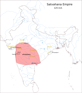
The Satavahanas, also referred to as the Andhras in the Puranas, were an ancient Indian dynasty based in the Deccan region. Most modern scholars believe that the Satavahana rule began in the late second century BCE and lasted until the early third century CE, although some assign the beginning of their rule to as early as the 3rd century BCE based on the Puranas, but uncorroborated by archaeological evidence. The Satavahana kingdom mainly comprised the present-day Andhra Pradesh, Telangana, and Maharashtra. At different times, their rule extended to parts of modern Gujarat, Madhya Pradesh, and Karnataka. The dynasty had different capital cities at different times, including Pratishthana (Paithan) and Amaravati (Dharanikota).
The Western Satraps, or Western Kshatrapas were Indo-Scythian (Saka) rulers of the western and central part of India, between 35 to 405 CE. The Western Satraps were contemporaneous with the Kushans who ruled the northern part of the Indian subcontinent, and were possibly vassals of the Kushans. They were also contemporaneous with the Satavahana (Andhra) who ruled in Central India. They are called "Western Satraps" in modern historiography in order to differentiate them from the "Northern Satraps", who ruled in Punjab and Mathura until the 2nd century CE.

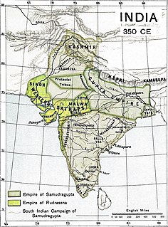
The Vakataka Empire was a dynasty from the Indian subcontinent that originated from the Deccan in the mid-3rd century CE. Their state is believed to have extended from the southern edges of Malwa and Gujarat in the north to the Tungabhadra River in the south as well as from the Arabian Sea in the west to the edges of Chhattisgarh in the east. They were the most important successors of the Satavahanas in the Deccan and contemporaneous with the Guptas in northern India.
Dakshina Kosala is a historical region of central India. It was located in what is now Chhattisgarh and western part of Odisha. At its greatest extent, it may have also included a part of the Vidarbha region in present-day Maharashtra.

Mushika dynasty, also spelled Mushaka, was a minor dynastic power that held sway over the region in and around Mount Ezhi (Ezhimala) in present-day North Malabar, Kerala, India. The present-day Kolathiris are descendants of the ancient Mushika dynasty. The country of the Mushikas, ruled by an ancient lineage of the Velir clan of the same name, appears in early historic (pre-Pallava) south India. Early Tamil poems contain several references to the exploits of Nannan of Ezhimalai. Nannan was known as a great enemy of the pre-Pallava Chera chieftains. The clan also had matrimonial alliances with the Chera, Pandya and Chola chieftains. The Kolathunadu (Kannur) Kingdom, which was the descendant of Mushika dynasty, at the peak of its power, reportedly extended from Netravati River (Mangalore) in the north to Korapuzha (Kozhikode) in the south with Arabian Sea on the west and Kodagu hills on the eastern boundary, also including the isolated islands of Lakshadweep in the Arabian Sea.

Arang, also known as "The town of temples" of Chhattisgarh, is a block and a Nagar Palika in Raipur District in the state of Chhattisgarh, India. It is situated near the eastern limits of Raipur City and close to Mahasamund City. Arang is an ancient town, which was ruled by the Haihayas Rajput dynasty. It is famous for its many Jain and Hindu temples which belong to the 11th and 12th centuries; these are the Mand Deval Jain temple, the Mahamaya temple, the Panchmukhi temple and the Hanuman temple. Due to the Archaeological finds of a copper plate inscription dated to the Gupta Empire, known as the Arang Plate of Bhimasena II of the clan of Rajarsitulya, has established the town's ancient history as a Hindu and Jain religious centre, which was then under the rule of Hindu kings. The Mand Deval Jain temple is the most ancient of these temples dated to the 11th century where three huge images of Digambara tirthankaras are deified in the sanctum sanctorum; these are carved in black stone and polished.

Bagh is a census town in Dhar district in the state of Madhya Pradesh, India. It is known for the Bagh Caves, which are late 4th- to 6th-century Buddhist rock-cut chambers with murals. The name of the town stems from the caves - according to local legend there were living tigers in these abandoned Buddhist caves.
Anupa is an ancient Indian region roughly corresponds to the areas around ancient Mahishmati city in the present-day Madhya Pradesh. The Vayu Purana mentions a janapada (realm) of Anupa, located on the Vindhyaprishtha. The Nasik cave inscription of Gautami Balashri claims that her son Gautamiputra Satakarni's dominion included Anupa. The Junagarh rock inscription of Rudradaman I mentions Anupa as a part of his kingdom.

Eran is an ancient town and archaeological site in the Sagar district of Madhya Pradesh, India. It was one of the ancient mints for Indian dynasties as evidenced by the diverse coins excavated here. The site has 5th and 6th-century Gupta era temples and monuments, particularly the colossal stone boar with sages and scholars depicted on the body of the sculpture. The inscription stones found at Eran are important to reconstructing the chronology of Gupta Empire history. Eran or Erakina was the capital of Erakina (Airikina) Pradesha or Airkina Vishaya, an administrative division of the Gupta empire.

Deogarh is a village in Lalitpur district of the Indian state of Uttar Pradesh. It is located on the right bank of Betwa River and to the west of Lalitpur hills. It is known for Gupta monuments and for many ancient monuments of Hindu and Jain origins inside and outside the walls of the fort.
Mahendrapala I (885–910) was a kshatriya ruler of Gurjara-Pratihara dynasty, the son of Mihir Bhoja I and queen Candra-Bhatta-Rika-Devi. He was also mentioned on various inscriptions in Kathiawar, Punjab and Madhya Pradesh by names Mahindrapala, Mahendrayudha, Mahisapaladeva, and also Nirbhayaraja and Nirbhayanarendra in the plays of Rajasekhara.

The Aulikaras, also referred to as Aulikara dynasty or Olikara dynasty, were an ancient Indian clan from the Maurya era, that emerged into a kingdom between the 4th-century CE and 6th-century CE. They were based in the Malwa (Malawa) region of central India near Mandsaur, with their power center near what is now western Madhya Pradesh, southeastern Rajasthan and northeastern Gujarat. Two royal houses belonging to this clan ruled over the present-day western Malwa region of Madhya Pradesh state from c. 350 CE to 550 CE, much of it as feudatories of the Gupta Empire.

Armamalai Cave is known for its Indian cave paintings. It is to the west of Malayampattu village which is 25 kilometres (16 mi) from Ambur in the Tirupattur district of Tamil Nadu. The cave is in the protected monument by the Archaeological Survey of India and it is a Tamil Nadu tourist attraction.
Udaipur is a town in the Indian state of Madhya Pradesh near Ganj Basoda. It is the site of a well-preserved Śiva temple, a monument of national importance protected by the Archaeological Survey of India.
The Maharajas of Valkha were part of a central Indian dynasty that ruled the historical Valkha region. They are known from several inscriptions dated to the years 38-134 of an unspecified calendar era. Based on the identification of this era with the Gupta era, they are believed to have ruled during 4th and 5th centuries CE. These rulers of Valkha were probably vassals of the Gupta emperors.

The Vasu Doorjamb Inscription is an early 1st-century CE Sanskrit inscription in Brahmi script dedicated to the deity Vāsudeva, related to the Vaishnavism tradition of Hinduism. It is also one of the several dedicatory inscriptions from Mathura bearing the name of the Indo-Scythian Northern Satrap ruler Sodasa, which are useful as historic markers for the first half of the 1st century CE.

The Abhira dynasty was a dynasty that ruled over the western Deccan, where they succeeded the Satavahanas. From 203 to roughly 260, they formed a vast kingdom. They were from the Abhira kshatriya clan.


