
Rappahannock County is a county located in the Commonwealth of Virginia, US. As of the 2010 census, the population was 7,373. Its county seat is Washington. The name "Rappahannock" comes from the Algonquian word lappihanne, meaning "river of quick, rising water" or "where the tide ebbs and flows."

Annandale is a census-designated place (CDP) in Fairfax County, Virginia. The population of the CDP was 41,008 as of the 2010 United States Census. It is home to the oldest and largest branch of the Northern Virginia Community College system, and to one of the D.C. area's Koreatowns.

Wakefield is an incorporated town in Sussex County, Virginia, United States. The population was 927 at the 2010 census.
West Yorkshire is a metropolitan and ceremonial county in England. It is an inland and, in relative terms, upland county having eastward-draining valleys while taking in the moors of the Pennines. West Yorkshire came into existence as a metropolitan county in 1974 after the passage of the Local Government Act 1972 and has a population of 2.3 million.

Wakefield is a cathedral city in the City of Wakefield district of West Yorkshire, England. The city is on the River Calder and the Pennines eastern edge.

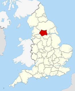
The City of Wakefield is a local government district in West Yorkshire, England, with the status of a city and metropolitan borough. Wakefield is the district's administrative centre. The population of the City of Wakefield at the 2011 Census was 325,837. The district includes the ‘Five Towns’ of Normanton, Pontefract, Featherstone, Castleford and Knottingley. Other towns include Ossett, Horbury, Hemsworth, South Kirkby and Moorthorpe and South Elmsall. The City and borough are governed by Wakefield Metropolitan District Council. Wakefield is located between Leeds and Barnsley

The George Washington Birthplace National Monument is a national monument in Westmoreland County, Virginia, United States. This site was developed in the mid-17th century as a colonial tobacco plantation by Englishman John Washington. A member of the assembly, he was a great-grandfather of George Washington, general and the first United States president. George Washington was born in this house on February 22, 1732. He lived here until age three, returning later to live here as a teenager.
Port Wakefield Road and Port Wakefield Highway are an important South Australian highway. They connect Adelaide to the Yorke Peninsula, Port Augusta, northern and western South Australia, the Northern Territory and Western Australia. They are designated National Highway A1 and a part of the National Highway. They are named after Port Wakefield, the first government town north of Adelaide. Historically, the whole route was named Port Wakefield Road, however following the opening of the Northern Expressway, the route north of that junction was named Port Wakefield Highway.
The Division of Bonython was an Australian Electoral Division in South Australia between 1955 and 2004. In its final configuration, it was based on the outer northern suburbs of Elizabeth, Munno Para, Parafield, Paralowie, Salisbury, Virginia, and to the town of One Tree Hill in Adelaide's outskirts. Bonython's first 14 years saw vast boundaries simultaneously cover as far north as Gawler, as far south as Magill Road at Norwood, and as far west as Ottoway. The seat would continue to cross south of Grand Junction Road until the creation of the Division of Makin at the pre-1984 redistribution.

The Division of Wakefield was an Australian electoral division in the state of South Australia. The seat was a hybrid rural-urban electorate that stretched from Salisbury in the outer northern suburbs of Adelaide at the south of the seat right through to the Clare Valley at the north of the seat, 135 km from Adelaide. It included the suburbs of Elizabeth, Craigmore, Munno Para, and part of Salisbury, and the towns of Balaklava, Clare, Freeling, Gawler, Kapunda, Mallala, Riverton, Tarlee, Virginia, Williamstown, and part of Port Wakefield.

SS America was an ocean liner and cruise ship built in the United States in 1940, for the United States Lines and designed by the noted American naval architect William Francis Gibbs. She carried many names in the 54 years between her construction and her 1994 wreck:
Wakefield School is an independent day school located in The Plains, Virginia, with classes ranging from junior kindergarten to 12th grade. It was founded in Huntly, Virginia in 1972 as Wakefield Country Day School, and changed its name to Wakefield School in the early 1980s when it established a small boarding department. After a disagreement with the founders of the school, the half of the board of trustees moved the school from the Huntly location and re-founded the school at Marshall, Virginia in 1991, and moved later to Archwood Farm in The Plains in 1996. However, the original campus, headed by the original founders, continues to operate as a separate school, Wakefield Country Day School. Between 1996 and today, Wakefield grew from a school of 240 students to the current enrollment of about 332 as the campus was developed.
Wakefield High School is one of three public high schools located in Arlington, Virginia, United States, closely bordering Alexandria. It has 140 teachers and 2,104 students in grades 9–12 as of the 2016–2017 academic year.
Wakefield is a city in West Yorkshire, England.

Virginia is a town on the rural outskirts of Adelaide, the capital city of South Australia. Port Wakefield Road, the main highway taking traffic to the north of Adelaide, passes through the area and used to pass straight through Virginia. Market gardening is the main activity there.

Long Branch is a census-designated place in Fairfax County, Virginia, bordering the city of Fairfax. The population as of the 2010 census was 7,593.

Wakefield is a census-designated place in Fairfax County, Virginia, United States. The population as of the 2010 census was 11,275.

Woodburn is a census-designated place in Fairfax County, Virginia, United States. The population as of the 2010 census was 8,480.

An unusually prolific and very destructive late-winter tornado outbreak resulted in significant damage and numerous casualties across the southern and eastern half of the United States between February 23–24, 2016. Lasting nearly a day and a half, the outbreak produced a total of 61 tornadoes across eleven states, which ranked it as one of the largest February tornado outbreaks in the United States on record, with only the 2008 Super Tuesday tornado outbreak having recorded more. In addition, it was also one of the largest winter tornado outbreaks overall as well. The most significant and intense tornadoes of the event were four EF3s that struck southeastern Louisiana, Pensacola, Florida, Evergreen, Virginia, and Tappahannock, Virginia. Tornadoes were also reported in other places like Texas, Florida, and Pennsylvania. Severe thunderstorms, hail and gusty winds were also felt in the Northeastern United States and Mid-Atlantic states on February 24 as well.

The District Council of Munno Mara West was a local government area of South Australia on the central Adelaide Plains from 1854 to 1933.


