Colonial Heights is an independent city in the Commonwealth of Virginia. As of the 2010 census, the population was 17,411. The Bureau of Economic Analysis combines the City of Colonial Heights with Chesterfield County for statistical purposes.

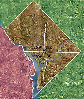
Northwest is the northwestern quadrant of Washington, D.C., the capital of the United States, and is located north of the National Mall and west of North Capitol Street. It is the largest of the four quadrants of the city, and it includes the central business district, the Federal Triangle, and the museums along the northern side of the National Mall, as well as many of the District's historic neighborhoods.
Woodland Heights is the name of four places in the United States of America:

Neighborhoods in Washington, D.C., are distinguished by their history, culture, architecture, demographics, and geography. The names of 131 neighborhoods are unofficially defined by the D.C. Office of Planning. Neighborhoods can be defined by the boundaries of wards, historic districts, Advisory Neighborhood Commissions, civic associations, and business improvement districts (BIDs); these boundaries will overlap. The eight wards each elect a member to the Council of the District of Columbia and are redistricted every ten years.

Parkland County is a municipal district in central Alberta, Canada. Located west of Edmonton in Census Division No. 11, its municipal office, Parkland County Centre, is located 0.25 km (0.16 mi) north of the Town of Stony Plain on Highway 779.

Woodland Heights, VA is a neighborhood in the city of Richmond, Virginia. It began as a trolleycar neighborhood in the early 1900s and was built up along the James River beside Forest Hill Park. Woodland Heights is listed on the National Register of Historic Places and the Virginia Landmarks Registry.

The Woodland Heights neighborhood is one of the oldest and most historic in Houston, Texas. It encompasses approximately 2000 homes in the 77009 ZIP code and is bounded on the north by Pecore Street, on the west by Studewood Street, on the east by I-45, and on the south by I-10.

Woodland Park is an exclusively residential neighborhood in the Northeast section of Portland, Oregon. It borders Madison South on the west, Parkrose Heights on the north and east, and Hazelwood on the south. It is roughly between NE 99th and 102nd, and NE Halsey and NE Tillamook.
Pennsylvania Route 50 is a 32.7-mile-long (52.6 km) state highway located in western Pennsylvania. The western terminus of the route is at PA 844 in the Independence Township community of Independence less than a mile from the West Virginia state line. The eastern terminus is at PA 60 in Crafton Heights. Part of its routing used to be PA 28, which now terminates in the Pittsburgh neighborhood of Crafton Heights.

Woodland Normanstone is a small, residential neighborhood in Northwest Washington, D.C., adjoining the larger neighborhoods of Woodley Park, Massachusetts Avenue Heights, and Observatory Circle.

Elklick Woodlands Natural Area Preserve is a 226-acre (91 ha) Natural Area Preserve located in Fairfax County, Virginia. Owned by the Fairfax County Park Authority, it is protected with a local conservation easement, and preserves a globally rare natural community known as a "northern hardpan basic oak-hickory forest". This kind of forest occurs on diabase soil with an underlay of dense plastic clay; such terrain is called "shrink-swell soil" due to extreme variations in moisture availability exhibited throughout the year. Trees which grow in such an environment are stunted, and their relatively open canopies encourage the growth of a wide variety of grasses and herbs in the understory. Such forests were once common around northern Virginia, but many have been lost due to increasing suburbanization of the area.

Woodland Heights is an unincorporated community in Sussex County, Delaware, United States. Woodland Heights is north of Laurel.

Charlton Heights is a census-designated place (CDP) in Fayette County, West Virginia, United States. Charlton Heights is located on the north bank of the Kanawha River 4 miles (6.4 km) southwest of Gauley Bridge. Charlton Heights has a post office with ZIP code 25040. As of the 2010 census, its population was 406.

Montgomery Heights is an unincorporated community in Fayette County, West Virginia, United States. Montgomery Heights is located on the south bank of the Kanawha River 4.5 miles (7.2 km) southeast of Montgomery.

Tyler Heights, also known as Flatwoods, is an unincorporated community in Kanawha County, West Virginia, United States. Tyler Heights is located along West Virginia Route 622 at its junction with West Virginia Route 501, 5 miles (8.0 km) east-northeast of Nitro.

Woodland Park is an unincorporated community in Wood County, West Virginia, United States.


