Mineral County is a county in the U.S. state of West Virginia. It is part of the Cumberland, MD-WV Metropolitan Statistical Area. As of the 2010 census, the population was 28,212. Its county seat is Keyser. The county was founded in 1866.

Scouting in West Virginia has a long history, from the 1910s to the present day, serving thousands of youth in programs that suit the environment in which they live.

The Monongahela National Forest is a national forest located in the Allegheny Mountains of eastern West Virginia, USA. It protects over 921,000 acres of federally owned land within a 1,700,000 acres proclamation boundary that includes much of the Potomac Highlands Region and portions of 10 counties.

Meadow Branch is a 16.7-mile-long (26.9 km) tributary stream of Sleepy Creek in West Virginia's Eastern Panhandle region. It passes through the Sleepy Creek Wildlife Management Area, where it is dammed to form the 205-acre (0.83 km2) Sleepy Creek Lake.

Canaan Valley Resort State Park is a state park in the eastern United States, within Canaan Valley in Tucker County, West Virginia. Located in the highest valley east of the Mississippi River, the park contains the second-largest inland wetland area in the United States. The valley featured the first commercial ski development in West Virginia.

Blackwater Falls State Park is located in the Allegheny Mountains of Tucker County, West Virginia, USA. The centerpiece of the park is Blackwater Falls, a 62-foot (19 m) cascade where the Blackwater River leaves its leisurely course in Canaan Valley and enters rugged Blackwater Canyon. It is among the most photographed venues in the state and appears on calendars, stationery, and advertisements. The river is named for its tannin-darkened water.

The Canaan Valley National Wildlife Refuge (CVNWR) in Tucker County, West Virginia, was the 500th National Wildlife Refuge (NWR) to be established in the United States. The refuge preserves a moist valley with unique wetlands and uplands at a relatively high elevation in the Allegheny Mountains. It is administered by the U.S. Fish and Wildlife Service (USFWS).

Canaan Valley is a large bathtub shaped upland valley in northeastern Tucker County, West Virginia, USA. Within it are extensive wetlands and the headwaters of the Blackwater River which spills out of the valley at Blackwater Falls. It is a well-known and partially undeveloped scenic attraction and tourist draw, associated with the Canaan Valley Resort State Park and the Blackwater Falls State Park.

Delaplane is an unincorporated community in northern Fauquier County, Virginia, approximately 50 miles (80 km) due west of Washington, D.C. Delaplane is situated along U.S. Route 17, U.S. Route 50, and Interstate 66; bordering Upperville, Virginia to the north, Hume, Virginia to the south, Paris, Virginia to the west, and Rectortown, Virginia to the east. Delaplane, Virginia has a ZIP Code of 20144.

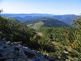
Shavers Mountain, is a high and rugged ridge situated in the Allegheny Mountains of eastern West Virginia. It is about 35 miles (56 km) long, north to south, and several of its peaks exceed 4,000 feet (1,200 m) in elevation. Shavers Mountain is notable for being "bookended", at its northern and southern ends, by two exceptional natural areas: the Otter Creek Wilderness and the Gaudineer Scenic Area, respectively, both of which preserve small stands of old growth forest on the mountain.

Valley Bend Wildlife Management Area is located on 31 acres (13 ha) southwest of Valley Bend in Randolph County, West Virginia.

The Otter Creek Wilderness is a U.S. Wilderness area located in the Cheat-Potomac Ranger District of Monongahela National Forest in West Virginia, USA. The Wilderness sits in a bowl-shaped valley formed by Otter Creek, between McGowan Mountain and Shavers Mountain in Tucker and Randolph Counties. It is crossed by 42 miles (68 km) of hiking trails. Otter Creek Trail is the longest, at 11 miles (18 km).

Bear Rock Lakes Wildlife Management Area is a 242-acre (98 ha) protected area located in Ohio County, West Virginia, about 8 miles (13 km) east of Wheeling. The terrain at Bear Rock Lakes is rolling hills covered by a combination of hardwood forest and open fields.

Sleepy Creek Wildlife Management Area is located in Morgan and Berkeley Counties in West Virginia's Eastern Panhandle. It encompasses 22,928 acres (92.79 km2), mostly covered with mixed oak and pine forest, although about 3,500 acres (14 km2) are covered with mixed hardwoods. The 205-acre (83 ha) Sleepy Creek Lake is located entirely within the WMA.
The Roaring Plains West Wilderness is a U.S. Wilderness Area in the Allegheny Mountains of eastern West Virginia, USA. It is part of the Monongahela National Forest and includes Mount Porte Crayon, the sixth highest point in the state.

Ohio Valley University is a private Christian college located between Parkersburg and Vienna in West Virginia.

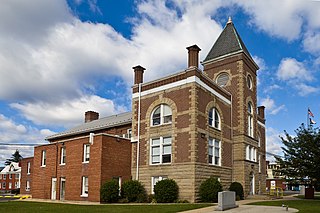
Valley View is a mid-19th-century Greek Revival residence and farm overlooking the South Branch Potomac River northwest of Romney, West Virginia. The house is atop a promontory where Depot Valley joins the South Branch Potomac River valley.
Valley was a populated place and post office on the South Branch line of the Baltimore and Ohio Railroad in the U.S. state of West Virginia. It was centered near the intersection of West Sioux Lane and Depot Valley Road, now located within the present-day corporate boundaries of Romney. Valley developed in 1884 following the completion of the South Branch line when the rail line's original southern terminus and corresponding Romney Depot were built there. The United States Post Office Department established a post office at Valley on May 19, 1928, remaining in operation until its disestablishment on June 15, 1937. Following the closure of Valley's post office, its mail was routed through the post office in Romney.

Barbours Creek Wilderness is a U.S. wilderness area in the Eastern Divide Ranger District of George Washington and Jefferson National Forests of western Virginia, United States. The wilderness area was established in 1988 and consists of 5,382 acres (2,178 ha) of forests in the Appalachian Mountains ranging in elevation from 1,700 to 3,800 feet.

Booker T. Washington State Park is a former state park near the community of Institute in the U.S. state of West Virginia. The park was operated by the West Virginia Conservation Commission, Division of State Parks, from 1949 until the late 1950s.


