
Kanawha County is a county in the U.S. state of West Virginia. As of the 2019 American Community Survey, the population was 183,279. This was a decrease of 9,784 since the 2010 Census; nevertheless, it is West Virginia's most populous county. The county seat is Charleston, which is also the state capital. Kanawha County is part of the Charleston, WV Metropolitan Statistical Area.

Clarke County is a county in the Commonwealth of Virginia. As of the 2010 census, the population was 14,034. Its county seat is Berryville. Clarke County is included in the Washington-Arlington-Alexandria, DC-VA-MD-WV Metropolitan Statistical Area.

Jefferson County is located in the north central portion of the U.S. Commonwealth of Kentucky. As of the 2010 census, the population was 741,096. It is the most populous county in the commonwealth.

Virginia Water is a commuter town or village in northern Surrey, home to the Wentworth Estate and the Wentworth Club. The place occupies a large majority of the Borough of Runnymede. Its name is shared with the lake on its western boundary with Windsor Great Park. Virginia Water is close to the M25, M4 and M3 motorways. Heathrow Airport is seven miles to the north-east.
This article is about the many neighborhoods and districts in the Greater Richmond, Virginia area. Note that this article is an attempt to be inclusive of the broader definitions of the areas which are often considered part of the Greater Richmond Region, based on their urban or suburban character and nature, rather than by strictly political boundaries.
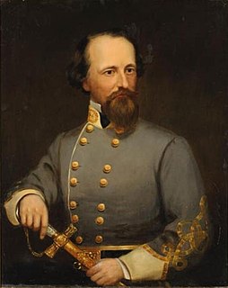
James Johnston Pettigrew was an American author, lawyer, and soldier. He served in the army of the Confederate States of America, fighting in the 1862 Peninsula Campaign and played a prominent role in the Battle of Gettysburg. Despite starting the Gettysburg Campaign commanding a brigade, Pettigrew took over command of his division after the division's original commander Henry Heth was wounded. In this role, Pettigrew was one of three division commanders in the disastrous assault known as Pickett's Charge on the final day of Gettysburg. He was badly wounded during the assault and was later mortally wounded during a Union attack while the Confederates retreated to Virginia near Falling Waters, West Virginia, dying several days later.

Shadwell is a census-designated place (CDP) in Albemarle County, Virginia, United States, located by the Rivanna River near Charlottesville. The site today is marked by a Virginia Historical Marker to mark the birthplace of President Thomas Jefferson. It is listed on the National Register of Historic Places along with Clifton.

Catoctin Mountain, along with the geologically associated Bull Run Mountains, forms the easternmost mountain ridge of the Blue Ridge Mountains, which are in turn a part of the Appalachian Mountains range. The ridge runs northeast/southwest for about 50 miles (80 km) departing from South Mountain near Emmitsburg, Maryland, and running south past Leesburg, Virginia, where it disappears into the Piedmont in a series of low-lying hills near Aldie, Virginia. The ridge forms the eastern rampart of the Loudoun and Middletown valleys.

Parkland County is a municipal district in central Alberta, Canada. Located west of Edmonton in Census Division No. 11, its municipal office, Parkland County Centre, is located 0.25 km (0.16 mi) north of the Town of Stony Plain on Highway 779.
Lowry Hill is a neighborhood within the Calhoun-Isles community in Minneapolis, Minnesota. The neighborhood is named for the terminal moraine on which it sits, a hill named after late nineteenth century real estate mogul and trolley tycoon Thomas Lowry. Its boundaries are Interstate 394 to the north, Interstate 94 to the east, Hennepin Avenue to the southeast, West 22nd Street to the south, Lake of the Isles Parkway to the southwest, and Logan Avenue South and Morgan Avenue South to the west. Lowry Hill is northwest of Lowry Hill East; the two neighborhoods are separated by Hennepin Avenue.
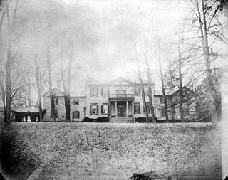
Ravensworth was an 18th-century plantation house near Annandale in Fairfax County, Virginia. Ravensworth was the Northern Virginia residence of William Fitzhugh, William Henry Fitzhugh, Mary Lee Fitzhugh Custis, William Henry Fitzhugh Lee and George Washington Custis Lee. It was built in 1796.

Hollindale is an unincorporated community in Fort Hunt, Fairfax County, Virginia, United States close to the George Washington Memorial Parkway in ZIP code 22306. As of 2013, it had 945 residents. Mount Vernon Presbyterian Church and Hollin Meadows Elementary School are located within the community. Hollindale is set along the hilly woodlands across from the Potomac. It was built around several estates and on what used to be Sherwood Dairy Farm, and is adjacent to the Hollin Hills community. It is dominated by mid-century modern homes, colonials, and Tudors.
Burley Park is a neighborhood in southwestern Lexington, Kentucky, United States. It is named for the large number of tobacco warehouses that were once located in the neighborhood. Its boundaries are Waller Avenue and Mason Headley Road to the south, east of Beacon Hill Drive/ Summerville Drive/ Addison Park to the west, Red Mile Road and Virginia Avenue to the north, and RJ Corman railroad tracks to the east. The smaller Golf View Estates neighborhood is typically included in Burley Park.
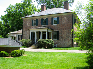
Fall Hill is a plantation located near the falls on the Rappahannock River in Fredericksburg, Virginia. Though the Thornton family has lived at Fall Hill since the early 18th century, the present house was built in 1790 for Francis Thornton V (1760–1836). The land on which Fall Hill is located is part of an 8,000 acres (3,200 ha) land patent obtained by Francis Thornton I (1657–1727) around 1720. The present-day town of Fredericksburg, Virginia is located on that original patent.

Gambles Hill is a neighborhood near Downtown Richmond, Virginia. The neighborhood contains the Virginia War Monument, Historic Tredegar, Brown's Island and the WestRock Corporation.
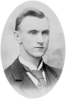
Howard Llewellyn Swisher was an American businessperson, real estate developer, orchardist, editor, writer, and historian. As a prominent businessman, he established several companies responsible for the development of businesses and real estate in Morgantown, West Virginia.


