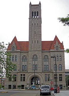
Lynchburg is an independent city in the Commonwealth of Virginia in the United States. As of the 2010 census, the population was 75,568. The 2017 census estimates an increase to 81,000. Located in the foothills of the Blue Ridge Mountains along the banks of the James River, Lynchburg is known as the "City of Seven Hills" or the "Hill City". In the 1860s, Lynchburg was the only major city in Virginia that was not recaptured by the Union before the end of the American Civil War.

Interstate 77 (I-77) is a north–south Interstate Highway in the eastern United States. It traverses diverse terrain, from the mountainous state of West Virginia to the rolling farmlands of North Carolina and Ohio. It largely supplants the old U.S. Route 21 between Cleveland, Ohio, and Columbia, South Carolina, as an important north–south corridor through the middle Appalachians. The southern terminus of Interstate 77 is in Columbia at the junction with Interstate 26. The northern terminus is in Cleveland at the junction with Interstate 90. The major cities that I-77 connects to include Cleveland, Ohio; Akron, Ohio; Charleston, West Virginia; Charlotte, North Carolina; and Columbia, South Carolina. The East River Mountain Tunnel, connecting Virginia and West Virginia, is one of only two instances in the United States where a mountain road tunnel crosses a state line. The other is the Cumberland Gap Tunnel, connecting Tennessee and Kentucky.

Jefferson County is a county located in the U.S. Commonwealth of Kentucky. As of the 2010 census, the population was 741,096. It is the most populous county in the commonwealth.

Catonsville is a census-designated place (CDP) in Baltimore County, Maryland, United States. The population was 41,567 at the 2010 census. The community lies to the west of Baltimore along the city's border. Catonsville contains the majority of the University of Maryland, Baltimore County (UMBC), a major public research university with close to 14,000 students.

The Monongahela River — often referred to locally as the Mon — is a 130-mile-long (210 km) river on the Allegheny Plateau in north-central West Virginia and southwestern Pennsylvania, which flows from south to north. The Monongahela joins the Allegheny River to form the Ohio River at Pittsburgh.
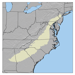
The Piedmont is a plateau region located in the Eastern United States. It sits between the Atlantic coastal plain and the main Appalachian Mountains, stretching from New Jersey in the north to central Alabama in the south. The Piedmont Province is a physiographic province of the larger Appalachian division which consists of the Gettysburg-Newark Lowlands, the Piedmont Upland and the Piedmont Lowlands sections.

The Virginian Railway was a Class I railroad located in Virginia and West Virginia in the United States. The VGN was created to transport high quality "smokeless" bituminous coal from southern West Virginia to port at Hampton Roads.
Rolling hills are a series of low hills; rolling refers to the up-and-down motion of riding over them. As a place name, Rolling Hills may refer to:

Blue Ridge Mountain, also known as Blue Mountain, is the colloquial name of the westernmost ridge of the Blue Ridge Mountains in northern Virginia and the Eastern Panhandle of West Virginia. The Appalachian Trail traverses the entire length of the mountain along its western slope and crest.
The Piedmont region of Virginia is a part of the greater Piedmont physiographic region which stretches from the falls of the Potomac, Rappahannock, and James Rivers to the Blue Ridge Mountains. The region runs across the middle of the state from north to south, expanding outward to a width of nearly 190 miles at the border with North Carolina. To the north, the region continues from Virginia into central Maryland and southeastern Pennsylvania.

Castle Mountain is a forested mountain ridge in Pendleton County, West Virginia, in the United States. Running from the southwest to the northeast, the mountain is bounded to its west by North Fork Mountain and to its east by a series of rolling hills.
Tilhance Creek is a 10.4-mile-long (16.7 km) tributary stream of Back Creek in Berkeley County of West Virginia's Eastern Panhandle.
The 7th West Virginia Volunteer Infantry Regiment was an infantry regiment that served in the Union Army during the American Civil War. For much of the war, it was a part of the famed "Gibraltar Brigade" in the Army of the Potomac. It was famed primarily for two major actions, a determined charge on the Sunken Road at Antietam and a late evening counterattack on East Cemetery Hill at Gettysburg that helped push back an attack by the Louisiana Tigers.

Bear Rock Lakes Wildlife Management Area is a 242-acre (98 ha) protected area located in Ohio County, West Virginia, about 8 miles (13 km) east of Wheeling. The terrain at Bear Rock Lakes is rolling hills covered by a combination of hardwood forest and open fields.

Cross Creek Wildlife Management Area is located on 630 acres (250 ha) in Brooke County near Wellsburg, West Virginia. Mixed hardwoods cover most of the former strip mine site. The rolling terrain is punctuated with a few highwalls and ponds. Cross Creek WMA can be reached by State Route 7 about 6 miles (9.7 km) northeast of Wellsburg.

Hillcrest Wildlife Management Area is located in Hancock County near New Cumberland, West Virginia. Located on 2,212 acres (895 ha) of former farmland, the flat bottoms and rolling hills provide open fields, old orchards and small forest lots.

Upper Deckers Creek Wildlife Management Area, is located about 1 mile (1.6 km) north of Reedsville, West Virginia in Preston County. Upper Deckers Creek WMA is located on 56 acres (23 ha), consisting of two small fishing ponds and surrounding forested rolling hills.
Crown Hill is an unincorporated community in Kanawha County, West Virginia, United States. Crown Hill is located on the south bank of the Kanawha River along West Virginia Route 61 1.8 miles (2.9 km) west-southwest of Pratt. Crown Hill once had a post office, which closed on February 1, 1997.

"Muswell Hillbilly" is a track recorded by British rock band The Kinks. It served as the title track to their 1971 album, Muswell Hillbillies.