Forest Hills | |
---|---|
Unincorporated community | |
Coordinates: 39°18′53″N81°31′59″W / 39.31472°N 81.53306°W Coordinates: 39°18′53″N81°31′59″W / 39.31472°N 81.53306°W | |
Country | United States |
State | West Virginia |
County | Wood |
Elevation | 823 ft (251 m) |
Time zone | Eastern (EST) (UTC-5) |
• Summer (DST) | EDT (UTC-4) |
GNIS ID | 1556525 [1] |
Forest Hills is an unincorporated community in Wood County, West Virginia.
In law, an unincorporated area is a region of land that is not governed by a local municipal corporation; similarly an unincorporated community is a settlement that is not governed by its own local municipal corporation, but rather is administered as part of larger administrative divisions, such as a township, parish, borough, county, city, canton, state, province or country. Occasionally, municipalities dissolve or disincorporate, which may happen if they become fiscally insolvent, and services become the responsibility of a higher administration. Widespread unincorporated communities and areas are a distinguishing feature of the United States and Canada. In most other countries of the world, there are either no unincorporated areas at all, or these are very rare; typically remote, outlying, sparsely populated or uninhabited areas.
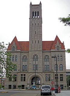
Wood County is a county in the U.S. state of West Virginia. As of the 2010 census, the population was 86,956, making it West Virginia's fifth-most populous county. Its county seat is Parkersburg. The county was formed in 1798 from the western part of Harrison County and named for James Wood, governor of Virginia from 1796 to 1799.
West Virginia is a state located in the Appalachian region in the Southern United States and is also considered to be a part of the Middle Atlantic States. It is bordered by Pennsylvania to the north, Maryland to the east and northeast, Virginia to the southeast, Kentucky to the southwest, and Ohio to the northwest. West Virginia is the 41st largest state by area, and is ranked 38th in population. The capital and largest city is Charleston.
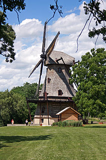
Kane County is a county in the U.S. state of Illinois. According to the 2010 census, it has a population of 515,269, making it the fifth-most populous county in Illinois. Its county seat is Geneva, and its largest city is Aurora.
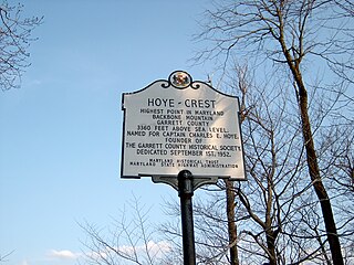
Backbone Mountain is a ridge of the Allegheny Mountains of the central Appalachian Mountain Range. It is situated in the U.S. states of West Virginia and Maryland and forms a portion of the Eastern Continental Divide. In the state of Maryland, Backbone Mountain reaches an elevation of 3,360 feet or 1,024 metres, making it Maryland’s highest point.
Kenwood may refer to:
Forest Hill is an unincorporated community in Summers County, West Virginia, United States. It lies along West Virginia Route 12 to the southeast of the city of Hinton, the county seat of Summers County. Its elevation is 1,926 feet. Although it is unincorporated, it has a post office, with the ZIP code of 24935.
The Snake Hill Wildlife Management Area is a hilly area covering 3,092 acres (1,251 ha) along the Cheat River canyon in Monongalia and Preston Counties, West Virginia. The wildlife management area is largely lies directly south of Coopers Rock State Forest, protecting the southern side of Cheat Canyon.
Mountain Lake Wilderness is a U.S. Wilderness Area in the George Washington and Jefferson National Forests. The wilderness area is located next to privately owned Mountain Lake, and consists of 8,314 acres (3,365 ha) in Virginia and 2,721 acres (1,101 ha) in West Virginia.
Bear Rock Lakes Wildlife Management Area is a 242-acre (98 ha) protected area located in Ohio County, West Virginia, about 8 miles (13 km) east of Wheeling. The terrain at Bear Rock Lakes is rolling hills covered by a combination of hardwood forest and open fields.
Sand Hill Wildlife Management Area is located near Parkersburg, West Virginia in Wood and Ritchie counties. Sand Hill WMA is located on 1,987 acres (804 ha) of rugged, hilly oak-hickory woodlands interspersed with timber, oil and gas development sites.
Forest Hills is an unincorporated community in Kanawha County, West Virginia.
Pleasant Hill is an unincorporated community in Wood County, West Virginia, United States. Pleasant Hill is located on County Route 38 5.7 miles (9.2 km) south of Parkersburg.
Red Hill is an unincorporated community in Wood County, West Virginia.
Sand Hill is an unincorporated community in Wood County, West Virginia.
Rolling Hills is an unincorporated community in Wood County, West Virginia.
Liberty Hills is an unincorporated community in Wood County, West Virginia.
Lubeck Hills is an unincorporated community in Wood County, West Virginia.
Scenic Hills is an unincorporated community in Wood County, West Virginia.
South Hills Estates is an unincorporated community in Wood County, West Virginia.
Society Hill Acres is an unincorporated community in Wood County, West Virginia.
Forest Hills, West Virginia may refer to:
Big Run is a river of 13 miles in length, located one-and-a-half miles west of Spruce Knob in Monongahela National Forest, in Pendleton County, West Virginia. It is a tributary of the North Fork South Branch Potomac River.
This article about a location in Wood County, West Virginia is a stub. You can help Wikipedia by expanding it. |