
Frederick County is located in the Commonwealth of Virginia. As of the 2010 census, the population was 78,305. Its county seat is Winchester. The county was formed in 1743 by the splitting of Orange County. It is Virginia's northernmost county.

Crystal Lake is a city in McHenry County in the U.S. state of Illinois. Named after a lake 1.6 miles (2.6 km) southwest of the city's downtown, Crystal Lake is 45 miles northwest of Chicago. The population was estimated at 39,829 in July 2019, a 2.3% decrease from 2010. Crystal Lake is the largest city in McHenry County, part of the Chicago metropolitan area.
Crystal Springs or Crystal Spring may refer to:
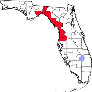
The Nature Coast is an informal, unofficial region of the U.S. state of Florida. The broadest definition of the Nature Coast includes the eight counties that abut the Gulf of Mexico along the Big Bend Coast defined by geologists: from west to east, Wakulla, Jefferson, Taylor, Dixie, Levy, Citrus, Hernando, and Pasco counties.

The Pahranagat Valley is a Tonopah Basin landform in Lincoln County, Nevada.

The Cacapon River, located in the Appalachian Mountains of West Virginia's Eastern Panhandle region, is an 81.0-mile-long (130.4 km) river known for its fishing, boating, wildlife, and scenery. As part of the Potomac River watershed, it is an American Heritage River.

The Elk River is a tributary of the Kanawha River, 172 miles (277 km) long, in central West Virginia in the United States. Via the Kanawha and Ohio rivers, it is part of the watershed of the Mississippi River.
Capon Lake is an unincorporated community in Hampshire County of West Virginia's Eastern Panhandle region. Capon Lake is situated between Yellow Spring and Intermont at the junction of West Virginia Route 259 and Capon Springs Road along the Cacapon River. Capon Springs Run empties into the Cacapon here across from the old Capon Lake Whipple Truss Bridge. Capon Lake takes its name from the Cacapon River's lake-like characteristics there. It was a popular picnic spot for tourists and travelers on the Winchester and Western Railroad.

Bubbling Spring is an unincorporated community in Hampshire County in the U.S. state of West Virginia. Bubbling Spring is situated on Cacapon River Road along the Cacapon River south of Capon Bridge and north of Hooks Mills. It takes its name from the Bubbling Spring on the Cacapon there. Bubbling Spring has been known as Bubbling Spring Camps, Cacapon Bubbling Spring Camps, and Crystal Spring.
Capon Springs Run is a 4.8-mile-long (7.7 km) tributary stream of the Cacapon River in Hampshire County of West Virginia's Eastern Panhandle. Capon Springs Run is a shallow, stony, non-navigable stream fed by the famous "Capon Springs" at its source on the flanks of Great North Mountain east of the hamlet of Capon Springs. The stream flows west through Capon Springs Resort, parallel to Capon Springs Road along Middle Ridge and meets with Himmelwright Run. To the south, Capon Springs Run is bound by the George Washington National Forest. At its confluence with Dry Run at Capon Springs Station, the stream is met by the old Winchester and Western Railroad grade where a trestle and passenger station once existed. Capon Springs Run enters the Cacapon at the old Capon Lake Whipple Truss Bridge in Capon Lake.
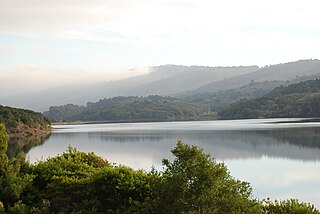
Crystal Springs Reservoir is a pair of artificial lakes located in the northern Santa Cruz Mountains of San Mateo County, California situated in the rift valley created by the San Andreas Fault just to the west of the cities of San Mateo and Hillsborough, and I-280. The lakes are part of the San Mateo Creek watershed.

San Mateo Creek is a perennial stream whose watershed includes Crystal Springs Reservoir, for which it is the only natural outlet after passing Crystal Springs Dam.

Crystal Lake is a 33-acre (130,000 m2) natural great pond located in Newton, Massachusetts. Its shores, mostly lined with private homes, also host two small parks, a designated swimming area, a town beach and a bathhouse. The public is not allowed to swim outside of the small swimming area.
The following radio stations broadcast on FM frequency 91.9 MHz:
The following radio stations broadcast on FM frequency 100.1 MHz:
Crystal Springs is an unincorporated community in Randolph County, West Virginia.

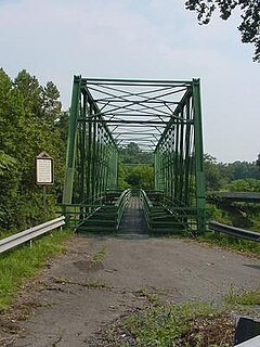
The Capon Lake Whipple Truss Bridge, formerly known as South Branch Bridge or Romney Bridge, is a historic Whipple truss bridge in Capon Lake, West Virginia. It is located off Carpers Pike and crosses the Cacapon River. The bridge formerly carried Capon Springs Road over the river, connecting Capon Springs and Capon Lake.


