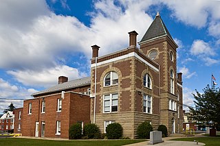
Mineral County is a county in the U.S. state of West Virginia. It is part of the Cumberland, MD-WV Metropolitan Statistical Area. As of the 2010 census, the population was 28,212. Its county seat is Keyser. The county was founded in 1866.

Scouting in West Virginia has a long history, from the 1910s to the present day, serving thousands of youth in programs that suit the environment in which they live.

The Mustang Ranch is a brothel in Storey County, Nevada, about 20 miles (32 km) east of Reno. It is currently located at 1011 Wild Horse Canyon Dr Sparks, NV 89434.

The Monongahela National Forest is a national forest located in the Allegheny Mountains of eastern West Virginia, USA. It protects over 921,000 acres of federally owned land within a 1,700,000 acres proclamation boundary that includes much of the Potomac Highlands Region and portions of 10 counties.

Henry W. Coe State Park is a state park of California, United States, preserving a vast tract of the Diablo Range. The park is located closest to the city of Morgan Hill, and is located in both Santa Clara and Stanislaus counties. The park contains over 87,000 acres (35,000 ha), making it the largest state park in northern California, and the second-largest in the state. Managed within its boundaries is a designated wilderness area of about 22,000 acres (8,900 ha). This is officially known as the Henry W. Coe State Wilderness, but locally as the Orestimba Wilderness. The 89,164-acre (36,083 ha) park was established in 1959.

The George Washington and Jefferson National Forests is an administrative entity combining two U.S. National Forests into one of the largest areas of public land in the Eastern United States. The forests cover 1.8 million acres (7,300 km2) of land in the Appalachian Mountains of Virginia, West Virginia, and Kentucky. Approximately 1 million acres (4,000 km2) of the forest are remote and undeveloped and 139,461 acres (564 km2) have been designated as wilderness areas, which eliminates future development.
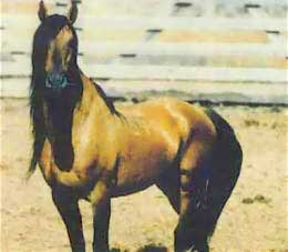
The Kiger mustang is a strain of mustang horse located in the southeastern part of the U.S. state of Oregon. Feral horses with specific conformation traits discovered in 1977, the name applies only to wild-captured individuals and does not apply to their bred-in-captivity progeny, which are known as Kiger horses. The Bureau of Land Management (BLM) administers two herd management areas for Kiger mustangs in the Burns District—Kiger and Riddle Mountain, in the Steens Mountain area. DNA testing has shown that Kiger mustangs are descended largely from Spanish horses brought to North America in the 17th century, a bloodline thought to have largely disappeared from mustang herds before the Kiger horses were found.
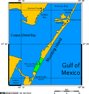
Mustang Island is a barrier island on the Gulf Coast of Texas in the United States. The island is 18 miles (29 km) long, stretching from Corpus Christi to Port Aransas. The island is oriented generally northeast–southwest, with the Gulf of Mexico on the east and south, and Corpus Christi Bay on the north and west. The island's southern end connects by roadway to Padre Island. At the northern end of the island is Port Aransas, beyond which is San José Island. The Aransas Channel, also known as the "Aransas Pass," which separates Mustang Island from San José Island, is protected by jetties extending into the Gulf from each island.

The West Virginia National Guard is a part of the West Virginia Department of Military Affairs and Public Safety. It comprises the West Virginia Army National Guard and the West Virginia Air National Guard.

Blackwater Falls State Park is located in the Allegheny Mountains of Tucker County, West Virginia, USA. The centerpiece of the park is Blackwater Falls, a 62-foot (19 m) cascade where the Blackwater River leaves its leisurely course in Canaan Valley and enters rugged Blackwater Canyon. It is among the most photographed venues in the state and appears on calendars, stationery, and advertisements. The river is named for its tannin-darkened water.

The West Virginia Air National Guard is the aerial militia of the State of West Virginia, United States of America. It is, along with the West Virginia Army National Guard, an element of the West Virginia National Guard.
John West was acting colonial Governor of Virginia from 1635 to 1637, the third West brother to serve as Governor.
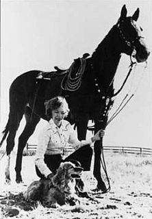
Velma Bronn Johnston, also known as Wild Horse Annie, was an animal welfare activist. She led a campaign to stop the eradication of mustangs and free-roaming burros from public lands. She was instrumental in passing legislation to stop using aircraft and land vehicles from inhumanely capturing wild horses and burros.

Big Ditch Wildlife Management Area is a protected area located in Webster County, West Virginia near the town of Cowen. The WMA is 388 acres (157 ha) in size and is centered on Big Ditch Lake, a 55-acre (22 ha) man-made reservoir.
The 167th Airlift Squadron is a unit of the West Virginia Air National Guard 167th Airlift Wing located at Shepherd Field Air National Guard Base, Martinsburg, West Virginia. It is equipped with the C-17 Globemaster III, heavy airlifter.

Berwind Lake Wildlife Management Area is located on 85 acres (340,000 m2) near War in McDowell County, West Virginia. The wildlife management area is centered on 20-acre (81,000 m2) Berwind Lake.

Bear Rock Lakes Wildlife Management Area is a 242-acre (98 ha) protected area located in Ohio County, West Virginia, about 8 miles (13 km) east of Wheeling. The terrain at Bear Rock Lakes is rolling hills covered by a combination of hardwood forest and open fields.

Sleepy Creek Wildlife Management Area is located in Morgan and Berkeley Counties in West Virginia's Eastern Panhandle. It encompasses 22,928 acres (92.79 km2), mostly covered with mixed oak and pine forest, although about 3,500 acres (14 km2) are covered with mixed hardwoods. The 205-acre (83 ha) Sleepy Creek Lake is located entirely within the WMA.

Southwestern Energy is a natural gas exploration and production company organized in Delaware and headquartered in Spring, Texas. The company is ranked 776th on the Fortune 500.

The SMU Mustangs football statistical leaders are individual statistical leaders of the SMU Mustangs football program in various categories, including passing, rushing, receiving, total offense, defensive stats, and kicking. Within those areas, the lists identify single-game, single-season, and career leaders. The Mustangs represent Southern Methodist University in the NCAA's American Athletic Conference.


