
Frederick County is located in the Commonwealth of Virginia. As of the 2010 census, the population was 78,305. Its county seat is Winchester. The county was formed in 1743 by the splitting of Orange County. It is Virginia's northernmost county.

Charleston is the capital and most populous city of the U.S. state of West Virginia. Located at the confluence of the Elk and Kanawha rivers, the city had a population of 51,400 at the 2010 census and an estimated population of 46,536 in 2019. The Charleston metropolitan area as a whole had an estimated 208,089 residents in 2019. Charleston is the center of government, commerce, and industry for Kanawha County, of which it is the county seat.
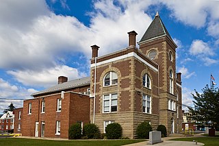
Mineral County is a county in the U.S. state of West Virginia. It is part of the Cumberland, MD-WV Metropolitan Statistical Area. As of the 2010 census, the population was 28,212. Its county seat is Keyser. The county was founded in 1866.
Lee County is the westernmost county in the U.S. Commonwealth of Virginia. As of the 2018 census estimate, the population was 23,541. Its county seat is Jonesville.

Bath County is a United States county on the central western border of the Commonwealth of Virginia, on the West Virginia state line. As of the 2010 census, the population was 4,731. In 2018, the population was estimated at 4,292; it is the second-least populous county in Virginia. Bath's county seat is Warm Springs.
Scouting in Virginia has a long history, from the 1910s to the present day, serving thousands of youth in programs that suit the environment in which they live. Many of the local groups and districts took names of historic Virginia Indian tribes in the state.

Scouting in West Virginia has a long history, from the 1910s to the present day, serving thousands of youth in programs that suit the environment in which they live.

Hinsdale is a village in Cook and DuPage counties in the U.S. state of Illinois. Hinsdale is a western suburb of Chicago. The population was 16,816 at the 2010 census, most of whom lived in DuPage County. The town's ZIP code is 60521, which is listed in the top 1% of wealthiest towns in Illinois as well as the sixth-wealthiest ZIP code in the United States among areas with a population of 20,000 or more. The town has a rolling, wooded topography, with a downtown, and is a 22-minute express train ride to downtown Chicago on the Burlington Northern line.
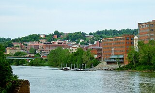
Morgantown is the county seat of Monongalia County, West Virginia, United States, situated along the Monongahela River. West Virginia University is located in the city. The population was 29,660 at the 2010 Census Bureau, making Morgantown the largest city in North-Central West Virginia. The Morgantown metropolitan area has a population of 138,176.

The Appomattox Court House National Historical Park is a preserved 19th-century village in Appomattox County, Virginia. The village is famous for the site of the Battle of Appomattox Court House, and contains the house of Wilmer McLean, where the surrender of the Army of Northern Virginia under Robert E. Lee to Union commander Ulysses S. Grant took place on April 9, 1865, effectively ending the American Civil War. The McLean House was the site of the surrender conference, but the village itself is named for the presence nearby of what is now preserved as the Old Appomattox Court House.

The Monongahela National Forest is a national forest located in the Allegheny Mountains of eastern West Virginia, USA. It protects over 921,000 acres of federally owned land within a 1,700,000 acres proclamation boundary that includes much of the Potomac Highlands Region and portions of 10 counties.

The Eastern Panhandle is the eastern of the two panhandles in the U.S. state of West Virginia. It is a small stretch of territory in the northeast of the state, bordering Maryland and Virginia. Some sources and regional associations only identify the Eastern Panhandle as being composed of Morgan, Berkeley, and Jefferson counties. Berkeley and Jefferson counties are geographically located in the Shenandoah Valley. West Virginia is the only U.S. state with two panhandles; the other is the Northern Panhandle.
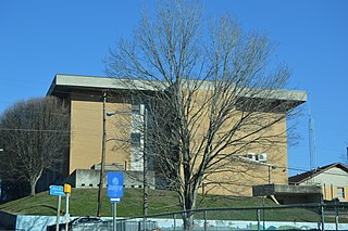
Potomac State College is a public college in Keyser, West Virginia. It is part of the West Virginia University system. Potomac State College is located approximately 90 miles east of West Virginia University's campus in Morgantown, West Virginia.
Mineral rights are property rights to exploit an area for the minerals it harbors. Mineral rights can be separate from property ownership. Mineral rights can refer to sedentary minerals that do not move below the Earth's surface or fluid minerals such as oil or natural gas. There are three major types of mineral property; unified estate, severed or split estate, and fractional ownership of minerals.
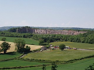
Dulcote Quarry is a disused limestone quarry at Dulcote, near Wells on the Mendip Hills, Somerset, England. The quarry measures around 600 metres (2,000 ft) from West to East and around 350 metres (1,150 ft) from North to South, with an area of 18 acres (7.3 ha), which is surrounded by 80 acres (32 ha) of woodland.

Paint Bank is an unincorporated community in northern Craig County, Virginia, United States. It is located at the intersection of State Route 18 and State Route 311 northwest of the town of New Castle, the county seat. The village is located between Potts Mountain and Peters Mountain.

The James River Face Wilderness is an 8,907-acre area located near Natural Bridge, Virginia that is protected by the Eastern Wilderness Act of Congress to maintain its present, natural condition. As part of the National Wilderness Preservation System, it helps to preserve a variety of natural life forms and contributes to a diversity of plant and animal gene pools. Over half of the ecosystems in the United States exist within designated wilderness.

Mattaponi Wildlife Management Area is a 2,542-acre (10.29 km2) Wildlife Management Area (WMA) in Caroline County, Virginia. Located west of Bowling Green, the area protects a mixture of wetlands and upland forests at the confluence of the Mattaponi and South rivers.

Waggener Magisterial District is one of ten magisterial districts in Mason County, West Virginia, United States. The district was originally established as a civil township in 1863, and converted into a magisterial district in 1872. In 2010, Waggener District was home to 2,720 people.


