
The Blue Ridge Mountains are a physiographic province of the larger Appalachian Mountains range. The mountain range is located in the eastern United States, and extends 550-mile (890 km) southwest from southern Pennsylvania through Maryland, West Virginia, Virginia, North Carolina, South Carolina, Tennessee, and Georgia. This province consists of northern and southern physiographic regions, which divide near the Roanoke River gap. To the west of the Blue Ridge, between it and the bulk of the Appalachians, lies the Great Appalachian Valley, bordered on the west by the Ridge and Valley province of the Appalachian range.

The John Muir Wilderness is a wilderness area that extends along the crest of the Sierra Nevada of California for 90 miles (140 km), in the Inyo and Sierra National Forests. Established in 1964 by the Wilderness Act and named for naturalist John Muir, it contains 581,000 acres (2,350 km2). The wilderness lies along the eastern escarpment of the Sierra from near Mammoth Lakes and Devils Postpile National Monument in the north, to Cottonwood Pass near Mount Whitney in the south. The wilderness area also spans the Sierra crest north of Kings Canyon National Park, and extends on the west side of the park down to the Monarch Wilderness.

The Cumberland Mountains are a mountain range in the southeastern section of the Appalachian Mountains. They are located in western Virginia, southwestern West Virginia, eastern edges of Kentucky, and eastern middle Tennessee, including the Crab Orchard Mountains. Their highest peak, with an elevation of 4,223 feet (1,287 m) above mean sea level, is High Knob, which is located near Norton, Virginia.

The Allegheny Front is the major southeast- or east-facing escarpment in the Allegheny Mountains in southern Pennsylvania, western Maryland, and eastern West Virginia, USA. The Allegheny Front forms the boundary between the Ridge-and-Valley Appalachians to its east and the Appalachian Plateau to its west. The Front is closely associated with the Appalachian Mountains' Eastern Continental Divide, which in this area divides the waters of the Ohio/Mississippi river system, flowing to the Gulf of Mexico, from rivers flowing into Chesapeake Bay and from there into the Atlantic Ocean.

David Lynn Selby is an American film, television and stage actor. He is best known for playing Quentin Collins in the daytime soap opera Dark Shadows (1968–71), and Richard Channing in the prime-time soap opera Falcon Crest (1982–90). Selby also had prominent roles in the television series Flamingo Road (1981–82), and the feature film Raise the Titanic (1980). Also a published writer, Selby has written several books including novels, memoirs, and collections of poetry.

Jennings Randolph Lake is a reservoir of 952 acres (3.85 km2) located on the North Branch Potomac River in Garrett County, Maryland and Mineral County, West Virginia. It is approximately eight miles upstream of Bloomington, Maryland, and approximately five miles north of Elk Garden, West Virginia.

Shenandoah Mountain is a mountain ridge approximately 73 miles (117 km) long in Virginia and West Virginia. The steep, narrow, sandstone-capped ridge extends from northern Bath County, Virginia to southern Hardy County, West Virginia. Along the way, its crest defines the borders between Highland and Augusta counties, Virginia, and between Pendleton County, West Virginia, and Rockingham County, Virginia. The name comes from the Iroquoian word for 'deer'.
The 201st Field Artillery Regiment is a West Virginia Army National Guard regiment. Based in Fairmont, West Virginia, it currently perpetuates the Virginia elements of the Maryland and Virginia Rifle Regiment, which fought in the American Revolution. Organized in 1735, it is the oldest regiment in the U.S. Army still active today. Units also saw action on both sides of the American Civil War, with many companies of the regiment combined to form the Union Army's 1st West Virginia Infantry.

Blue Ridge Mountain, also known as Blue Mountain, is the colloquial name of the westernmost ridge of the Blue Ridge Mountains in northern Virginia and the Eastern Panhandle of West Virginia. The Appalachian Trail traverses the entire length of the mountain along its western slope and crest.

Twin Lakes State Park is a state park in Virginia. It is located in Central Virginia in Prince Edward County.

Reddish Knob of Shenandoah Mountain is one of the highest points in Virginia, rising 4,397 feet (1,340 m). A narrow, paved road reaches the summit from Harrisonburg, Virginia.
The Tennessee Valley Divide is the boundary of the drainage basin of the Tennessee River and its tributaries.

The Silurian Tuscarora Formation — also known as Tuscarora Sandstone or Tuscarora Quartzite — is a mapped bedrock unit in Pennsylvania, Maryland, West Virginia, and Virginia, USA.

Clan MacQueen is a Highland Scottish clan and a member of the Chattan Confederation. The clan does not currently have a chief and is therefore considered an Armigerous clan.
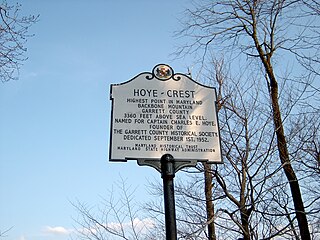
Hoye-Crest is a summit along Backbone Mountain just inside of Garrett County, Maryland. It is the highest natural point in Maryland at an elevation of 3,360 feet (1,020 m).

T. M. Gathright Wildlife Management Area is a 13,428-acre (54.34 km2) Wildlife Management Area (WMA) in Bath County, Virginia. The property's mountainous terrain includes elevations ranging from 1,400 to 3,600 feet above sea level, and is divided by 2,530-acre (10.2 km2) Lake Moomaw. The northwest boundary is marked at the crest of Allegheny Mountain, along the border between Virginia and West Virginia; additional mountains include Bolar Mountain to the west of the lake, and Coles Mountain to its east. A number of streams flow eastward from the summit, terminating at Mill Creek. The primary habitat is upland hardwood forest including mixed stands of oak and hickory, with tulip poplar in some of the more fertile areas. Small non-forested openings are also maintained for the benefit of wildlife.

Peters Mountain is a 52-mile (84 km) mountain in the U.S. states of Virginia and West Virginia. It is located on the border between Alleghany County, VA, Monroe County, WV, Giles Co.,VA, and Craig Co.,VA. Its elevation ranges from 4,073 feet (1,241 m) on the mountaintop to a low of 2,300 feet (700 m). It produces some of the water supply for Monroe County.

Flat Top is an unincorporated community in Mercer County, West Virginia, United States. Flat Top is located on U.S. Route 19 19 miles (31 km) south of Beckley.
The Triple Crown of Hiking informally refers to the three major U.S. long-distance hiking trails:

Silver Lake is an unincorporated community in Preston County, West Virginia, United States. Silver Lake is located along U.S. Route 219 7.5 miles (12.1 km) north of Thomas in Tucker County.


