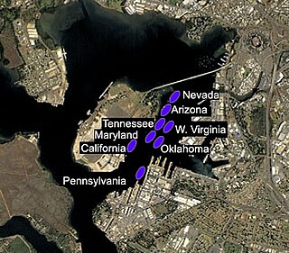
Battleship Row was the grouping of eight U.S. battleships in port at Pearl Harbor, Hawaii, when the Japanese attacked on 7 December 1941. These ships bore the brunt of the Japanese assault. They were moored next to Ford Island when the attack commenced. The ships were Arizona, California, Maryland, Nevada, Oklahoma, Pennsylvania, Tennessee, and West Virginia. A repair ship, Vestal, was also present, moored next to Arizona.
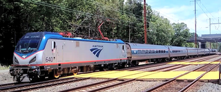
The Silver Star is a 1,522-mile (2,449 km) passenger train route in the Silver Service brand operated by Amtrak, running from New York City south to Miami, Florida via the Northeast Corridor to Washington, D.C., then via Richmond, Virginia; Raleigh, North Carolina; Columbia, South Carolina; Savannah, Georgia; Jacksonville, Florida; Orlando, Florida; and Tampa, Florida.

The Western Maryland Railway was an American Class I railroad (1852–1983) which operated in Maryland, West Virginia, and Pennsylvania. It was primarily a coal hauling and freight railroad, with a small passenger train operation.
The Richmond and Alleghany Railroad was built along the James River along the route of the James River and Kanawha Canal from Richmond on the Fall Line at the head of navigation to a point west of Lynchburg near Buchanan, Virginia, and combined with the Buchanan and Clifton Forge Railway Company to reach Clifton Forge, Virginia.

The Mountain Subdivision is a railroad line owned and operated by CSX Transportation in the U.S. states of Maryland and West Virginia. The line runs from Cumberland, Maryland, west to Grafton, West Virginia, along the original Baltimore and Ohio Rail Road (B&O) main line. It was known as the West End Subdivision until the B&O's absorption into the Chessie System, and included the B&O's original crossing of the Allegheny Mountains. Through CSX traffic to the west from Cumberland now uses the Keystone Subdivision over Sand Patch Grade.

The Cumberland Subdivision is a railroad line owned and operated by CSX Transportation in the U.S. states of Maryland and West Virginia. The line runs from Brunswick, Maryland, west to Cumberland, Maryland, along the old Baltimore and Ohio Rail Road (B&O) main line. At its east end, the Cumberland Subdivision becomes the Metropolitan Subdivision; at its west end at Cumberland, Maryland it becomes the Cumberland Terminal Subdivision. It meets the Shenandoah Subdivision at Harpers Ferry, West Virginia, and the Lurgan Subdivision at Cherry Run, West Virginia.

The CA postcode area, also known as the Carlisle postcode area, is a group of 28 postcode districts in north-west England, which are subdivisions of 22 post towns. These cover northern and central Cumbria, including Carlisle, Penrith, Workington, Whitehaven, Maryport, Cockermouth, Egremont, Alston, Appleby-in-Westmorland, Beckermet, Brampton, Cleator, Cleator Moor, Frizington, Holmrook, Keswick, Kirkby Stephen, Moor Row, Ravenglass, Seascale, St Bees and Wigton, plus a very small part of Northumberland.

Sambrial, is a town of Sialkot District in the Punjab province of Pakistan. It is the capital of Sambrial Tehsil, an administrative subdivision of the district.

Cottageville is an unincorporated community in western Jackson County, West Virginia, United States. It lies along West Virginia Route 331 northwest of the city of Ripley, the county seat of Jackson County. Established in 1858, its elevation is 594 feet (181 m). Although Cottageville is unincorporated, it has a post office, with the ZIP code of 25239. It also is the site of the annual Jackson County Junior Fair. Michael Coleman, a well known early Indian fighter, was killed and buried in the area, according to a historical marker placed by the state of WV. The wooden Grist Mill located here since the 1840s burned to the ground in the summer of 1965. Its foundation stones remain. It had remained in operation full-time until 1930, part-time until 1937. Cottageville was a commercial center with a bank, newspaper, tannery, blacksmith, several stores, a railroad station on the B & O and many other businesses in the early part of the twentieth century. Its heyday faded with the closing of the mill and the improvement of roads in the county. The B & O pulled up its tracks to the county seat, Ripley, in the mid-nineteen-sixties. Less than a mile from the old town, the county operated what folks called the "poor farm," an early version of a welfare commune. That closed in the thirties with the New Deal. That land is now the Jackson County Junior Fairgrounds.

Key West is both a subdivision in Albemarle County, Virginia and a historic home that formerly served as a place name for the community. The Key West estate was owned by the Minors, a prominent and wealthy family, before much of the land was sold off to become the Key West subdivision. The house still stands.

Kay Moor, also known as Kaymoor, is the site of an abandoned coal mine, coal processing plant and coal town near Fayetteville, West Virginia. The town site is located in the New River Gorge at Kaymoor Bottom (38°03′00″N81°03′17″W). It is linked to the mine portal 560 feet (170 m) above on Sewell Bench (38°02′52″N81°03′58″W) in the wall of the Gorge by conveyors.
The Devonian Scherr Formation is a mapped bedrock unit in Pennsylvania, Maryland, Virginia and West Virginia.
Hughs Subdivision is an unincorporated community in Wood County, West Virginia.
Parish-Morris Subdivision is an unincorporated community in Wood County, West Virginia.
Wells Subdivision is an unincorporated community in Wood County, West Virginia.
Lockgreen is an upper-class gated community located in Richmond, Virginia's West End. The neighborhood lies within Wilton and is served by Lockgreen Circle. Lockgreen was built as an extension to Windsor Farms's Old Locke subdivision. The zip code for the subdivision is 23226.

Moor Green is a historic home located near Brentsville, Prince William County, Virginia. It dates to the early-19th century, and is a two-story, five-bay, Federal style brick residence, with a one-room, two-story ell. It has a standing seam metal gable roof and a single-pile, central-passage plan.
The Florence Division is a railroad division operated by CSX Transportation in the U.S. states of Georgia, Kentucky, North Carolina, South Carolina, Tennessee, Virginia & West Virginia. The Florence Division has 60 Subdivisions. The Subdivisions in italics came from the Huntington East & Huntington West Divisions effective June 20, 2016.


