Waverley, Queensland

Last updated

Waverley
Queensland
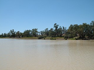
Landscape beside the Boulia Mount Isa Highway, Waverley, Shire of Boulia, 2019.jpg
Landscape beside the Boulia Mount Isa Highway, 2019
Australia Queensland location map.svg
Red pog.svg
Waverley
Coordinates 21°34′36″S139°00′33″E / 21.5768°S 139.0092°E / -21.5768; 139.0092 (Waverley (centre of locality))
Population6 (SAL 2021) [1]
Postcode(s) 4825
Area9,244.8 km2 (3,569.4 sq mi)
Time zone AEST (UTC+10:00)
Location
LGA(s) Shire of Boulia
State electorate(s) Gregory
Federal division(s) Kennedy
Suburbs around Waverley:
Barkly Mount Isa (locality) Duchess
Piturie Waverley Dajarra
Carrandotta Georgina Buckingham

Waverley is an outback locality in the Shire of Boulia, Queensland, Australia. [2] In the 2021 census, Waverley had a population of 6 people. [3]

Contents

Geography

Waverley is in the Channel Country. All watercourses in this area are part of the Lake Eyre drainage basin, [4] and most will dry up before their water reaches Lake Eyre. [5]

The predominant land use is grazing on native vegetation. [4]

The Boulia Mount Isa Highway enters the locality from the north-east (Mount Isa) and exits to the east (Dajarra). [4]

Waverley has the following mountains (from north to south):

History

Moonah Creek Hanging Tree, 1964 Moonah Creek 'Hanging Tree' (1964).jpg
Moonah Creek Hanging Tree, 1964

In the 2016 census, Waverley had a population of 20 people. [12]

In the 2021 census, Waverley had a population of 6 people. [3]

Heritage listings

Waverley has a number of heritage-listed sites, including:

Education

There are no schools in Waverley. The nearest primary schools are in Mount Isa and Dajarra but might be infeasible for a daily commute. [4] The nearest secondary school is in Mount Isa. [4] The Spinifex State College in Mount Isa offers boarding facilities. [14] Other boarding schools or distance education would be options.

Economy

There are a number of homesteads in the locality (from north to south): [15]

Related Research Articles

<span class="mw-page-title-main">Boulia, Queensland</span> Town in Queensland, Australia

Boulia is an outback town and locality in the Shire of Boulia, Queensland, Australia. In the 2016 census, Boulia had a population of 301 people.

<span class="mw-page-title-main">Camooweal</span> Town in Queensland, Australia

Camooweal is an outback town and locality in the City of Mount Isa, Queensland, Australia. The locality is on the Queensland border with the Northern Territory. In the 2021 census, the locality of Camooweal had a population of 236 people.

<span class="mw-page-title-main">Dajarra, Queensland</span> Town in Queensland, Australia

Dajarra is a town and a locality in the Shire of Cloncurry, Queensland, Australia. In the 2016 census, Dajarra had a population of 191 people; 60.3% of the population are Indigenous.

<span class="mw-page-title-main">Cameron Corner, Queensland</span> Suburb of Bulloo Shire, Queensland, Australia

Cameron Corner is an outback locality in the Shire of Bulloo, Queensland, Australia. It is on the Queensland border with New South Wales to the south and South Australia to the west. In the 2021 census, Cameron Corner had a population of 19 people.

<span class="mw-page-title-main">Gregory, Queensland</span> Town in Queensland, Australia

Gregory is an outback town and locality in the Shire of Burke, Queensland, Australia. In the 2016 census, the locality of Gregory had a population of 72 people.

Gilbert River is a rural locality in the Shire of Etheridge, Queensland, Australia. In the 2021 census, Gilbert River had a population of 32 people.

Dajarra and Selwyn Branch Railways were lines in north-west Queensland, Australia. Along with the Mount Cuthbert and Dobbyn Branch Railways, they were essentially built to tap large deposits of copper discovered in the Cloncurry region.

<span class="mw-page-title-main">Torrens Creek</span> Town in Queensland, Australia

Torrens Creek is a rural town and locality in the Shire of Flinders, Queensland, Australia. In the 2016 census the locality of Torrens Creek had a population of 70 people.

<span class="mw-page-title-main">Stamford, Queensland</span> Town in Queensland, Australia

Stamford is a rural town and locality in the Shire of Flinders, Queensland, Australia. In the 2016 census, the locality of Stamford had a population of 43 people.

<span class="mw-page-title-main">Duchess, Queensland</span> Town in Queensland, Australia

Duchess is a rural town and locality in the Shire of Cloncurry, Queensland, Australia. In the 2016 census, Duchess had a population of 23 people.
<span class="mw-page-title-main">Durham, Queensland</span> Suburb of Bulloo Shire, Queensland, Australia

Durham is a rural locality in the Shire of Bulloo, Queensland, Australia. It is on the Queensland border with South Australia. In the 2021 census, Durham had a population of 31 people.

<span class="mw-page-title-main">Lawn Hill, Queensland</span> Suburb of Shire of Burke, Queensland, Australia

Lawn Hill is an outback locality split between the Shire of Burke and the City of Mount Isa in Queensland, Australia. The locality is on the Queensland border with the Northern Territory. In the 2021 census, Lawn Hill had a population of 63 people.

<span class="mw-page-title-main">Tanbar, Queensland</span> Suburb of Shire of Barcoo, Queensland, Australia

Tanbar is an outback locality in the Shire of Barcoo, Queensland, Australia. It is on the corner of Queensland's southern and western border with South Australia. In the 2021 census, Tanbar had "no people or a very low population".

<span class="mw-page-title-main">Gunpowder, Queensland</span> Town in Queensland, Australia

Gunpowder is an outback town and locality in the City of Mount Isa, Queensland, Australia. In the 2016 census, Gunpowder had a population of 43 people.

Strathmore is a locality split between the Shire of Mareeba and the Shire of Etheridge, in Queensland, Australia. In the 2021 census, Strathmore had "no people or a very low population".

Desailly is a rural locality in the Shire of Mareeba, Queensland, Australia. In the 2021 census, Desailly had "no people or a very low population".

<span class="mw-page-title-main">Amaroo, Queensland</span> Suburb of Shire of Boulia, Queensland, Australia

Amaroo is an outback locality split between the Shire of Boulia and the Shire of Diamantina, both in Central Western Queensland, Australia. In the 2021 census, Amaroo had a population of 17 people.

<span class="mw-page-title-main">Lyndhurst, Queensland</span> Suburb of Shire of Etheridge, Queensland, Australia

Lyndhurst is a rural locality in the Shire of Etheridge, Queensland, Australia. In the 2021 census, Lyndhurst had a population of 11 people.

Sujeewong is a rural locality in the Western Downs Region, Queensland, Australia. In the 2021 census, Sujeewong had "no people or a very low population".

<span class="mw-page-title-main">Barkly, Queensland</span> Suburb of City of Mount Isa, Queensland, Australia

Barkly is an outback locality in the City of Mount Isa, Queensland, Australia. The locality is on the Queensland border with Northern Territory. In the 2021 census, Barkly had a population of 25 people.

References

  1. Australian Bureau of Statistics (28 June 2022). "Waverley (Qld) (suburb and locality)". Australian Census 2021 QuickStats. Retrieved 28 June 2022.  OOjs UI icon edit-ltr-progressive.svg
  2. "Waverley – locality in Shire of Boulia (entry 42348)". Queensland Place Names. Queensland Government . Retrieved 10 June 2019.
  3. 1 2 Australian Bureau of Statistics (28 June 2022). "Waverley (SAL)". 2021 Census QuickStats. Retrieved 28 February 2023. OOjs UI icon edit-ltr-progressive.svg
  4. 1 2 3 4 5 "Queensland Globe". State of Queensland . Retrieved 31 May 2023.
  5. FitzSimons, Trish (2010). "Channel Country". Queensland Historical Atlas. University of Queensland. Archived from the original on 15 August 2019. Retrieved 15 August 2019.
  6. 1 2 3 4 5 6 "Mountain peaks and capes - Queensland". Queensland Open Data. Queensland Government. 12 November 2020. Archived from the original on 25 November 2020. Retrieved 25 November 2020.
  7. "Mount Guide – mountain in Boulia Shire (entry 14937)". Queensland Place Names. Queensland Government . Retrieved 25 November 2020.
  8. "Mount Woodhouse – mountain in Boulia Shire (entry 37979)". Queensland Place Names. Queensland Government . Retrieved 25 November 2020.
  9. "Pinnacle Knob – mountain in Boulia Shire (entry 26935)". Queensland Place Names. Queensland Government . Retrieved 25 November 2020.
  10. "Steamboat Hill – mountain in Boulia Shire (entry 32309)". Queensland Place Names. Queensland Government . Retrieved 25 November 2020.
  11. "McCabe Knob – mountain in Boulia Shire (entry 21301)". Queensland Place Names. Queensland Government . Retrieved 25 November 2020.
  12. Australian Bureau of Statistics (27 June 2017). "Waverley (SSC)". 2016 Census QuickStats. Retrieved 20 October 2018. OOjs UI icon edit-ltr-progressive.svg
  13. "Moonah Creek 'Hanging Tree' (entry 600040)". Queensland Heritage Register . Queensland Heritage Council. Retrieved 7 July 2013.
  14. "Residential Campus" (PDF). Spinifex State College . 2015. Archived (PDF) from the original on 15 August 2019. Retrieved 15 August 2019.
  15. "Homesteads - Queensland". Queensland Open Data. Queensland Government. 18 November 2020. Archived from the original on 24 November 2020. Retrieved 24 November 2020.