Mount Isa (locality), Queensland

Last updated

Mount Isa (locality)
Queensland
Australia Queensland location map.svg
Red pog.svg
Mount Isa (locality)
Coordinates 20°43′32″S139°28′14″E / 20.7256°S 139.4705°E / -20.7256; 139.4705
Population118 (2016 census) [1]
 • Density0.01670/km2 (0.04325/sq mi)
Postcode(s) 4825
Area7,065.9 km2 (2,728.2 sq mi)
Time zone AEST (UTC+10:00)
LGA(s) City of Mount Isa
State electorate(s) Traeger
Federal division(s) Kennedy
Localities around Mount Isa (locality):
Barkly Gunpowder Three Rivers
Barkly Mount Isa (locality) Cloncurry
Barkly Waverley Duchess

Mount Isa is a rural locality in the City of Mount Isa, Queensland, Australia. [2] It is the land that surrounds (and excludes) the suburbs of the town of Mount Isa. In the 2016 census, the locality of Mount Isa had a population of 118 people. [1]

Contents

Geography

The shape of the locality can be loosely be described as a doughnut (torus) where the "hole" is the excluded urban area of Mount Isa, consisting of the suburbs (from north to south): Kalkadoon, Lanskey, Ryan, Soldiers Hill, Winston, Sunset, Menzies, Pioneer, Miles End, Fisher, The Gap, Mount Isa City, Breakaway, Townview, Parkside, Mornington, Healy, Happy Valley, Mica Creek and Spreadborough. [3]

The Mount Isa Mines facility is in the locality immediately west of the suburbs (from north to south): Kalkdoon, Soldiers Hill, Miles End, Parkside, Happy Valley and Mica Creek. [3]

The suburbs are separated from the mine facility by the Mount Isa railway line with the Mount Isa railway station in Station Street, Miles End ( 20°43′35″S139°29′05″E / 20.7265°S 139.4847°E / -20.7265; 139.4847 (Mount Isa railway station) ), [4] almost on the boundary between that suburb and the Mount Isa locality and the mine facility. [3] The railway line exits the urban area at Mica Creek. Although the line is heading to Cloncurry to the east, the line travels south and exits the locality via Waverley, and then passes through Duchess and Kuridala. This indirect route is to avoid the Mount Godwin Range. [3]

The Barkly Highway enter the locality from the west (Cloncurry), passes through the Mount Godwin Range and enters the urban area at Breakway. It exits the urban area at Kalkadoon and continues north, exiting the locality at Gunpowder. The Mount Isa Duchess Road exits the urban area at Spreadborough and travels south-east exiting the locality at Duchess. The Boulia Mount Isa Highway commences just west of Mica Creek and travels south exiting the locality at Waverley. [3]

History

The locality takes its name from the city, the name of which was suggested by prospector John Campbell Miles who established the first mineral lease in the area in February 1923. It is thought to be a corruption of Mount Ida, the mining town in Western Australia. [2]

Education

There are no schools in the locality of Mount Isa, but there is a range of primary and secondary schools within the suburbs of Mount Isa. [3]

Related Research Articles

<span class="mw-page-title-main">Mount Isa</span> City in Queensland, Australia

Mount Isa is a city in the Gulf Country region of Queensland, Australia. It came into existence because of the vast mineral deposits found in the area. Mount Isa Mines (MIM) is one of the most productive single mines in world history, based on combined production of lead, silver, copper and zinc.

<span class="mw-page-title-main">City of Mount Isa</span> Local government area in Queensland, Australia

The City of Mount Isa is a local government area in north west Queensland. The City covers the urban locality of Mount Isa, the administrative centre, and surrounding area, sharing a boundary with the Northern Territory to the west.

<span class="mw-page-title-main">Dajarra, Queensland</span> Town in Queensland, Australia

Dajarra is a town and a locality in the Shire of Cloncurry, Queensland, Australia. In the 2016 census, Dajarra had a population of 191 people; 60.3% of the population are Indigenous.

The Kalkadoon are descendants of an Indigenous Australian tribe living in the Mount Isa region of Queensland. Their forefather tribe has been called "the elite of the Aboriginal warriors of Queensland". In 1884 they were massacred at "Battle Mountain" by settlers and police.

<span class="mw-page-title-main">Spinifex State College</span> Public, day and boarding school in Mount Isa, Queensland, Australia

Spinifex State College is a public, co-educational, day and boarding school located in Mount Isa, Queensland. It first opened in 2003.

The Selwyn Range is a rugged mountain range near Mount Isa and Cloncurry in north-west Queensland, Australia, composed largely of Proterozoic metamorphic rocks. It is drained in the north by the Williams and Fullarton rivers, which run into the Gulf of Carpentaria, and in the south by the McKinlay River and its tributary, Boorama Creek which drain also into the Gulf of Carpentaria. The area is heavily mineralised, containing copper, gold, lead, and zinc, and is important for mining.

Ballara is the site of a deserted mining town in the locality of Kuridala in north-western Queensland, Australia, in the Selwyn Range between the towns of Mount Isa and Cloncurry. It is within the local government area of Shire of Cloncurry.

Dajarra and Selwyn Branch Railways were lines in north-west Queensland, Australia. Along with the Mount Cuthbert and Dobbyn Branch Railways, they were essentially built to tap large deposits of copper discovered in the Cloncurry region.

<span class="mw-page-title-main">Great Northern Railway (Mt Isa line)</span>

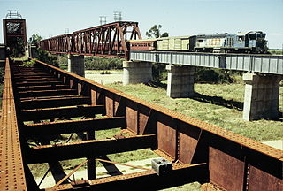
The Great Northern Railway is a 1067 mm gauge railway line in Queensland, Australia. The line stretches nearly 1,000 kilometres linking the port city of Townsville, Australia to the mining town of Mount Isa in north-west Queensland. Along with a passenger service called the Inlander, it is a major freight route connecting the Mount Isa Mines to the Port of Townsville. In 2010, the line moved 5.8 million tonnes of cargo, and this is expected to increase significantly in coming years.

John Campbell Miles was an Australian prospector and pastoral worker who discovered the mineralisation upon which the Mount Isa Mines were established in Queensland.

<span class="mw-page-title-main">Duchess, Queensland</span> Town in Queensland, Australia

Duchess is a rural town and locality in the Shire of Cloncurry, Queensland, Australia. In the 2016 census, Duchess had a population of 23 people.

Selwyn is a rural town and locality in the Shire of Cloncurry, Queensland, Australia. Selwyn is now an abandoned mining town. In the 2016 census the locality of Selwyn had a population of 50 people.

<span class="mw-page-title-main">Mount Cuthbert Township and Smelter</span> Historic site in Queensland, Australia

Mount Cuthbert Township and Smelter is a heritage-listed mining camp north-west of Kajabbi Township, Three Rivers, Shire of Cloncurry, Queensland, Australia. It was built from c. 1908 to c. 1925. It is also known as Kalkadoon Mine & Winding Plant, Mount Cuthbert Mine & Smelter, and Mount Cuthbert Township & Railway Formation. It was added to the Queensland Heritage Register on 25 May 2004.

Parkside is a suburb of Mount Isa in the City of Mount Isa, Queensland, Australia. In the 2016 census, Parkside had a population of 1,532 people.

<span class="mw-page-title-main">Mount Isa Mine Early Infrastructure</span> Historic site in Queensland, Australia

Mount Isa Mine Early Infrastructure is a heritage-listed group of mining infrastructure on the Mount Isa Mine Lease, Mount Isa (locality), City of Mount Isa, Queensland, Australia. They comprise the Lawlor Shaft & Winding Plant, the Urquhart Shaft and Headframe, the Mount Isa Mine Experimental Dam, and the Mount Isa Mine Power Station. They were built from 1924 to c. 1963. They were added to the Queensland Heritage Register on 25 February 2005.

<span class="mw-page-title-main">Waverley, Queensland</span> Suburb of Shire of Boulia, Queensland, Australia

Waverley is an outback locality in the Shire of Boulia, Queensland, Australia. In the 2021 census, Waverley had a population of 6 people.

Pioneer is a suburb of Mount Isa in the City of Mount Isa, Queensland, Australia. In the 2016 census, Pioneer had a population of 2,176 people.

Miles End is a suburb in the City of Mount Isa, Queensland, Australia. In the 2016 census, Miles End had a population of 265 people.

<span class="mw-page-title-main">Wee MacGregor railway</span> Historic site in Queensland, Australia

Wee MacGregor railway is a heritage-listed tramway and railway associated with the former towns of Ballara and Hightville in the locality of Kuridala, Shire of Cloncurry, Queensland, Australia. It was built from 1909 to 1926. It was added to the Queensland Heritage Register on 1 March 2019.

Cloncurry–Dajarra Road is a continuous 169 kilometres (105 mi) road route in the Cloncurry local government area of Queensland, Australia. It is a state-controlled district road rated as a local road of regional significance (LRRS). It is a north-east to south-west link between the Barkly Highway and the Diamantina Developmental Road, servicing a number of cattle grazing and production areas in northern Queensland.

References

  1. 1 2 Australian Bureau of Statistics (27 June 2017). "Mount Isa (SSC)". 2016 Census QuickStats. Retrieved 20 October 2018. OOjs UI icon edit-ltr-progressive.svg
  2. 1 2 "Mount Isa – locality in City of Mount Isa (entry 42316)". Queensland Place Names. Queensland Government . Retrieved 5 November 2019.
  3. 1 2 3 4 5 6 "Queensland Globe". State of Queensland . Retrieved 11 November 2019.
  4. "Mount Isa – railway station in the City of Mount Isa (entry 23054)". Queensland Place Names. Queensland Government . Retrieved 11 November 2019.