Barkly, Queensland

Last updated

Map all coordinates using: OpenStreetMap
Barkly
Queensland
Australia Queensland location map.svg
Red pog.svg
Barkly
Coordinates 20°37′29″S138°30′13″E / 20.6248°S 138.5037°E / -20.6248; 138.5037 (Barkly (centre of locality))
Population28 (2016 census) [1]
 • Density0.00237/km2 (0.00614/sq mi)
Postcode(s) 4825
Area11,806.0 km2 (4,558.3 sq mi)
Time zone AEST (UTC+10:00)
Location
LGA(s) City of Mount Isa
State electorate(s) Traeger
Federal division(s) Kennedy
Suburbs around Barkly:
Northern Territory Camooweal Gunpowder
Northern Territory Barkly Mount Isa (locality)
Northern Territory Piturie Waverley

Barkly is an outback locality in the City of Mount Isa, Queensland, Australia. [2] The locality is on the Queensland border with Northern Territory. In the 2016 census Barkly had a population of 28 people. [1]

Contents

Geography

Barkly is a vast area of 11,806 square kilometres (4,558 sq mi). This enables it to have a variety of terrains. [3]

The Barkly Tableland is a plain in the north of the locality ( 20°00′00″S138°30′00″E / 20.0000°S 138.5°E / -20.0000; 138.5 (Barkly Tableland) ) at an elevation of around 200 metres (660 ft) above sea level. [3] [4]

Barkly has the following mountain ranges in the north-east of the locality: [3]

with Mount Michael ( 20°48′05″S138°04′12″E / 20.8015°S 138.0701°E / -20.8015; 138.0701 (Mount Michael) ) in the west near the Northern Territory border. [3] [6] [7]

The locality is within the Lake Eyre drainage basin. [3]

The land use is grazing on native vegetation. [3]

The Barkly Highway passes through the north-east corner of the locality entering from Gunpowder and exiting to Camooweal. The Camooweal Urandangi Road enters the locality from Camooweal and exits to the south to Piturie. [3]

History

The Barkly Tableland was named by explorer William Landsborough on 6 December 1861 during his search for Burke and Wills. It was named after the Governor of Victoria Sir Henry Barkly. [4]

The locality was officially and bounded on 23 February 2001. [2]

In the 2016 census Barkly had a population of 28 people. [1]

Economy

There are a number of homesteads in the locality, including: [8]

Transport

There are a number of airstrips in the locality, including:

Education

There are no schools in Barkly. The nearest primary schools are Camooweal State School in neighbouring Camooweal to the north and Urandangi State School in neighbouring Piturie to the south. However, due to the size of Barkly, attending these schools would only be feasible for children living in the northern and southern parts of Barkly respectively. Most of the Barkly is outside the range of any primary school and distance education or boarding schools would be the only options. The nearest secondary school is Spinifex State College in Mount Isa to the east, but it would be out of range for almost all Barkly families and again distance education or boarding schools would be the only options. [3] Spinifex State College has boarding facilities. [10]

Related Research Articles

<span class="mw-page-title-main">Camooweal</span> Town in Queensland, Australia

Camooweal is an outback town and locality in the City of Mount Isa, Queensland, Australia. The locality is on the Queensland border with the Northern Territory. In the 2021 census, the locality of Camooweal had a population of 236 people.

<span class="mw-page-title-main">City of Mount Isa</span> Local government area in Queensland, Australia

The City of Mount Isa is a local government area in north west Queensland. The City covers the urban locality of Mount Isa, the administrative centre, and surrounding area, sharing a boundary with the Northern Territory to the west.

<span class="mw-page-title-main">Dajarra, Queensland</span> Town in Queensland, Australia

Dajarra is a town and a locality in the Shire of Cloncurry, Queensland, Australia. In the 2016 census, Dajarra had a population of 191 people; 60.3% of the population are Indigenous.

<span class="mw-page-title-main">Barkly Tableland</span> Region in the Northern Territory, Australia

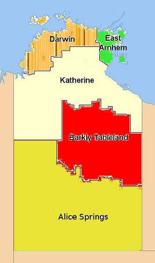
The Barkly Tableland is a rolling plain of grassland in Australia. It runs from the eastern part of the Northern Territory into western Queensland. It is one of the five regions in the Northern Territory and covers 283,648 square kilometres (109,517 sq mi), 21% of the Northern Territory. The Barkly Tableland runs parallel to the southern shore of the Gulf of Carpentaria, from about Mount Isa, Queensland to near Daly Waters.

<span class="mw-page-title-main">Urandangi</span> Town in Queensland, Australia

Urandangi is an outback town in the locality of Piturie in the Shire of Boulia, Queensland, Australia.

<span class="mw-page-title-main">Lawn Hill, Queensland</span> Suburb of Shire of Burke, Queensland, Australia

Lawn Hill is an outback locality split between the Shire of Burke and the City of Mount Isa in Queensland, Australia. The locality is on the Queensland border with the Northern Territory. In the 2016 census Lawn Hill had a population of 19 people.

<span class="mw-page-title-main">Community Hall, Camooweal</span> Historic site in Queensland, Australia

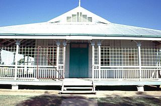
Community Hall is a heritage-listed former town hall at Barkly Highway, Camooweal, City of Mount Isa, Queensland, Australia. It was designed by Rooney Brothers and built from 1922 to 1923 by Hogarth & Hammond. It is also known as Barkly Tablelands Shire Hall. It was added to the Queensland Heritage Register on 21 October 1992.

Parkside is a suburb of Mount Isa in the City of Mount Isa, Queensland, Australia. In the 2016 census, Parkside had a population of 1,532 people.

<span class="mw-page-title-main">Waverley, Queensland</span> Suburb of Shire of Boulia, Queensland, Australia

Waverley is an outback locality in the Shire of Boulia, Queensland, Australia. In the 2021 census, Waverley had a population of 6 people.

<span class="mw-page-title-main">Gunpowder, Queensland</span> Town in Queensland, Australia

Gunpowder is an outback town and locality in the City of Mount Isa, Queensland, Australia. In the 2016 census, Gunpowder had a population of 43 people.

<span class="mw-page-title-main">Amaroo, Queensland</span> Suburb of Shire of Boulia, Queensland, Australia

Amaroo is an outback locality split between the Shire of Boulia and the Shire of Diamantina, both in Central Western Queensland, Australia. In the 2016 census, Amaroo had a population of 22 people.

Carrandotta is a locality in the Shire of Boulia, Queensland, Australia. In the 2016 census, Carrandotta had a population of 0 people.

<span class="mw-page-title-main">Georgina, Queensland</span> Suburb of Shire of Boulia, Queensland, Australia

Georgina is an outback locality in the Shire of Boulia, Queensland, Australia. In the 2021 census, Georgina had a population of 21 people.

Piturie is an outback locality in the Shire of Boulia, Queensland, Australia. In the 2016 census, Piturie had a population of 59 people. The town of Urandangi is within the locality.

Humboldt is a rural locality in the Central Highlands Region, Queensland, Australia. In the 2016 census, Humboldt had a population of 13 people.

Mantuan Downs is a rural locality in the Central Highlands Region, Queensland, Australia. In the 2016 census Mantuan Downs had a population of 31 people.

Laglan is a rural locality in the Isaac Region, Queensland, Australia. In the 2016 census Laglan had a population of 3 people, but its boundaries have subsequently changed.

Mount Howe is a rural locality in the Maranoa Region, Queensland, Australia. In the 2016 census Mount Howe had a population of 3 people.

<span class="mw-page-title-main">Taldora, Queensland</span> Suburb of Shire of Mckinlay, Queensland, Australia

Taldora is an outback locality in the Shire of Mckinlay, Queensland, Australia. In the 2016 census Taldora had a population of 37 people.

Menzies is a suburb in the City of Mount Isa, Queensland, Australia. In the 2021 census, Menzies had a population of 824 people.

References

  1. 1 2 3 Australian Bureau of Statistics (27 June 2017). "Barkly (SSC)". 2016 Census QuickStats. Retrieved 20 October 2018. OOjs UI icon edit-ltr-progressive.svg
  2. 1 2 "Barkly – locality in City of Mount Isa (entry 42311)". Queensland Place Names. Queensland Government . Retrieved 19 December 2020.
  3. 1 2 3 4 5 6 7 8 "Queensland Globe". State of Queensland . Retrieved 19 December 2020.
  4. 1 2 "Barkly Tableland – plain in City of Mount Isa (entry 1654)". Queensland Place Names. Queensland Government . Retrieved 19 December 2020.
  5. 1 2 3 "Mountain ranges beaches and sea passages - Queensland". Queensland Open Data. Queensland Government. 12 November 2020. Archived from the original on 25 November 2020. Retrieved 25 November 2020.
  6. "Mountain peaks and capes - Queensland". Queensland Open Data. Queensland Government. 12 November 2020. Archived from the original on 25 November 2020. Retrieved 25 November 2020.
  7. "Mount Michael – mountain in Mount Isa City (entry 21764)". Queensland Place Names. Queensland Government . Retrieved 25 November 2020.
  8. "Homesteads - Queensland". Queensland Open Data. Queensland Government. 18 November 2020. Archived from the original on 24 November 2020. Retrieved 24 November 2020.
  9. 1 2 3 "Heliports and landing grounds - Queensland". Queensland Open Data. Queensland Government. 22 October 2020. Archived from the original on 16 November 2020. Retrieved 3 November 2020.
  10. "Spinifex State College Mount Isa Residential Campus" (PDF). Spinifex State College . Archived (PDF) from the original on 24 March 2020. Retrieved 20 December 2020.