
Mount Isa is a city in the Gulf Country region of Queensland, Australia. It came into existence because of the vast mineral deposits found in the area. Mount Isa Mines (MIM) is one of the most productive single mines in world history, based on combined production of lead, silver, copper and zinc.

Spinifex State College is a public, co-educational, day and boarding school located in Mount Isa, Queensland. It first opened in 2003.

Duchess is a rural town and locality in the Shire of Cloncurry, Queensland, Australia. In the 2021 census, the locality of Duchess had a population of 53 people.
Pioneer is a suburb of the town of Mount Isa in the City of Mount Isa, Queensland, Australia. In the 2021 census, Pioneer had a population of 2,346 people.

Townview is a suburb of the town of Mount Isa in the City of Mount Isa, Queensland, Australia. In the 2021 census, Townview had a population of 2,067 people.
Happy Valley is a suburb of the town of Mount Isa in the City of Mount Isa, Queensland, Australia. In the 2021 census, Happy Valley had a population of 733 people.
Healy is a suburb of Mount Isa in the City of Mount Isa, Queensland, Australia. In the 2021 census, Healy had a population of 1,824 people.
Sunset is a suburb of the town of Mount Isa in the City of Mount Isa, Queensland, Australia. In the 2021 census, Sunset had a population of 2,137 people.

Mount Isa City is the central suburb and central business district of the town of Mount Isa in the City of Mount Isa, Queensland, Australia. In the 2021 census, Mount Isa City had a population of 170 people.

The Gap is a suburb of the town of Mount Isa in the City of Mount Isa, Queensland, Australia. In the 2021 census, The Gap had a population of 817 people.
Menzies is a suburb of the town of Mount Isa in the City of Mount Isa, Queensland, Australia. In the 2021 census, Menzies had a population of 824 people.
Miles End is a suburb of the town of Mount Isa in the City of Mount Isa, Queensland, Australia. In the 2021 census, Miles End had a population of 280 people.
Soldiers Hill is a suburb of the town of Mount Isa in the City of Mount Isa, Queensland, Australia. In the 2021 census, Soldiers Hill had a population of 1,796 people.
Ryan is a mixed-use suburb of the town of Mount Isa in the City of Mount Isa, Queensland, Australia. In the 2021 census, Ryan had a population of 105 people.
Lanskey is a suburb of the town of Mount Isa in the City of Mount Isa, Queensland, Australia. In the 2021 census, Lanskey had a population of 101 people.
Fisher is a suburb of the town of Mount Isa in the City of Mount Isa, Queensland, Australia. In the 2021 census, Fisher had a population of 65 people.
Spreadborough is a suburb of the town of Mount Isa in the City of Mount Isa, Queensland, Australia. In the 2021 census, Spreadborough had a population of 55 people.
Mica Creek is a suburb of the town of Mount Isa in the City of Mount Isa, Queensland, Australia. In the 2021 census, Mica Creek had a population of 182 people.
Breakaway is a suburb of the town of Mount Isa in the City of Mount Isa, Queensland, Australia. In the 2021 census, Breakaway had a population of 187 people.

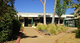
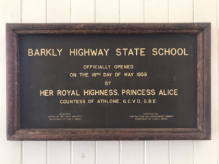
Spinifex State College Junior Campus is a heritage-listed state high school at 6–12 Fifth Avenue, Parkside, Mount Isa, City of Mount Isa, Queensland, Australia. It was designed by Department of Public Works (Queensland) and built in 1954. It is also known as Mount Isa State High School and Mount Isa Intermediate School. It was added to the Queensland Heritage Register on 23 August 2018.
