Wawona, California

Last updated

Wawona
Wawona Hotel in November 2004.jpeg
The Wawona Hotel
California Locator Map with US.PNG
Red pog.svg
Wawona
Usa edcp location map.svg
Red pog.svg
Wawona
Coordinates: 37°32′13″N119°39′23″W / 37.53694°N 119.65639°W / 37.53694; -119.65639
Country Flag of the United States (23px).png  United States
State Flag of California.svg California
County Mariposa
Area
[1]
  Total
1.076 sq mi (2.79 km2)
  Land1.076 sq mi (2.79 km2)
  Water0 sq mi (0 km2)  0%
Elevation
[2]
3,999 ft (1,219 m)
Population
 (2020) [3]
  Total
111
  Density103/sq mi (39.8/km2)
Time zone UTC-8 (Pacific (PST))
  Summer (DST) UTC-7 (PDT)
ZIP code
95389
Area code 209
GNIS feature IDs2583183 [2]

Wawona (formerly Big Tree Station, Clark's Station, Clarks Station, Wah-wo-nah, [2] and Clark's Ranch [4] ) is a census-designated place in Mariposa County, California, United States. [2] The population was 111 at the 2020 census. [3]

Contents

The community is located entirely within Yosemite National Park, as it preceded the founding of the park as a national recreation area. The number of inhabitants increases dramatically during peak tourist seasons, due to the large number of rental cabins in the town. It is located at 37°32′13″N119°39′23″W / 37.53694°N 119.65639°W / 37.53694; -119.65639 , [2] 20 miles (32 km) north of Oakhurst and 26 miles (42 km) south of the center of Yosemite Valley, at an elevation of 3,999 feet (1,219 m). [2]

The ZIP Code is 95389. The community is within area code 209.

History

It was known to the local Native American Miwok in their language as Pallachun ("a good place to stay"). [5] The origin of the word Wawona is not known. [6] [7] [8] A popular story claims Wawō'na was the Miwok word for "big tree", or for "hoot of the owl", a bird considered the sequoia trees' spiritual guardian. [9]

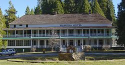
Galen Clark, who helped gain preservation legislation for Mariposa Grove and what became Yosemite National Park, occupied this area in 1855. He established a tourist rest and modest ranch in 1856. [4] Clark sold the property to the Washburn brothers in 1874, who built a larger hotel in 1876, adding to it later. Hotel keeper Jean Bruce Washburn named the resort property Wawona in 1883.

Wawona is the location of the historic Wawona Hotel, built by Washburn in 1876, with additional structures added into the early 20th century. A classic Victorian resort, it was designated a National Historic Landmark in 1987. [10]

The Clark's Station US Post Office opened in 1878. In 1883 its name was changed to Wawona. [4]

Geography

The view from Wawona Point, looking west-northwest over Wawona Meadow. Wawona Point View.jpg
The view from Wawona Point, looking west-northwest over Wawona Meadow.

The town is located in a large mid-elevation basin with Wawona Meadow as its centerpiece. [11] Situated in the southwest part of Yosemite National Park, it lies along the South Fork of the Merced River at an elevation of about 4,000 feet (1,200 m). The town is accessible via State Route 41, the main highway from Fresno to Yosemite Valley. Wawona is the closest town to Chilnualna Falls and the Mariposa Grove of Giant Sequoia. It also serves as the main gateway to the southern Yosemite wilderness, with several principal trailheads located here. [12]

According to the United States Census Bureau, the Wawona CDP covers an area of 1.08 square miles (2.8 km2), all of it land. [1]

Demographics

Historical population
CensusPop.Note
2010 169
2020 111−34.3%
U.S. Decennial Census [13]
1850–1870 [14] [15] 1880-1890 [16]
1900 [17] 1910 [18] 1920 [19]
1930 [20] 1940 [21] 1950 [22]
1960 [23] 1970 [24] 1980 [25]
1990 [26] 2000 [27] 2010 [28]

Wawona first appeared as a census-designated place in the 2010 United States census. [28]

The 2020 United States census reported that Wawona had a population of 111. The population density was 103.2 inhabitants per square mile (39.8/km2). The racial makeup was 99 (89.2%) White, 0 (0.0%) African American, 0 (0.0%) Native American, 0 (0.0%) Asian, 0 (0.0%) Pacific Islander, 7 (6.3%) from other races, and 5 (4.5%) from two or more races. Hispanic or Latino of any race were 7 persons (6.3%). [29]

There were 56 households, out of which 13 (23.2%) had children under the age of 18 living in them, 22 (39.3%) were married-couple households, 4 (7.1%) were cohabiting couple households, 14 (25.0%) had a female householder with no partner present, and 16 (28.6%) had a male householder with no partner present. 18 households (32.1%) were one person, and 9 (16.1%) were one person aged 65 or older. The average household size was 1.98. [29] There were 33 families (58.9% of all households). [30]

The age distribution was 20 people (18.0%) under the age of 18, 3 people (2.7%) aged 18 to 24, 28 people (25.2%) aged 25 to 44, 32 people (28.8%) aged 45 to 64, and 28 people (25.2%) who were 65 years of age or older. The median age was 49.5 years. There were 59 males and 52 females. [29]

There were 333 housing units at an average density of 309.5 units per square mile (119.5 units/km2), of which 56 (16.8%) were occupied. Of these, 31 (55.4%) were owner-occupied, and 25 (44.6%) were occupied by renters. [29]

Wawona is near the southern entrance to Yosemite. SW Yosemite map.png
Wawona is near the southern entrance to Yosemite.

Government

In the state legislature, Wawona is in the 4th senatorial district , represented by Republican Marie Alvarado-Gil, and in the 8th Assembly district , represented by Republican David Tangipa. [31]

In the United States House of Representatives, Wawona is in California's 5th congressional district , represented by Republican Tom McClintock. [32]

Attractions

References

  1. 1 2 "2021 U.S. Gazetteer Files: California". United States Census Bureau. Retrieved July 27, 2022.
  2. 1 2 3 4 5 6 U.S. Geological Survey Geographic Names Information System: Wawona, California
  3. 1 2 "P1. Race – Wawona CDP, California: 2020 DEC Redistricting Data (PL 94-171)". U.S. Census Bureau. Retrieved July 27, 2022.
  4. 1 2 3 Durham, David L. (1998). California's Geographic Names: A Gazetteer of Historic and Modern Names of the State. Clovis, California: Word Dancer Press. p. 844. ISBN   1-884995-14-4.
  5. Towns:Wawona, Yosemite/Madera County Film Commission, accessed December 8, 2009
  6. Farquhar, Francis P. "Place Names of the High Sierra". Yosemite Online. Retrieved March 9, 2016.
  7. Kroeber, Alfred J. (1916). "California Place Names of Indian Origin". American Archaeology and Ethnology. 12 (2): 66. Retrieved March 9, 2016.
  8. Clark, Galen (1904). Indians of the Yosemite Valley and Vicinity (1st ed.). Yosemite Valley, California. p. 109. Retrieved March 9, 2016.{{cite book}}: CS1 maint: location missing publisher (link)
  9. "The old-fashioned charm of Wawona - Sacramento Recreation and Places to Visit - Sacramento, Gold Country, Lake Tahoe, San Francisco | Sacramento Bee". www.sacbee.com. Archived from the original on December 2, 2008.
  10. "Wawona Hotel and Thomas Hill Studio". National Historic Landmark summary listing. National Park Service. September 25, 2007. Archived from the original on June 6, 2011. Retrieved December 8, 2009.
  11. "Yosemite Ranger Notes: Wawona Meadow". National Park Service. Retrieved July 11, 2024.
  12. "Wawona". National Park Service. Retrieved July 11, 2024.
  13. "Decennial Census by Decade". United States Census Bureau .
  14. "1870 Census of Population - Population of Civil Divisions less than Counties - California - Almeda County to Sutter County" (PDF). United States Census Bureau .
  15. "1870 Census of Population - Population of Civil Divisions less than Counties - California - Tehama County to Yuba County" (PDF). United States Census Bureau .
  16. "1890 Census of Population - Population of California by Minor Civil Divisions" (PDF). United States Census Bureau .
  17. "1900 Census of Population - Population of California by Counties and Minor Civil Divisions" (PDF). United States Census Bureau .
  18. "1910 Census of Population - Supplement for California" (PDF). United States Census Bureau .
  19. "1920 Census of Population - Number of Inhabitants - California" (PDF). United States Census Bureau .
  20. "1930 Census of Population - Number and Distribution of Inhabitants - California" (PDF). United States Census Bureau .
  21. "1940 Census of Population - Number of Inhabitants - California" (PDF). United States Census Bureau .
  22. "1950 Census of Population - Number of Inhabitants - California" (PDF). United States Census Bureau .
  23. "1960 Census of Population - General population Characteristics - California" (PDF). United States Census Bureau .
  24. "1970 Census of Population - Number of Inhabitants - California" (PDF). United States Census Bureau .
  25. "1980 Census of Population - Number of Inhabitants - California" (PDF). United States Census Bureau .
  26. "1990 Census of Population - Population and Housing Unit Counts - California" (PDF). United States Census Bureau .
  27. "2000 Census of Population - Population and Housing Unit Counts - California" (PDF). United States Census Bureau .
  28. 1 2 "2010 Census of Population - Population and Housing Unit Counts - California" (PDF). United States Census Bureau .
  29. 1 2 3 4 "Wawona CDP, California; DP1: Profile of General Population and Housing Characteristics - 2020 Census of Population and Housing". US Census Bureau. Retrieved July 14, 2025.
  30. "Wawona CDP, California; P16: Household Type - 2020 Census of Population and Housing". US Census Bureau. Retrieved July 14, 2025.
  31. "Final Maps | California Citizens Redistricting Commission" . Retrieved October 19, 2025.
  32. "California's 5th Congressional District - Representatives & District Map". Civic Impulse, LLC. Retrieved October 19, 2025.