Weirgor, Wisconsin

Last updated

Weirgor, Wisconsin
WIMap-doton-Weirgor.png
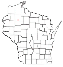
Location of Weirgor, Wisconsin
Coordinates: 45°40′45″N91°14′56″W / 45.67917°N 91.24889°W / 45.67917; -91.24889
Country Flag of the United States.svg  United States
State Flag of Wisconsin.svg  Wisconsin
County Sawyer
Area
  Total34.4 sq mi (89.1 km2)
  Land33.5 sq mi (86.8 km2)
  Water0.9 sq mi (2.3 km2)
Elevation
[1]
1,214 ft (370 m)
Population
 (2000)
  Total370
  Density11.0/sq mi (4.3/km2)
Time zone UTC-6 (Central (CST))
  Summer (DST) UTC-5 (CDT)
Area code(s) 715 & 534
FIPS code 55-85100 [2]
GNIS feature ID1584393 [1]

Weirgor is a town in Sawyer County, Wisconsin, United States. The population was 370 at the 2000 census.

Contents

Geography

According to the United States Census Bureau, the town has a total area of 34.4 square miles (89.1 km2), of which, 33.5 square miles (86.8 km2) of it is land and 0.9 square miles (2.3 km2) of it (2.59%) is water.

Demographics

As of the census [2] of 2000, there were 370 people, 157 households, and 113 families residing in the town. The population density was 11.0 people per square mile (4.3/km2). There were 243 housing units at an average density of 7.3 per square mile (2.8/km2). The racial makeup of the town was 94.32% White, 2.43% Native American, 1.62% Asian, 0.27% from other races, and 1.35% from two or more races. Hispanic or Latino of any race were 2.43% of the population.

There were 157 households, out of which 21.7% had children under the age of 18 living with them, 61.1% were married couples living together, 6.4% had a female householder with no husband present, and 28.0% were non-families. 24.8% of all households were made up of individuals, and 10.2% had someone living alone who was 65 years of age or older. The average household size was 2.36 and the average family size was 2.79.

In the town, the population was spread out, with 19.7% under the age of 18, 5.4% from 18 to 24, 25.4% from 25 to 44, 29.5% from 45 to 64, and 20.0% who were 65 years of age or older. The median age was 44 years. For every 100 females, there were 110.2 males. For every 100 females age 18 and over, there were 116.8 males.

The median income for a household in the town was $31,875, and the median income for a family was $33,750. Males had a median income of $25,156 versus $23,125 for females. The per capita income for the town was $15,691. About 7.2% of families and 8.5% of the population were below the poverty line, including 6.9% of those under age 18 and 11.9% of those age 65 or over.

Related Research Articles

<span class="mw-page-title-main">Malvern, Alabama</span> Town in Alabama, United States

Malvern is a town in Geneva County, Alabama, United States. It is part of the Dothan, Alabama Metropolitan Statistical Area. At the 2010 census the population was 1,448, up from 1,215 in 2000.

<span class="mw-page-title-main">Wailea-Makena, Hawaii</span> Former CDP in Hawaii, United States

Wailea-Makena was a census-designated place (CDP) in Maui County, Hawaiʻi, United States, during the 2000 census, at which time its population was 5,671. The area was split into two CDPs, Wailea and Makena, for the 2010 census.

<span class="mw-page-title-main">Irwin, Idaho</span> City in Idaho, United States

Irwin is a city in Bonneville County, Idaho, United States. It is part of the Idaho Falls, Idaho Metropolitan Statistical Area. The population was 219 at the 2010 census.

<span class="mw-page-title-main">Winchester, Kansas</span> City in Kansas, United States

Winchester is a city in Jefferson County, Kansas, United States. As of the 2020 census, the population of the city was 461.

<span class="mw-page-title-main">Collinston, Louisiana</span> Village in Louisiana, United States

Collinston is a village in Morehouse Parish, Louisiana, United States. The population was 274 at the 2020 census.

Princeton is a town in Washington County, Maine, United States. The town was named after Princeton, Massachusetts. The population was 745 at the 2020 census.

<span class="mw-page-title-main">Owendale, Michigan</span> Village in Michigan, United States

Owendale is a village in Huron County of the U.S. state of Michigan. The population was 241 at the 2010 census. The village is within Brookfield Township.

<span class="mw-page-title-main">Port Austin, Michigan</span> Village in Michigan, United States

Port Austin is a village in Huron County in the U.S. state of Michigan. The population was 664 at the 2010 census. The village is within Port Austin Township.

<span class="mw-page-title-main">Redings Mill, Missouri</span> Village in Missouri, United States

Redings Mill is a village in Newton County, Missouri, United States. The population was 151 at the 2010 census. It is part of the Joplin, Missouri Metropolitan Statistical Area.

<span class="mw-page-title-main">East Rochester, Pennsylvania</span> Borough in Pennsylvania, United States

East Rochester is a borough in central Beaver County, Pennsylvania, along the Ohio River. The population was 565 at the 2020 census. It is part of the Pittsburgh metropolitan area.

<span class="mw-page-title-main">Fernway, Pennsylvania</span> Former census-designated place in Pennsylvania, United States

Fernway is a neighborhood in Cranberry Township, Butler County, Pennsylvania, United States. It includes 458 homes on 183 acres and was the first planned housing subdivision in the Township, dating back to the 1950s. Fernway was formerly used as the name of a census-designated place (CDP), but the designation was removed as of TIGER 2013 after Cranberry Township officials pointed out that users of Internet mapping websites frequently misinterpreted the CDP as the name of its parent municipality.

<span class="mw-page-title-main">Chest Township, Cambria County, Pennsylvania</span> Township in Pennsylvania, United States

Chest Township is a township in Cambria County, Pennsylvania, United States. The population was 458 at the 2020 census. It is part of the Johnstown, Pennsylvania Metropolitan Statistical Area.

<span class="mw-page-title-main">Rutherford, Pennsylvania</span> Census-designated place in Pennsylvania, United States

Rutherford is a census-designated place (CDP) in Swatara Township, Dauphin County, Pennsylvania, United States. The area is also known as Rutherford Heights. The population was 4,303 at the 2010 census, an increase over the figure of 3,859 tabulated in 2000. It is part of the Harrisburg–Carlisle Metropolitan Statistical Area.

<span class="mw-page-title-main">Hartline, Washington</span> Town in Washington, United States

Hartline is a town in Grant County, Washington, United States. The population was 180 at the 2020 census. The high school for the Almira-Coulee/Hartline school district was located here, but moved to Coulee City, Washington in 2008. The name "Hartline" is an Americanized spelling of the German last name "Hartlein" and is an uncommon last name.

<span class="mw-page-title-main">Wyalusing, Wisconsin</span> Town in Wisconsin, United States

Wyalusing is a town in Grant County, Wisconsin, United States. The population was 370 at the 2000 census. The unincorporated communities of Brodtville and Wyalusing are located in the town. Pioneer Robert Glenn, Sr. is credited with naming the village "Wyalusing" after Wyalusing, Pennsylvania, because of a perceived resemblance.

<span class="mw-page-title-main">Exeter, Wisconsin</span> Town in Wisconsin, United States

Exeter is a town in Green County, Wisconsin, United States. The population was 1,261 at the 2000 census. The unincorporated communities of Dayton and Ross Crossing are located in the town.

<span class="mw-page-title-main">Cicero, Wisconsin</span> Town in Wisconsin, United States

Cicero is a town in Outagamie County, Wisconsin, United States. The population was 1,092 at the 2000 census.

Slim Lake is an unorganized territory in Saint Louis County, Minnesota, United States, located north of Ely and Morse Township. The population was 75 at the 2000 census.

<span class="mw-page-title-main">Halsey, Nebraska</span> Village in Blaine and Thomas counties in Nebraska, United States

Halsey is a village in Blaine and Thomas counties in Nebraska, United States. The population was 76 at the 2010 census.

Birchwood is a town in Washburn County, Wisconsin, United States. The population was 453 at the 2000 census. The Village of Birchwood is located within the town.

References

  1. 1 2 "US Board on Geographic Names". United States Geological Survey. October 25, 2007. Retrieved January 31, 2008.
  2. 1 2 "U.S. Census website". United States Census Bureau . Retrieved January 31, 2008.

45°41′24″N91°16′05″W / 45.69000°N 91.26806°W / 45.69000; -91.26806