West Mead Township, Pennsylvania

Last updated

West Mead Township,
Crawford County, Pennsylvania
PA 27 eb in West Mead Twp., June 2024.jpg
PA 27 eastbound in West Mead Township
Motto: 
"Where Good Things Are Happening"
Map of West Mead Township, Crawford County, Pennsylvania Highlighted.png
Location of West Mead Township in Crawford County
Map of Pennsylvania highlighting Crawford County.svg
Location of Crawford County in Pennsylvania
CountryUnited States
State Pennsylvania
County Crawford County
Area
[1]
  Total18.64 sq mi (48.27 km2)
  Land18.29 sq mi (47.37 km2)
  Water0.35 sq mi (0.90 km2)
Highest elevation
[2] (east of Fairgrounds)
1,570 ft (480 m)
Lowest elevation1,060 ft (320 m)
Population
 (2020) [3]
  Total5,043
  Estimate 
(2023) [3]
4,946
  Density281.08/sq mi (108.53/km2)
Time zone UTC-4 (EST)
  Summer (DST) UTC-5 (EDT)
ZIP code
16335 [4]
Area code 814
Website westmead.org

West Mead Township is a township in Crawford County, Pennsylvania, United States. The population was 5,043 at the 2020 census, [3] down from 5,249 at the 2010 census. [5]

Contents

History

In 1898, West Mead Township and East Mead Township were divided, from lands originally referred to as Mead Township. [6] The Bridge in West Mead Township was listed on the National Register of Historic Places in 1988. [7]

Geography

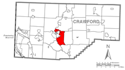
West Mead Township is located slightly southwest of the geographic center of Crawford County. It borders the city of Meadville to the north, east, and south. French Creek forms the western boundary of the township to the north and south of Meadville. Tamarack Lake is in the southeast.

According to the United States Census Bureau, the township has a total area of 18.8 square miles (48.6 km2), of which 18.3 square miles (47.4 km2) is land and 0.50 square miles (1.3 km2), or 2.65%, is water. [5]

Demographics

Historical population
CensusPop.Note
2000 5,227
2010 5,2490.4%
2020 5,043−3.9%
2023 (est.)4,946 [3] −1.9%
U.S. Decennial Census [8]

As of the census [9] of 2000, there were 5,227 people, 2,098 households, and 1,525 families residing in the township. The population density was 286.9 inhabitants per square mile (110.8/km2). There were 2,184 housing units at an average density of 119.9 per square mile (46.3/km2). The racial makeup of the township was 96.52% White, 2.07% African American, 0.23% Native American, 0.55% Asian, 0.08% from other races, and 0.55% from two or more races. Hispanic or Latino of any race were 0.50% of the population.

There were 2,098 households, out of which 31.6% had children under the age of 18 living with them, 59.5% were married couples living together, 9.4% had a female householder with no husband present, and 27.3% were non-families. 22.6% of all households were made up of individuals, and 11.1% had someone living alone who was 65 years of age or older. The average household size was 2.49 and the average family size was 2.92.

In the township the population was spread out, with 24.6% under the age of 18, 7.2% from 18 to 24, 26.6% from 25 to 44, 26.6% from 45 to 64, and 14.9% who were 65 years of age or older. The median age was 40 years. For every 100 females, there were 93.1 males. For every 100 females age 18 and over, there were 88.9 males.

The median income for a household in the township was $41,793, and the median income for a family was $47,156. Males had a median income of $38,144 versus $22,254 for females. The per capita income for the township was $19,241. About 6.8% of families and 8.2% of the population were below the poverty line, including 15.5% of those under age 18 and 3.2% of those age 65 or over.

Related Research Articles

<span class="mw-page-title-main">Blooming Valley, Pennsylvania</span> Borough in Pennsylvania, United States

Blooming Valley is a borough in Crawford County, Pennsylvania, United States. The population was 342 at the 2020 census, up from 337 at the 2010 census.

<span class="mw-page-title-main">Cochranton, Pennsylvania</span> Borough in Pennsylvania, United States

Cochranton is a borough in Crawford County, Pennsylvania, United States. The population was 1,124 at the 2020 census, down from 1,136 as of the 2010 census.

<span class="mw-page-title-main">Cussewago Township, Crawford County, Pennsylvania</span> Township in Pennsylvania, United States

Cussewago Township is a township in Crawford County, Pennsylvania, United States. The population was 1,430 at the 2020 census.

<span class="mw-page-title-main">East Mead Township, Crawford County, Pennsylvania</span> Township in Pennsylvania, United States

East Mead Township is a township in Crawford County, Pennsylvania, United States. The population was 1,321 at the 2020 census, down from 1,493 in the 2010 census.

<span class="mw-page-title-main">Fredericksburg, Crawford County, Pennsylvania</span> Census-designated place in Pennsylvania, United States

Fredericksburg is a census-designated place (CDP) in Crawford County, Pennsylvania, United States. The population was 733 at the 2010 census, down from 1,140 in 2000, when the CDP included the area that is now listed as Kerrtown.

<span class="mw-page-title-main">Oil Creek Township, Crawford County, Pennsylvania</span> Township of Titusville Pennsylvania in the United States

Oil Creek Township is a township in Crawford County, Pennsylvania, United States. The population was 1,703 at the 2020 census, a decrease from 1,877 at the 2010 census.

<span class="mw-page-title-main">Saegertown, Pennsylvania</span> Borough in Pennsylvania, United States

Saegertown is a borough in Crawford County, Pennsylvania. The population was 869 at the time of the 2020 census, down from 997 at the 2010 census. It was established in 1824.

<span class="mw-page-title-main">Summerhill Township, Crawford County, Pennsylvania</span> Township in Pennsylvania, United States

Summerhill Township is a township in Crawford County, Pennsylvania, United States. The population was 1,204 at the 2020 census, down from 1,236 at the 2010 census.

<span class="mw-page-title-main">Summit Township, Crawford County, Pennsylvania</span> Township in Pennsylvania, United States

Summit Township is a township in Crawford County, Pennsylvania, United States. The population was 1,901 at the 2020 census, down from 2,027 at the 2010 census.

<span class="mw-page-title-main">Union Township, Crawford County, Pennsylvania</span> Township in Pennsylvania, United States

Union Township is a township in Crawford County, Pennsylvania, United States. The population was 857 at the 2020 census, down from 1,010 at the 2010 census.

<span class="mw-page-title-main">Venango Township, Crawford County, Pennsylvania</span> Township in Pennsylvania, United States

Venango Township is a township in Crawford County, Pennsylvania, United States. The population was 941 at the 2020 census, down from 997 at the 2010 census.

<span class="mw-page-title-main">Vernon Township, Pennsylvania</span> Township in Pennsylvania, United States

Vernon Township is a township in Crawford County, Pennsylvania, United States. The population was 5,309 at the 2020 census, down from 5,630 at the 2010 census.

<span class="mw-page-title-main">Wayne Township, Crawford County, Pennsylvania</span> Township in Pennsylvania, United States

Wayne Township is a township in Crawford County, Pennsylvania, United States. The population was 1,409 at the 2020 census, down from 1,539 at the 2010 census.

<span class="mw-page-title-main">West Fallowfield Township, Crawford County, Pennsylvania</span> Township in Pennsylvania, United States

West Fallowfield Township is a township in Crawford County, Pennsylvania, United States. The population was 576 at the 2020 census, down from 605 at the 2010 census.

<span class="mw-page-title-main">West Shenango Township, Pennsylvania</span> Township in Pennsylvania, United States

West Shenango Township is a township in Crawford County, Pennsylvania, United States. The population was 433 at the 2020 census, down from 504 at the 2010 census.

<span class="mw-page-title-main">Woodcock, Pennsylvania</span> Borough in Pennsylvania, United States

Woodcock is a borough in Crawford County, Pennsylvania, United States. The population was 140 at the 2020 census, down from 157 at the 2010 census.

<span class="mw-page-title-main">Woodcock Township, Pennsylvania</span> Township in Pennsylvania, United States

Woodcock Township is a township in Crawford County, Pennsylvania, United States. The population was 2,756 at the 2020 census, down from 2,856 at the 2010 census.

<span class="mw-page-title-main">Barree Township, Pennsylvania</span> Township in Pennsylvania, United States

Barree Township is a township in Huntingdon County, Pennsylvania, United States. The population was 432 at the 2020 census.

<span class="mw-page-title-main">Branch Township, Pennsylvania</span> Township in Pennsylvania, United States

Branch Township is a township in Schuylkill County, Pennsylvania, United States. Formed in 1838 from part of Norwegian Township, it is named for the west branch of the Schuylkill River, which flows through it.

<span class="mw-page-title-main">Southwest Township, Warren County, Pennsylvania</span> Township in Pennsylvania, United States

Southwest Township is a township in Warren County, Pennsylvania, United States. The population was 426 at the 2020 census, down from 527 at the 2010 census. 561 at the 2000 census.

References

  1. "2016 U.S. Gazetteer Files". United States Census Bureau. Retrieved August 13, 2017.
  2. 1 2 "Cemetery Run Topo Map, Crawford County PA (Meadville Area)". TopoZone. Locality, LLC. Retrieved September 2, 2019.
  3. 1 2 3 4 Bureau, US Census. "City and Town Population Totals: 2020-2023". Census.gov. US Census Bureau. Retrieved June 6, 2024.
  4. "West Mead Township PA ZIP Code". zipdatamaps.com. 2023. Retrieved May 13, 2023.
  5. 1 2 "Geographic Identifiers: 2010 Census Summary File 1 (G001): West Mead township, Crawford County, Pennsylvania". U.S. Census Bureau, American Factfinder. Archived from the original on February 13, 2020. Retrieved June 15, 2015.
  6. What is the History of West Mead Township? West Mead Township website, accessed October 11, 2023.
  7. "National Register Information System". National Register of Historic Places . National Park Service. July 9, 2010.
  8. "Census of Population and Housing". Census.gov. Retrieved June 4, 2016.
  9. "U.S. Census website". United States Census Bureau . Retrieved January 31, 2008.

41°40′00″N80°08′59″W / 41.66667°N 80.14972°W / 41.66667; -80.14972