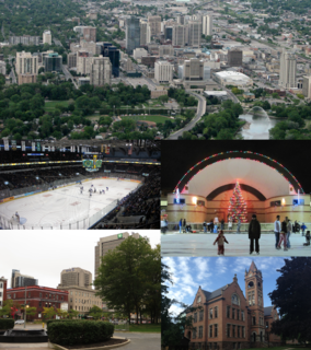
London is a city in southwestern Ontario, Canada, along the Quebec City–Windsor Corridor. The city had a population of 383,822 according to the 2016 Canadian census. London is at the confluence of the Thames River, approximately 200 km (120 mi) from both Toronto and Detroit; and about 230 km (140 mi) from Buffalo, New York. The city of London is politically separate from Middlesex County, though it remains the county seat.

Middlesex County is a primarily rural county in Southwestern Ontario, Canada covering 3,317.27 square kilometres. Landlocked, the county is bordered by Huron and Perth counties on the north, Oxford County on the east, Elgin County on the south, and Chatham-Kent and Lambton County on the west.

Innisfil is a town in Ontario, Canada, located on the western shore of Lake Simcoe in Simcoe County, immediately south of Barrie and 80 kilometres (50 mi) north of Toronto. It has historically been a rural area, but due to being geographically sandwiched in between the high-growth areas of Barrie area and York Region has meant greater residential development in Innisfil.

Byron is a neighbourhood in the City of London, Ontario, Canada. It is adjacent to the Thames River in the south-west of London. Almost all of its residents live in low-density, single detached dwellings. As of 2011, the area is home to 15,525 residents. The neighbourhood is considered a middle-income area, with an average family income of $64,525 an average dwelling value of $312,896 and a home ownership rate of 93%.
Highbury Avenue is an arterial road located in the Canadian province of Ontario. In addition to serving as a primary north–south thoroughfare in eastern London – through which part of it is a limited-access freeway – the road also provides access to Highway 401 and continues south to St. Thomas. The southern terminus of Highbury Avenue is an intersection with South Edgeware Road, just north of Highway 3 and the eastern end of the St. Thomas Expressway. From there, it travels 45.6 kilometres (28.3 mi) north to Highway 7, east of Elginfield. Outside of London and St. Thomas, the road also passes through the communities of Ballymote and Bryanston. It is designated as Elgin County Road 30 within Central Elgin, and as Middlesex County Road 23 within Middlesex Centre, the two rural municipalities through which the route passes.
Bruce Smith is a former politician in Ontario, Canada. He served as a Progressive Conservative member of the Legislative Assembly of Ontario from 1995 to 1999.
Middlesex East was a former federal electoral district in Ontario, Canada, represented in the House of Commons of Canada from 1867 to 1968. It was created by the British North America Act of 1867, which divided the County of Middlesex into three ridings: Middlesex North, Middlesex West and Middlesex East.
Middlesex was a federal electoral district represented in the House of Commons of Canada from 1968 to 1979. It was located in the province of Ontario. This riding was created in 1966 from parts of Lambton West, Lambton—Kent, Middlesex West and Middlesex East ridings.
London—Middlesex was a federal electoral district that was represented in the House of Commons of Canada from 1979 to 1997. It was located in the province of Ontario.

Lambeth is a neighbourhood in the City of London, Ontario, Canada. It is immediately north of Highway 402, and east of Colonel Talbot Road. Almost all of its residents live in low-density, single detached dwellings. As of 2011, the area is home to 4,410 residents. The neighbourhood is considered a middle to upper-income area, with an average family income of $129,685 an average dwelling value of $340,707 and a home ownership rate of 93%.
Wonderland Road is a major north-south arterial road in London, Ontario, designated as Ontario Highway 4 between Highway 401 and Sunningdale Road. Outside of the City limits, the road extends north into Middlesex Centre as Middlesex County Road 56 and south into Southwold. It is one of the busiest roads in London, carrying over 43,000 vehicles per day between Springbank Drive and Riverside Drive as of 2013.

Tempo is an unincorporated place in the city of London in Southwestern Ontario, Canada. It is located just south of the community of Lambeth at interchange 177 of Ontario Highway 401 with the former Ontario Highway 4.
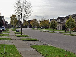
Uplands is a neighbourhood in the City of London, Ontario, Canada. The neighbourhood is located in the northern part of the city. Almost all of its residents live in low-density, single detached dwellings. As of 2011, the area is home to 7,835 residents. The neighbourhood is considered a middle to upper-income area, with an average family income of $128,806 an average dwelling value of $371,210 and a home ownership rate of 85%.

Fanshawe Pioneer Village is an open-air museum established in 1959 and located in the Fanshawe Conservation Area in London, Ontario. The village uses historical re-enactments to communicate the history of rural communities in the former townships of Westminster, London, North Dorchester, Delaware, West Nissouri and Lobo in Middlesex County from 1820 to 1920 and the founding and development of the City of London up to 1840.
King's Highway 73, commonly referred to as Highway 73, was a provincially maintained highway in the Canadian province of Ontario. The route began in Port Bruce and progressed north through Aylmer, encountering Highway 401 immediately before terminating east of Dorchester. The route was established in mid-1937, remaining unchanged for nearly six decades before being transferred to Elgin County and Middlesex County in 1997 and 1998. Today the route is known as Elgin County Road 73 and Middlesex County Road 73.
Huron Heights is a neighbourhood in the City of London, Ontario, Canada. Located in the northeast part of the city, development began around 1960 and continued to the late 1960s in four distinct phases, and included three public elementary schools, and provided students to one Catholic elementary in the area and one public secondary school just northwest of the development. A large commercial plaza with anchor grocery and department stores was developed at the west edge, and a neighbourhood plaza was developed in the central part. A city arena was built and later supplemented with a public swimming pool.
King's Highway 74, commonly referred to as Highway 74, was a provincially maintained highway in the Canadian province of Ontario that travelled north from Highway 3 at New Sarum to Middlesex County Road 29 on the outskirts of London. The 22.4-kilometre-long (13.9 mi) was assumed by the province in September 1937. Aside from paving and the construction of an interchange with Highway 401, it remained generally unchanged for the next six decades until it was decommissioned in 1997 and transferred to Elgin County and Middlesex County. The road has since been redesignated as Elgin County Road 74 and Middlsex County Road 74.
King's Highway 76, commonly referred to as Highway 76, was a provincially maintained highway in the Canadian province of Ontario. The route began at Highway 3 in Eagle and progressed north through the community of West Lorne, encountering Highway 401 immediately before terminating southwest of Glencoe at Longwoods Road. Today the route it followed is known as Elgin County Road 76 and Middlesex County Road 76.
