
Peter Peak is a 12,490-foot-elevation (3,810-meter) mountain summit located west of the crest of the Sierra Nevada mountain range, in Fresno County of central California, United States. It is situated in northern Kings Canyon National Park, 2 miles (3.2 km) southwest of The Hermit, and 0.6 miles (0.97 km) northwest of Mount McGee, the nearest higher neighbor. Topographic relief is significant as the west aspect rises 2,900 feet above Goddard Canyon in 1.5 mile. The John Muir Trail passes to the east, providing an approach. This geographical feature was named by the Sierra Club in 1938 in memory of one of their own, Peter Grubb (1919–1937), who made the first ascent of this peak in 1936. Peter died at Capri, age 18, while traveling on a bicycle tour of Italy. This mountain's name has been officially adopted by the United States Board on Geographic Names.

Emerald Peak is a 12,546-foot-elevation (3,824-meter) mountain summit located west of the crest of the Sierra Nevada mountain range, in Fresno County of central California, United States. It is situated in northern Kings Canyon National Park, southwest of Evolution Valley, and 2.3 miles (3.7 km) northwest of Mount McGee, the nearest higher neighbor. Other nearby peaks include The Hermit, 2.5 miles (4.0 km) to the east, and Peter Peak, 1.6 miles (2.6 km) to the southeast. Topographic relief is significant as the west aspect rises over 3,500 feet above Goddard Canyon in 1.5 mile. The John Muir Trail passes to the northeast, providing an approach.

Mount McGee is a 12,944-foot-elevation (3,945-meter) mountain summit located west of the crest of the Sierra Nevada mountain range, in Fresno County of central California, United States. It is situated in northern Kings Canyon National Park, 0.6 miles (0.97 km) southeast of Peter Peak, 2 miles (3.2 km) southwest of The Hermit, and 2.6 miles (4.2 km) north-northwest of Mount Goddard, the nearest higher neighbor. Topographic relief is significant as the west aspect rises 3,100 feet above Goddard Canyon in two miles. This geographical feature was named for William John McGee (1853–1912), well-known American geologist and anthropologist. This mountain's name has been officially adopted by the United States Board on Geographic Names. The first ascent of the summit was made in July 1923 by Roger N. Burnham, Robert E. Brownlee, Ralph H. Brandt, and Leonard Keeler.
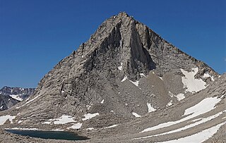
Merriam Peak is a 13,103-foot-elevation (3,994-meter) mountain summit located in Fresno County in the Sierra Nevada mountain range in northern California, United States. It is situated south of the Royce Lakes and north of French Canyon, in the John Muir Wilderness, on land managed by Sierra National Forest. It is set 0.7 miles (1.1 km) south-southeast of Royce Peak, the nearest higher neighbor. Merriam Peak is the 129th highest summit in California. Topographic relief is significant as it rises approximately 3,000 feet above French Canyon in one mile. This mountain was named in 1929 by the California State Geographic Board, and officially adopted in 1930 by the U.S. Board on Geographic Names to honor Dr. Clinton Hart Merriam (1855–1942), an American zoologist and naturalist, who served on the U.S. Board on Geographic Names from 1914 through 1925.

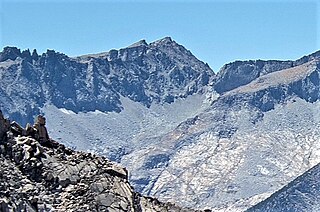
Gemini is a 12,880-foot-elevation (3,926-meter) twin-peaked mountain summit located west of the crest of the Sierra Nevada mountain range in Fresno County of northern California, United States. It is situated in the John Muir Wilderness, on land managed by Sierra National Forest. It is set 3.0 miles (4.8 km) west-southwest of Merriam Peak, 2.6 miles (4.2 km) northeast of Mount Senger, and 1.2 miles (1.9 km) southeast of Seven Gables, the nearest higher neighbor. Topographic relief is significant as it rises over 3,500 feet above Piute Canyon in approximately three miles. Gemini ranks as the 176th-highest summit in California.

Mount Powell is a 13,364-foot-elevation mountain summit located on the crest of the Sierra Nevada mountain range in California, United States. It is situated on the shared boundary of Kings Canyon National Park with John Muir Wilderness, and along the common border of Fresno County with Inyo County. It is also 19 miles (31 km) west of the community of Big Pine, and 1.17 miles (1.88 km) west of Mount Thompson, which is the nearest higher neighbor. Mount Powell ranks as the 81st highest peak in California, and the 10th highest of the Evolution Region of the Sierra Nevada. The west summit is unofficially known as "Point John." Two other peaks on the mountain are informally called "Point Wesley" (13,356 ft) in the middle, and "Point Powell" (13,360+ ft) one-half mile to the east.

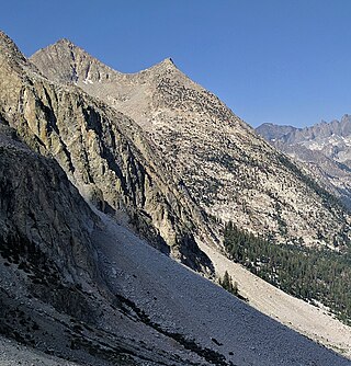
State Peak is a remote 12,620-foot-elevation (3,850-meter) mountain summit located in Kings Canyon National Park, in Fresno County of northern California, United States. It is situated on Cirque Crest which is west of the crest of the Sierra Nevada mountain range, 3.03 miles (4.88 km) west of Arrow Peak, and 2.13 miles (3.43 km) southwest of Marion Peak, the nearest higher neighbor. Topographic relief is significant as the west aspect rises 2,100 feet above State Lakes in 1.5 mile, and the southeast aspect rises 4,000 feet above South Fork Kings River in 1.5 mile.
Mount Lamarck is a 13,417-foot-elevation (4,090-meter) mountain summit located on the crest of the Sierra Nevada mountain range in northern California, United States. It is situated on the shared boundary of Kings Canyon National Park with John Muir Wilderness, and along the common border of Fresno County with Inyo County. It is 20 miles (32 km) southwest of the community of Bishop, and 1.9 miles (3.1 km) north of Mount Darwin. Subsidiary peak Mount Lamarck North (13,464 feet ranks as the 67th highest summit in California, and the sixth highest in the Evolution Region. Topographic relief is significant as the east aspect rises 4,290 feet above Lake Sabrina in three miles, and the west aspect rises 3,600 feet above Evolution Valley in three miles.

Highland Peak is a prominent 10,936-foot-elevation (3,333-meter) mountain summit located in the Sierra Nevada mountain range, in Alpine County of northern California, United States. It is situated 3.5 miles east of Ebbetts Pass in the Carson-Iceberg Wilderness, on land managed by Humboldt–Toiyabe National Forest. Although it ranks as the 680th-highest summit in California, it ranks 36th-highest of those with at least 500 meters of topographic prominence. Also, there is no higher peak than Highland Peak to the north within the Sierra Nevada. Highland Peak has a subsidiary South Peak, with one-half mile separation between summits. The Pacific Crest Trail traverses the western foot of this mountain, providing an approach option. Precipitation runoff from this mountain drains into tributaries of the East Fork Carson River.. Topographic relief is significant as the summit rises over 2,900 feet above Noble Canyon in 1.6 mile (2.6 km).

Vandever Mountain is an 11,947-foot-elevation (3,641-meter) mountain summit located in the Sierra Nevada mountain range, in Tulare County of northern California. It is situated on the shared boundary of Sequoia National Park with Sequoia National Forest, four miles south of Mineral King, and 1.78 miles (2.86 km) west of Florence Peak, the nearest higher neighbor. Vandever Mountain ranks as the 439th highest summit in California. Topographic relief is significant as the south aspect rises 2,000 feet above White Chief Canyon in one mile. The summit can be reached via class 2 hiking from Farewell Gap or White Chief Canyon.

Goat Mountain is a 12,207-foot-elevation (3,721-meter) mountain summit located in Kings Canyon National Park, in Fresno County of northern California, United States. It is situated on Monarch Divide which is west of the crest of the Sierra Nevada mountain range. Topographic relief is significant as the southeast aspect rises 5,600 feet above Paradise Valley in 2.5 miles. This feature was so named because mountain sheep, erroneously called goats, were once seen on the slopes. The name was already in use when the first ascent of the summit was made in 1896 by Joseph Nisbet LeConte and party. This mountain's name has been officially adopted by the United States Board on Geographic Names.

The Sphinx is a 9,143-foot-elevation (2,787-meter) double summit granitic pillar located west of the crest of the Sierra Nevada mountain range, in Kings Canyon National Park, in Fresno County of northern California. This landmark is situated at the northern end of the Great Western Divide, two miles southeast of Kanawyers, five miles northwest of North Guard, and immediately south of the confluence of Bubbs Creek and South Fork Kings River. Topographic relief is significant as the north aspect rises 4,000 feet above the canyon in one mile. This geographical feature was named in 1891 by John Muir. This feature's name has been officially adopted by the United States Board on Geographic Names. The Sphinx formation is the further north and slightly lower of the two peaks, and was the first rock climb done in the Kings Canyon region. The first ascent of the summit was made July 26, 1940, by Art Argiewicz and Bob Jacobs. The North Buttress was first climbed October 18, 1970, by Fred Beckey, Greg Donaldson, and Walt Vennum.

Mount Jordan is a remote 13,343-foot-elevation (4,067-meter) mountain summit located on the Kings–Kern Divide of the Sierra Nevada mountain range, in Tulare County of northern California. It is situated on the shared boundary of Kings Canyon National Park with Sequoia National Park, 3.1 miles (5.0 km) southwest of Mount Stanford, and one mile west of Mount Genevra, which is the nearest neighbor. Topographic relief is significant as the north aspect rises 3,313 feet above Lake Reflection in 1.3 mile. Mount Jordan ranks as the 84th highest summit in California, and the fifth-highest peak on the Kings–Kern Divide.

Grand Sentinel is an 8,518-foot-elevation (2,596-meter) pillar located west of the crest of the Sierra Nevada mountain range, in Kings Canyon National Park, in Fresno County of northern California. This landmark is situated at the northern end of the Great Western Divide, two miles west-northwest of The Sphinx, and immediately south of Kanawyers and Zumwalt Meadow. Topographic relief is significant as the north aspect rises nearly 3,500 feet above the canyon floor in one-half mile. This feature's name has been officially adopted by the United States Board on Geographic Names.
South Guard is a remote 13,232-foot-elevation (4,033-meter) mountain summit located near the northern end of the Great Western Divide of the Sierra Nevada mountain range, in Tulare County of northern California. It is situated in Kings Canyon National Park, 1.63 miles (2.62 km) south of North Guard, and one mile south of Mount Brewer, which is the nearest higher neighbor. Topographic relief is significant as the west aspect rises 4,600 feet above Cloud Canyon in 3.5 miles, and the east aspect rises 3,200 feet above Lake Reflection in two miles. South Guard ranks as the 103rd highest summit in California, and the third-highest point of the northern Great Western Divide.
Mount Shakspere is a 12,174-foot-elevation summit located in Fresno County, California, United States.

Observation Peak is a 12,362-foot-elevation summit located in Fresno County, California, United States.

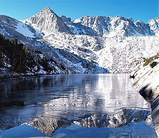
Pilot Knob is a 12,245-foot-elevation (3,732 meter) mountain summit located in Fresno County in the Sierra Nevada mountain range in northern California, United States. It is situated at the intersection of Piute Canyon and French Canyon, in the John Muir Wilderness, on land managed by Sierra National Forest. It is set 2.5 miles (4.0 km) south of Merriam Peak and three miles north of the Matthes Glaciers. Pilot Knob is the 360th-highest peak in California, and topographic relief is significant as the west aspect rises 2,800 feet above Hutchinson Meadow in approximately one mile. This mountain was likely named by the USGS during the 1907–09 survey for the Mt. Goddard Quadrangle, and the toponym has been officially adopted by the U.S. Board on Geographic Names.

Kennedy Mountain is an 11,433-foot-elevation (3,485 meter) summit located in Fresno County, California, United States. It is situated in Kings Canyon National Park, on Monarch Divide which is west of the crest of the Sierra Nevada mountain range. Mount Harrington is four miles to the west along the divide, and Kennedy Pass less than a mile east. Kennedy Mountain ranks as the 569th-highest summit in California, and topographic relief is significant as the northeast aspect rises 2,000 feet above Kennedy Canyon in approximately one mile. The first ascent of the summit was made by a 1903 USGS survey party, and likely named for one of the agency's employees. Inclusion on the Sierra Peaks Section peakbagging list generates climbing interest. This landform's toponym has been officially adopted by the U.S. Board on Geographic Names.

Kennedy Peak is a 10,718-foot-elevation (3,267 meter) mountain summit located in Tuolumne County, California, United States.


