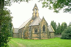
Whitley | |
---|---|
All Saints Whitley | |
Location within North Yorkshire | |
Population | 1,021 (2011 census) [1] |
OS grid reference | SE561212 |
Unitary authority | |
Ceremonial county | |
Region | |
Country | England |
Sovereign state | United Kingdom |
Post town | GOOLE |
Postcode district | DN14 |
Dialling code | 01977 |
Police | North Yorkshire |
Fire | North Yorkshire |
Ambulance | Yorkshire |
Whitley is a village in North Yorkshire, England, close to the Aire and Calder Navigation and the M62 motorway. The population of the village at the 2001 census was recorded as being 574, [2] which had risen to 1,021 by the time of the 2011 census. [1] In 2015, North Yorkshire County Council estimated the population to have risen again to 1,110. [3] It was historically part of the West Riding of Yorkshire until 1974. [4] From 1974 to April 2023 it was in the Selby District of North Yorkshire.
The village is recorded in the Domesday Book as Witelai, [5] with the name deriving from the Old English words of hwīt and lēah, meaning White wood clearing. [6] The village is located on the A19 road, south of its intersection with the M62 Motorway at Junction 34, [7] 6 miles (9.7 km) west of Snaith and 7 miles (11 km) north east of Pontefract. [8] [9] The village is served by Whitley Bridge railway station to the north, but only has one train a day eastwards and only two westwards. [10] [11]
The village has a primary school and a church, the Chapel of All Saints, which was built between 1858 and 1861. [12] [13] A Knights Templar manor is believed to have existed south west of the village between 1248 and 1312. Unlike other Templar possessions which were taken over, when the order was dissolved, Whitley Preceptory was left to ruin. [14]
An electoral ward in the same name exists. This ward stretches south west to Kirk Smeaton with a total population taken at the 2011 census of 4,391. [15]
Ledsham is a village and civil parish 4 miles (6 km) north of Castleford and 11 miles (18 km) east of Leeds in the county of West Yorkshire, England. The village is in the City of Leeds metropolitan borough and near to the A1(M) motorway. It had a population of 162 at the 2001 Census, increasing to 181 at the 2011 Census.
Eggborough is a village and civil parish in North Yorkshire, England, close to the county borders with South Yorkshire, West Yorkshire and the East Riding.
Kippax is a town and civil parish in the City of Leeds, West Yorkshire, England. It is situated to the east of the city, near to Garforth and Great Preston.
Beal is a village and civil parish in North Yorkshire, England. It is situated on the River Aire, 3.5 miles (6 km) north-east of Knottingley, 8 miles (13 km) south-west of Selby, and 21 miles (34 km) south of York. The parish includes the village of Kellingley, and borders the City of Wakefield in West Yorkshire. At the 2001 census it had a population of 720, increasing to 738 at the 2011 census.
Bishop Monkton is a village and civil parish in the former Harrogate district of North Yorkshire, England, about five miles south of Ripon. According to the 2001 census it had a population of 775, increasing slightly to 778 at the 2011 Census. In 2015, North Yorkshire County Council estimated the population to be 760.
Brotherton is a village and civil parish in the Selby District of North Yorkshire, England. The village is on a border with the City of Wakefield and West Yorkshire.
Camblesforth is a village and civil parish in the former Selby District of North Yorkshire, England. According to the 2001 Census the civil parish had a population of 1,526, increasing to 1,568 at the 2011 Census. The village is 5 miles (8 km) south of Selby and 7 miles (11 km) west of Goole. It was historically part of the West Riding of Yorkshire until 1974.
Thorganby is a small village and civil parish in North Yorkshire, England. It was historically part of the East Riding of Yorkshire until 1974, but from 1974 to 2023 was in the Selby District of the shire county of North Yorkshire. In 2023 the district was abolished and North Yorkshire became a unitary authority.
South Milford is a village and civil parish in the county of North Yorkshire, England. The civil parish includes the hamlet of Lumby, located south-west of the main village.
North Stainley is a village in the Harrogate district of North Yorkshire, England 4 miles (6.4 km) north of Ripon. Historically part of the West Riding of Yorkshire, it is the closest settlement to the theme park Lightwater Valley which is 0.62 miles (1 km) to the south.
Kellington is a small village and civil parish in the Selby District of North Yorkshire, England, on the banks of the River Aire. Situated almost equidistant between the towns of Pontefract and Selby, the village dates back to at least the 11th century when it was listed in the Domesday Book. The semi-rural community grew in size with the advent of local mining as housing was built to accommodate the workers of nearby Kellingley Colliery.
Kirk Deighton is a village and civil parish in the Harrogate district of North Yorkshire, England. It is situated north-west of Wetherby and near the A1(M) motorway. The village was in the West Riding of Yorkshire, and Wetherby Rural District, until 1974, and is now 0.5 mile north of the border between West Yorkshire and North Yorkshire.
Pollington is a village and civil parish in the East Riding of Yorkshire, England. It is situated approximately 2 miles (3.2 km) south-west of the town of Snaith and 1 mile (1.6 km) south of the M62 motorway. It lies on the north bank of the Aire and Calder Navigation.
Gowdall is a village and civil parish in the East Riding of Yorkshire, England. It is situated approximately 1 mile (1.6 km) west of the town of Snaith, 1 mile to the north of the M62 motorway and the A645 road, and just south of the River Aire.
Stillingfleet is a village and civil parish in North Yorkshire, England. It was in the historic East Riding of Yorkshire, but since 1974 has come under North Yorkshire. It is about 6 miles (10 km) south of York and nearby settlements include Acaster Selby, Naburn and Appleton Roebuck.
Ulleskelf is a village and civil parish in the Selby District of North Yorkshire, England, four miles from Tadcaster on the River Wharfe.
Monk Fryston is a small village and civil parish in the former Selby district of North Yorkshire, England.
Hambleton is a small village and civil parish near to Selby in North Yorkshire, England. It is a ward of the Selby District and should not be confused with the Hambleton District, another district of North Yorkshire.
Walden Stubbs is a small, rural village and civil parish in North Yorkshire, England. At the 2011 Census, the population was less than 100, so the details are included in the civil parish of Womersley. Situated close to the border with South Yorkshire, and north of Doncaster, it is 7 miles (11 km) south east of Pontefract, and lies close to the River Went, which rises at Featherstone.
East Hardwick is a village and civil parish in the City of Wakefield in West Yorkshire, England. It has a population of 191, reducing to 173 at the 2011 Census. Until 1974 it was part of Osgoldcross Rural District.