Williston Basin

Last updated
North america with-Williston.jpg
WillistonBasinLocation.jpg
Location of Williston Basin
Williston Basin tectonic map.jpg
Williston Basin structure map.jpg
Tectonic and structure geologic maps

The Williston Basin is a large intracratonic sedimentary basin in eastern Montana, western North Dakota, South Dakota, southern Saskatchewan, and south-western Manitoba that is known for its rich deposits of petroleum and potash. The basin is a geologic structural basin but not a topographic depression; it is transected by the Missouri River. The oval-shaped depression extends approximately 475 miles (764 km) north-south and 300 miles (480 km) east-west.

Contents

The Williston Basin lies above an ancient Precambrian geologic basement feature, the Trans-Hudson Orogenic Belt that developed in this area about 1.8-1.9 billion years ago, and that created a weak zone that later led to sagging to produce the basin. [1] The Precambrian basement rocks in the center of the basin beneath the city of Williston, North Dakota lie about 16,000 feet (4,900 m) below the surface.

WillistonStratCol.jpg
Williston Basin stratigraphic column.jpg
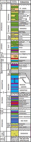
Stratigraphic column showing 12 hydrocarbon source beds and 15 reservoir rocks in the Williston Basin

Deposition of sediments began in the Williston area during Cambrian time, but subsidence and basin filling were most intense during the Ordovician, Silurian, and Devonian Periods, when thick accumulations of limestone and dolomite, with lesser thicknesses of sandstones, siltstones, shales, and evaporites were laid down. Subsidence continued on a reduced scale into the Mississippian and was largely ended by Pennsylvanian time. Regional subsidence returned during the Mesozoic Era, although total sediment thicknesses were much less than during the Paleozoic. Near the end of the Cretaceous, tectonic activity during the Laramide Orogeny rejuvenated several basement structures in the Williston Basin to produce anticlines that serve as oil traps today. [2]

Natural resources

Petroleum

WillistonoilproductionDOE.jpg
Williston Basin petroleum production.jpg
Annual oil production in the US part of the Williston Basin (ND=North Dakota, SD=South Dakota, MT=Montana) [3]

The long history of sedimentary deposition in the Williston Basin included deposition of rocks well suited to serve as hydrocarbon source and reservoir rocks. The basin's oil and gas fields are found in a wide range of geologic ages, as indicated by the generalized stratigraphic column. [4]

In 1913, shallow gas was discovered in an Upper Cretaceous sandstone on the Cedar Creek Anticline, and oil was discovered on the same anticline in 1936. [5] The basin did not become a major oil province until the 1950s when large fields were discovered in North Dakota. Amerada Corporation began the search in 1946. After four years of testing and mapping they started drilling at a promising lease 30 miles north-east of Williston, North Dakota, and on April 4, 1951, discovered oil on the Nesson Anticline, with the Amerada Hess Corporation Clarence Iverson #1 well. [6] Other oil firms rushed in to buy up leases on farm land to explore for oil and by 1954 80% of the possible oil producing areas were under lease. Royal Dutch Shell at that time had leases on over 8 million acres. Many local farmers and area speculators became instant millionaires, leasing land at an average of $25 an acre and then selling those leases back at a much higher cost per acre. [7] Production peaked in 1986, but in the early 2000s significant increases in production began because of application of horizontal drilling techniques, especially in the Bakken Formation. [8]

Cumulative basin production totals about 3.8 billion barrels (600,000,000 m3) of oil [9] and 470 billion cubic feet (1.3×10¹⁰ m3) of natural gas. [10] The largest oil fields are listed in the following table, showing estimated ultimate recoveries. [4]

Field NameDiscovery YearEst. ult. oil
(million barrels)
Est. ult. gas
(billion cubic feet)
Est. ult. nat. gas liquids
(million barrels)
Elm Coulee, Richland Co., MT [11] 2000270
Beaver Lodge, N. Dak.195113011547
Pine, Mont.195212720
Pennel, Mont.1955115
Cabin Creek, Mont.1953115
Little Knife, N. Dak.19779612015
Tioga, N. Dak.1952774317
Blue Buttes, N. Dak.195553365
Charlson, N. Dak.19525210011

Potash

Potash produced from the Williston Basin makes Canada the world's leading producer of that commodity. [12] The deposits occur in the Middle Devonian Prairie Formation. [13] Major potash-producing companies include Nutrien and Mosaic.

Coal

The Williston Basin holds large coal deposits, primarily in the Fort Union Formation of mostly Paleogene age, and were first noted during the Lewis and Clark Expedition. Mining of the coal began in 1873 near Sims, North Dakota, but was soon abandoned. The Northern Pacific Railway took over the mine and developed the lignite beds as the Northern Pacific Coal Company. Other mines followed near Minot, North Dakota and Dickinson, North Dakota, and the period from 1900 to 1920 saw a large-scale increase in the lignite industry. Strip-mining was common from 1920 until 1940, and 320 mines were in operation by 1940. However, production peaked in 1951, and by 1965, only 38 mines were in operation, while by 1999, only 4. [14]

Helium

In 1952, helium concentrations were discovered in southwestern Saskatchewan. Production from four wells took place from 1963 to 1977, and resumed again in 2014. The Deadwood Formation, and other Lower Paleozoic formations, had the highest concentration. The helium originated through natural radioactive decay of uranium and thorium in Precambrian granitic basement rocks, or Lower Paleozoic shales. [15] [16]

Geology

The Upper Cambrian Deadwood Formation was transgressively deposited on the low-relief Precambrian surface. The Deadwood is characterized by shallow marine and coastal plain sediments, with abundant glauconite giving the formation a distinctive green color. The basin started subsiding due to strike-slip movement along northeast–southwest trending faults, resulting in the deposition of the Winnipeg Group, which lies unconformably on the Deadwood. The Winnipeg consists of shallow marine sandstone, shale and shaly carbonate. The Red River Formation lies unconformably on the Winnipeg, and consists of shallow marine carbonate, anhydrite, and salt sedimentation. Conformably overlying the Red River is the Ordovician Stony Mountain Formation and Stonewall Formation, followed by the Silurian Interlake Group. During the Devonian, the Williston Basin became the southeastern corner of the Elk Point Basin when the Elk Point Group, Manitoba Group, and Saskatchewan Group were deposited. The Bakken Formation, an organic-rich marine shale, was deposited in the Late Devonian. The Lodgepole Limestone was deposited during the Mississippian, followed by the Madison Group and the Big Snowy Group. The Tyler Formation was deposited in the Pennsylvanian, and consists of interbedded sandstone, siltstone, shale, and limestone. The overlying Minnelusa Formation is characterized by deposition in alluvial plains, prograding river delta, and barrier island environments. The Minnekahta Formation was deposited during the Permian, followed by the Spearfish Formation and the Nesson Formation. The Pierre Shale was deposited curing the Cretaceous, followed by the Hell Creek Formation, and the Tertiary Fort Union Formation. [17]

Impact craters

Several confirmed impact craters are located in Williston Basin such as Viewfield, Red Wing Creek, and Eagle Butte while the Dumas and Hartney craters are still unconfirmed.

See also

Related Research Articles

<span class="mw-page-title-main">San Juan Basin</span> Structural basin in the Southwestern United States

The San Juan Basin is a geologic structural basin located near the Four Corners region of the Southwestern United States. The basin covers 7,500 square miles and resides in northwestern New Mexico, southwestern Colorado, and parts of Utah and Arizona. Specifically, the basin occupies space in the San Juan, Rio Arriba, Sandoval, and McKinley counties in New Mexico, and La Plata and Archuleta counties in Colorado. The basin extends roughly 100 miles (160 km) N-S and 90 miles (140 km) E-W.

<span class="mw-page-title-main">Bakken formation</span> Geological rock formation known for crude oil and gas production

The Bakken Formation is a rock unit from the Late Devonian to Early Mississippian age occupying about 200,000 square miles (520,000 km2) of the subsurface of the Williston Basin, underlying parts of Montana, North Dakota, Saskatchewan and Manitoba. The formation was initially described by geologist J. W. Nordquist in 1953. The formation is entirely in the subsurface, and has no surface outcrop. It is named after Henry O. Bakken (1901–1982), a farmer in Tioga, North Dakota, who owned the land where the formation was initially discovered while drilling for oil.

<span class="mw-page-title-main">Bend Arch–Fort Worth Basin</span> Major petroleum producing region in Texas and Oklahoma

The Bend Arch–Fort Worth Basin Province is a major petroleum producing geological system which is primarily located in North Central Texas and southwestern Oklahoma. It is officially designated by the United States Geological Survey (USGS) as Province 045 and classified as the Barnett-Paleozoic Total Petroleum System (TPS).

<span class="mw-page-title-main">Oil reserves in the United States</span> Oil reserves located in the United States

Within the petroleum industry, proven crude oil reserves in the United States were 44.4 billion barrels (7.06×10⁹ m3) of crude oil as of the end of 2021, excluding the Strategic Petroleum Reserve.

<span class="mw-page-title-main">Geology of Saskatchewan</span> Geologic features of the Canadian province

The geology of Saskatchewan can be divided into two main geological regions, the Precambrian Canadian Shield and the Phanerozoic Western Canadian Sedimentary Basin. Within the Precambrian shield exists the Athabasca sedimentary basin. Meteorite impacts have altered the natural geological formation processes. The prairies were most recently affected by glacial events in the Quaternary period.

<span class="mw-page-title-main">Elk Point Group</span>

The Elk Point Group is a stratigraphic unit of Early to Middle Devonian age in the Western Canada and Williston sedimentary basins. It underlies a large area that extends from the southern boundary of the Northwest Territories in Canada to North Dakota in the United States. It has been subdivided into numerous formations, number of which host major petroleum and natural gas reservoirs.

The Three Forks Group is a stratigraphical unit of Famennian age in the Williston Basin.

<span class="mw-page-title-main">New Albany Shale</span>

The New Albany Shale is an organic-rich geologic formation of Devonian and Mississippian age in the Illinois Basin of the United States. It is a major source of hydrocarbons.

<span class="mw-page-title-main">Deadwood Formation</span> Geologic formation of the Williston Basin and Western Canada Sedimentary Basin

The Deadwood Formation is a geologic formation of the Williston Basin and Western Canada Sedimentary Basin. It is present in parts of North and South Dakota and Montana in the United States, and in parts of Alberta, Saskatchewan, and southwestern corner of Manitoba in Canada. It is of Late Cambrian to Early Ordovician age and was named for exposures in Whitewood Creek near Deadwood, South Dakota. It is a significant aquifer in some areas, and its conglomerates yielded significant quantities of gold in the Black Hills of South Dakota.

<span class="mw-page-title-main">Persian Gulf Basin</span>

The Persian Gulf Basin is found between the Eurasian and the Arabian Plate. The Persian Gulf is described as a shallow marginal sea of the Indian Ocean that is located between the south western side of Zagros Mountains and the Arabian Peninsula and south and southeastern side of Oman and the United Arab Emirates. Other countries that border the Persian Gulf basin include; Saudi Arabia, Qatar, Kuwait, Bahrain and Iraq. The Persian Gulf extends a distance of 1,000 km (620 mi) with an area of 240,000 km2 (93,000 sq mi). The Arabian Plate basin a wedge-shaped foreland basin which lies beneath the western Zagros thrust and was created as a result of the collision between the Arabian and Eurasian plates.

<span class="mw-page-title-main">Prairie Evaporite Formation</span> Geologic formation of Givetian age

The Prairie Evaporite Formation, also known as the Prairie Formation, is a geologic formation of Middle Devonian (Givetian) age that consists primarily of halite and other evaporite minerals. It is present beneath the plains of northern and eastern Alberta, southern Saskatchewan and southwestern Manitoba in Canada, and it extends into northwestern North Dakota and northeastern Montana in the United States.

The geology of Ohio formed beginning more than one billion years ago in the Proterozoic eon of the Precambrian. The igneous and metamorphic crystalline basement rock is poorly understood except through deep boreholes and does not outcrop at the surface. The basement rock is divided between the Grenville Province and Superior Province. When the Grenville Province crust collided with Proto-North America, it launched the Grenville orogeny, a major mountain building event. The Grenville mountains eroded, filling in rift basins and Ohio was flooded and periodically exposed as dry land throughout the Paleozoic. In addition to marine carbonates such as limestone and dolomite, large deposits of shale and sandstone formed as subsequent mountain building events such as the Taconic orogeny and Acadian orogeny led to additional sediment deposition. Ohio transitioned to dryland conditions in the Pennsylvanian, forming large coal swamps and the region has been dryland ever since. Until the Pleistocene glaciations erased these features, the landscape was cut with deep stream valleys, which scoured away hundreds of meters of rock leaving little trace of geologic history in the Mesozoic and Cenozoic.

<span class="mw-page-title-main">Geology of South Dakota</span>

The geology of South Dakota began to form more than 2.5 billion years ago in the Archean eon of the Precambrian. Igneous crystalline basement rock continued to emplace through the Proterozoic, interspersed with sediments and volcanic materials. Large limestone and shale deposits formed during the Paleozoic, during prevalent shallow marine conditions, followed by red beds during terrestrial conditions in the Triassic. The Western Interior Seaway flooded the region, creating vast shale, chalk and coal beds in the Cretaceous as the Laramide orogeny began to form the Rocky Mountains. The Black Hills were uplifted in the early Cenozoic, followed by long-running periods of erosion, sediment deposition and volcanic ash fall, forming the Badlands and storing marine and mammal fossils. Much of the state's landscape was reworked during several phases of glaciation in the Pleistocene. South Dakota has extensive mineral resources in the Black Hills and some oil and gas extraction in the Williston Basin. The Homestake Mine, active until 2002, was a major gold mine that reached up to 8000 feet underground and is now used for dark matter and neutrino research.

The geology of Ukraine is the regional study of rocks, minerals, tectonics, natural resources and groundwater in Ukraine. The oldest rocks in the region are part of the Ukrainian Shield and formed more than 2.5 billion years ago in the Archean eon of the Precambrian. Extensive tectonic evolution and numerous orogeny mountain-building events fractured the crust into numerous block, horsts, grabens and depressions. Ukraine was intermittently flooded as the crust downwarped during much of the Paleozoic, Mesozoic and early Cenozoic, before the formation of the Alps and Carpathian Mountains defined much of its current topography and tectonics. Ukraine was impacted by the Pleistocene glaciations within the last several hundred thousand years. The country has numerous metal deposits as well as minerals, building stone and high-quality industrial sands.

The geology of Alberta encompasses parts of the Canadian Rockies and thick sedimentary sequences, bearing coal, oil and natural gas, atop complex Precambrian crystalline basement rock.

<span class="mw-page-title-main">Geology of North Dakota</span> Overview of the geology of the U.S. state of North Dakota

The geology of North Dakota includes thick sequences oil and coal bearing sedimentary rocks formed in shallow seas in the Paleozoic and Mesozoic, as well as terrestrial deposits from the Cenozoic on top of ancient Precambrian crystalline basement rocks. The state has extensive oil and gas, sand and gravel, coal, groundwater and other natural resources.

The geology of Montana includes thick sequences of Paleozoic, Mesozoic and Cenozoic sedimentary rocks overlying ancient Archean and Proterozoic crystalline basement rock. Eastern Montana has considerable oil and gas resources, while the uplifted Rocky Mountains in the west, which resulted from the Laramide orogeny and other tectonic events have locations with metal ore.

<span class="mw-page-title-main">Geology of Afghanistan</span>

The geology of Afghanistan includes nearly one billion year old rocks from the Precambrian. The region experienced widespread marine transgressions and deposition during the Paleozoic and Mesozoic, that continued into the Cenozoic with the uplift of the Hindu Kush mountains.

<span class="mw-page-title-main">Greater Green River Basin</span> River basin in southwestern Wyoming, United States

The Greater Green River Basin (GGRB) is a 21,000 square mile basin located in Southwestern Wyoming. The Basin was formed during the Cretaceous period sourced by underlying Permian and Cretaceous deposits. The GGRB is host to many anticlines created during the Laramide Orogeny trapping many of its hydrocarbon resources. It is bounded by the Rawlins Uplift, Uinta Mountains, Sevier overthrust belt, Sierra Madre Mountains, and the Wind River Mountain Range. The Greater Green River Basin is subdivided into four smaller basins, the Green River Basin, Great Divide Basin, Washakie Basin, and Sand Wash Basin. Each of these possesses hydrocarbons that have been economically exploited. There are 303 named fields throughout the basin, the majority of which produce natural gas; the largest of these gas fields is the Jonah Field.

<span class="mw-page-title-main">Arkoma Basin</span> Geological feature in the United States

The Arkoma Basin is a peripheral foreland basin that extends from central west Arkansas to south eastern Oklahoma. The basin lies in between the Ozark Uplift and Oklahoma Platform to the north and Ouachita Mountains to the south and with an area of approximately 33,800 mi2. Along the southern edge of the basin, the Choctaw Fault is the boundary that separates the mountains from the basin itself. This basin is one of seven that lie along the front of the Ouachita and Appalachian mountain systems. This basin is Oklahoma's fourth largest in terms of natural gas production. Oil has been extracted locally, but not on a commercial scale. Coal was the first natural resource used commercially within the basin. Surface mapping of coal seams in the early part of the 20th century lead to the discovery of sub-surface features that indicated the presence of natural gas. Mansfield, Arkansas was the site of the first natural gas discovery in 1902.

References

  1. Gibson, R.I., 1995, Basement tectonics and hydrocarbon production in the Williston Basin: An interpretive overview: 7th Int'l. Williston Basin Symposium, 1995 Guidebook, p. 3-11
  2. Geologic Atlas of the Rocky Mountain Region, Rocky Mountain Association of Geologists, Denver, CO, 1972: p. 81-85, 88-89, 94-97, 168, 184
  3. Oil production chart source
  4. 1 2 Peterson, J., Williston Basin Province, in U. S. Geological Survey 1995 National Assessment of United States Oil and Gas Resources, Digital Data Series DDS-30, Release 2, CD-ROM
  5. Oil Exploration History of Williston Basin
  6. Anna, Lawrence (2013). "Geologic Assessment of Undiscovered Oil and Gas in the Williston Basin Province, Montana, North Dakota, and South Dakota,Chapter 3 of 7 Assessment of Undiscovered Oil and Gas Resources of the Williston Basin Province of North Dakota, Montana, and South Dakota, 2010,U.S. Geological Survey Digital Data Series DDS–69–W". USGS digital Data Series 69-W. USGS. p. 2. Retrieved 18 July 2020.
  7. "Buffalo, Cattle and Now Oil." Popular Mechanics, October 1954, pp. 106-109/262.
  8. Diagenesis and Fracture Development in the Bakken Formation, Williston Basin: Implications for Reservoir Quality in the Middle Member, by Janet K. Pitman, Leigh C. Price, and Julie A. LeFever, U.S. Geological Survey Professional Paper 1653, 2001
  9. Cumulative oil production
  10. Cumulative gas production
  11. Elm Coulee Field
  12. S.M. Jasinski, "Potash," Mining Engineering, June 2010, p.69-70.
  13. Anderson, Sidney; Swinehart, Robert (1979). "Potash Salts in the Williston Basin, U.S.A." (PDF). North Dakota Geological Survey. Retrieved 19 July 2020.
  14. Flores, F.M.; Keighin, C.W. (1999). "Fort Union Coal in the Williston Basin, North Dakota: A Synthesis, USGS Professional Paper 1625-A" (PDF). USGS. Retrieved 18 July 2020.
  15. Nesheim, Timothy; Kruger, Ned (2019). "Helium Trends in North Dakota, Geologic Investigation No. 223" (PDF). North Dakota Geological Survey. Retrieved 18 July 2020.
  16. Yurkowski, Melinda (2016). "Helium in Southwestern Saskatchewan: Accumulation and Geological Setting, Open File Report 2016-1" (PDF). Saskatchewan Geological Survey, Government of Saskatchewan. Retrieved 18 July 2020.
  17. Anna, Lawrence; Pollastro, Richard; Gaswirth, Stephanie (2013). "Williston Basin Province—Stratigraphic and Structural Framework to a Geologic Assessment of Undiscovered Oil and Gas Resources By Lawrence O. Anna, Richard Pollastro, Chapter 2 of 7 Assessment of Undiscovered Oil and Gas Resources of the Williston Basin Province of North Dakota, Montana, and South Dakota, 2010". Digital Data Series 69-W. USGS. pp. 3–8. Retrieved 18 July 2020.

49°N104°W / 49°N 104°W / 49; -104