Wilson Township, Missouri | |
|---|---|
 | |
| Coordinates: 40°05′12″N092°26′03″W / 40.08667°N 92.43417°W | |
| Country | United States |
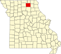
| State | Missouri |
| County | Adair |
| Area | |
• Total | 54.16 sq mi (140.28 km2) |
| • Land | 54.14 sq mi (140.23 km2) |
| • Water | 0.019 sq mi (0.05 km2) 0.03% |
| Elevation | 902 ft (275 m) |
| Population (2010) | |
• Total | 503 |
| • Density | 9.3/sq mi (3.6/km2) |
| FIPS code | 29-80134 [2] |
| GNIS feature ID | 0766219 |
Wilson Township is one of ten townships in Adair County, Missouri, United States. As of the 2010 census, its population was 503. [3] It is named for Joseph Wilson, an early judge in Adair County. [4]