
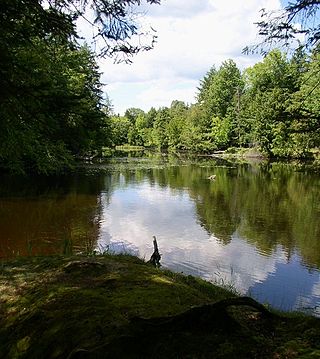
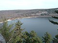
Devil's Lake State Park is a state park located in the Baraboo Range in eastern Sauk County, just south of Baraboo, Wisconsin. It is around thirty-five miles northwest of Madison, and is on the western edge of the last ice-sheet deposited during the Wisconsin glaciation. The state park encompasses 9,217 acres (3,730 ha), making it the largest in Wisconsin. The state park is known for its 500-foot-high (150 m) quartzite bluffs along the 360-acre (150 ha) Devil's Lake, which was created by a glacier depositing terminal moraines that plugged the north and south ends of the gap in the bluffs during the last ice age approximately 12,000 years ago. The sand at the bottom of Devil's Lake is thought to be deposited by glaciers.
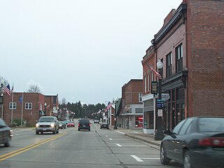
Karen Cecile DeSanto is an American educator, Democratic politician, and former entertainer from Baraboo, Wisconsin. She is a member of the Wisconsin State Assembly, representing Wisconsin's 40th Assembly district since 2025. Earlier in her career, she performed with her former husband, Greg DeSanto, as professional circus clowns in a husband-and-wife act.

The Baraboo Range is a mountain range in Columbia County and Sauk County, Wisconsin. Geologically, it is a syncline fold consisting of highly eroded Precambrian metamorphic rock. It is about 25 miles (40 km) long and varies from 5 to 10 miles (16 km) in width. The Wisconsin River, previously traveling in a north to south direction, turns to the east just north of the range before making its turn to the west towards the Upper Mississippi River. The eastern end of the range was glaciated during the Wisconsinian glaciation, while the western half was not, and consequently, marks the eastern boundary of Wisconsin's Driftless Area.

This is a list of the National Register of Historic Places listings in Sauk County, Wisconsin. It is intended to provide a comprehensive listing of entries in the National Register of Historic Places that are located in Sauk County, Wisconsin. The locations of National Register properties for which the latitude and longitude coordinates are included below may be seen on a map.
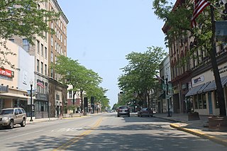
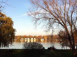
The 14th Senate district of Wisconsin is one of 33 districts in the Wisconsin Senate. Located in central Wisconsin, the district comprises all of Richland and Sauk counties, along with most of Columbia County and parts of southern Adams County, southern Juneau County, and northern Dane County. It contains the cities of Baraboo, Columbus, Portage, Reedsburg, Richland Center, and Wisconsin Dells, and the villages of DeForest, Lake Delton, Poynette, Prairie du Sac, and Sauk City, and part of the city of Madison. The district also contains landmarks such as Devil's Lake State Park, Dane County Regional Airport, Mirror Lake State Park, Lake Wisconsin and the Kilbourn Dam.

The 59th Assembly district of Wisconsin is one of 99 districts in the Wisconsin State Assembly. Located in eastern Wisconsin, the district comprises parts of northern Washington County, northern Ozaukee County, southern Sheboygan County, northeast Dodge County, and southeast Fond du Lac County. It includes the villages of Adell, Belgium, Campbellsport, Cedar Grove, Eden, Fredonia, Kewaskum, Random Lake, Saukville, and Theresa, along with part of the city of West Bend. It also contains the University of Wisconsin–Milwaukee at Washington County campus, the West Bend campus of Moraine Park Technical College, Kettle Moraine State Forest Northern Unit, Cedarburg Bog, Harrington Beach State Park, and most of the Theresa Marsh. The district is represented by Republican Robert Brooks, since January 2025.
The 60th Assembly district of Wisconsin is one of 99 districts in the Wisconsin State Assembly. Located in Eastern Wisconsin, the district comprises part of central Fond du Lac County, including the city of Fond du Lac and the village of North Fond du Lac. The district also contains Marian University, the University of Wisconsin–Oshkosh, Fond du Lac Campus, Taycheedah Correctional Institution, and the Fond du Lac County Airport. The district is represented by Republican Jerry L. O'Connor, since January 2025.

The 26th Assembly district of Wisconsin is one of 99 districts in the Wisconsin State Assembly. Located in eastern Wisconsin, the district comprises part of eastern Sheboygan County, including the city of Sheboygan. It also contains the University of Wisconsin–Green Bay, Sheboygan Campus and Kohler-Andrae State Park. The district is represented by Democrat Joe Sheehan, since January 2025.
The 27th Assembly district of Wisconsin is one of 99 districts in the Wisconsin State Assembly. Located in eastern Wisconsin, the district comprises much of Sheboygan County and parts of southeast Manitowoc County and northeast Fond du Lac County. It includes the cities of Sheboygan Falls, Plymouth, and Kiel, and the villages of Oostburg, Elkhart Lake, Howards Grove, and Kohler. It also contains Lakeland University, the Blackwolf Run golf course, the Road America motorsport course, and the Sheboygan County Memorial Airport. The district is represented by Republican Lindee Brill, since January 2025.
The 32nd Assembly district of Wisconsin is one of 99 districts in the Wisconsin State Assembly. Located in southeast Wisconsin, the district comprises most of Kenosha County and part of southeast Walworth County. It includes part of the city of Lake Geneva and the villages of Bloomfield, Paddock Lake, Salem Lakes, and Twin Lakes, and the southern half of the village of Pleasant Prairie. The district also contains the Richard Bong State Recreation Area and Chiwaukee Prairie Nature Preserve. The seat is represented by Republican Amanda Nedweski since January 2025.
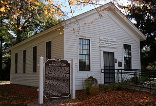
The 39th Assembly district of Wisconsin is one of 99 districts in the Wisconsin State Assembly. Located in central Wisconsin, the district comprises all of Green Lake and Marquette counties, along with much of western Fond du Lac County and parts of northeast Columbia County, southeast Winnebago County, and eastern Adams County. It includes the cities of Berlin, Green Lake, Markesan, Montello, Princeton, and Ripon. The district also contains Fox River National Wildlife Refuge, Summerton Bog, Ripon College and the historic Little White Schoolhouse in Ripon—the birthplace of the Republican Party. The district is represented by Republican Alex Dallman, since January 2025.

The 41st Assembly district of Wisconsin is one of 99 districts in the Wisconsin State Assembly. Located in west-central Wisconsin, the district comprises all of Richland County, much of the north half of Sauk County, and parts of southern Juneau County, southern Adams County, and northwest Columbia County. It includes the cities of Reedsburg, Richland Center, and Wisconsin Dells, and the villages of Boaz, Cazenovia, Ironton, La Valle, Lake Delton, Lime Ridge, Loganville, Lone Rock, Lyndon Station, North Freedom, Rock Springs, Union Center, Viola, Wonewoc, and Yuba. The district also contains the Dells of the Wisconsin River State Natural Area, Mirror Lake State Park, Dell Creek State Wildlife Area, the Mt. Olympus Water & Theme Park, and the Noah's Ark Water Park. The seat is represented by Republican Tony Kurtz since January 2025.

The 42nd Assembly district of Wisconsin is one of 99 districts in the Wisconsin State Assembly. Located in south-central Wisconsin, the district comprises most of the southern half of Columbia County and part of northern Dane County. It includes the cities of Columbus and Lodi, and the villages of Arlington, DeForest, Doylestown, Fall River, Poynette, and Rio, as well as part of the north side of the city of Madison including the Greater Sandburg, American Center, Pumpkin Hollow and Truax neighborhoods. The district also contains Dane County Regional Airport, Madison Area Technical College, and the American Family Insurance corporate headquarters. The district is represented by Democrat Maureen McCarville, since January 2025.

The 46th Assembly district of Wisconsin is one of 99 districts in the Wisconsin State Assembly. Located in southern Wisconsin, the district comprises most of the west half of Jefferson County and parts of eastern Dane County. It includes the cities of Fort Atkinson, Lake Mills, and Waterloo, and the villages of Cambridge, Deerfield, and Rockdale, along with nearly all of the village of Cottage Grove and part of the village of McFarland. The district also contains Aztalan State Park and the Goose Lake Wildlife Area. The district is represented by Democrat Melissa Ratcliff, since January 2023. Ratcliff did not run for re-election in 2024, and will be succeeded by Democrat Joan Fitzgerald in 2025.

The 57th Assembly district of the Wisconsin is one of 99 districts in the Wisconsin State Assembly. Located in central Wisconsin, the district comprises nearly all of Waushara County and most of the southern half of Waupaca County, along with parts of western Winnebago County, southwest Outagamie County, southeast Portage County, and eastern Adams County. It includes the cities of Manawa, Wautoma, Waupaca, and Weyauwega, and the villages of Almond, Coloma, Fremont, Hancock, Lohrville, Ogdensburg, Plainfield, Redgranite, and Wild Rose. The district also contains Hartman Creek State Park and historic sites such as Waupaca's Main Street Historic District and the King Wisconsin Veterans Home, established for veterans of the American Civil War, containing the Veterans Cottages Historic District, the Commandant's Residence Home, and the Veterans Home Chapel. The district is represented by Republican Kevin David Petersen, since January 2025.
The 68th Assembly district of Wisconsin is one of 99 districts in the Wisconsin State Assembly. Located in northwestern Wisconsin, the district comprises all of Price and Rusk counties, and most of Chippewa and Taylor counties. It includes the cities of Bloomer, Cornell, Ladysmith, Park Falls, and Phillips, and the villages of Bruce, Catawba, Conrath, Gilman, Glen Flora, Hawkins, Ingram, Kennan, Lublin, Prentice, Rib Lake, Sheldon, Tony, and Weyerhaeuser. The district also contains Lake Wissota State Park, Brunet Island State Park, and Timms Hill—the highest natural point in the state of Wisconsin. The district is represented by Republican Karen Hurd, since January 2023.
The 71st Assembly district of Wisconsin is one of 99 districts in the Wisconsin State Assembly. Located in central Wisconsin, the district comprises most of Portage County and part of northeast Adams County. It includes the city of Stevens Point and the villages of Amherst, Amherst Junction, Nelsonville, Plover, and Whiting. The district also contains the University of Wisconsin–Stevens Point campus. The district is represented by Democrat Katrina Shankland, since January 2013. Shankland did not run for re-election in 2024 and will be succeeded by Democrat Vinnie Miresse in 2025.

The 75th Assembly district of Wisconsin is one of 99 districts in the Wisconsin State Assembly. Located in northwestern Wisconsin, the district comprises all of Polk County and most of Burnett County. It includes the cities of Amery and St. Croix Falls and the villages of Balsam Lake, Centuria, Clayton, Clear Lake, Dresser, Frederic, Grantsburg, Luck, Milltown, Osceola, Siren, and Webster, and part of the village of Turtle Lake. The district also contains the St. Croix Chippewa reservation, the Wisconsin portion of Interstate Park, and a significant portion of the Wisconsin side of the Saint Croix National Scenic Riverway. The district is represented by Republican David Armstrong, since January 2021. Armstrong was drawn out of the district by the 2024 redistricting act, Republican Duke Tucker was elected to represent the new district beginning in January 2025.
The 87th Assembly district of Wisconsin is one of 99 districts in the Wisconsin State Assembly. Located in northwest Wisconsin, the district comprises the southeastquarter of Marathon County and much of the northern half of Waupaca County, along with parts of northeast Portage County and western Shawano County. It includes the cities of Mosinee, Marion, and Schofield, and the villages of Big Falls, Birnamwood, Eland, Elderon, Hatley, Iola, Rosholt, Rothschild, Scandinavia, Tigerton, and Wittenberg. The district also contains Rib Mountain State Park and Central Wisconsin Airport The district is represented by Republican James W. Edming, since January 2015.

The 92nd Assembly district of Wisconsin is one of 99 districts in the Wisconsin State Assembly. Located in western Wisconsin, the district comprises parts of southwest Chippewa County and central Dunn County. It includes the cities of Chippewa Falls and Menomonie and the parts of Eau Claire which fall in Chippewa County, along with the villages of Elk Mound and Lake Hallie. The district is represented by Republican Treig Pronschinske, since January 2017.


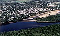 Aerial view of Portage


