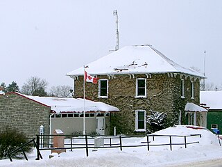
Perth is a town in Eastern Ontario, Canada. It is located on the Tay River, 83 kilometres (52 mi) southwest of Ottawa, and is the seat of Lanark County.

Mississippi Mills is a town in eastern Ontario, Canada, in Lanark County on the Mississippi River. It is made up of the former Townships of Ramsay and Pakenham, as well as the Town of Almonte. It is partly located within Canada's National Capital Region.

Westport is a village in Eastern Ontario, Canada. It lies at the west end of Upper Rideau Lake, at the head of the navigable Rideau Canal system, 100 km (62 mi) southwest of Ottawa.

The Township of Wellesley is the rural, north-western township of the Regional Municipality of Waterloo in Ontario, Canada. It encompasses 277.79 km2 (107.26 sq mi) and had a population of 11,260 in the Canada 2016 Census.

Tiverton is a community in the Municipality of Kincardine, Bruce County, Ontario, Canada. It is near the shore of Lake Huron on Highway 21 between Port Elgin and Kincardine.
Hampton is a community located in the municipality of Clarington, Ontario, Canada. It was the location of the offices of Darlington Township until 1974 when it became part of the newly created Town of Newcastle as part of the municipal government restructuring that created the Regional Municipality of Durham.
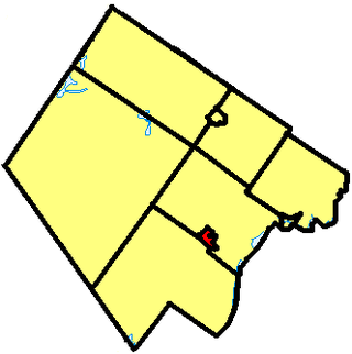
Elizabethtown-Kitley is a township in eastern Ontario, Canada, in the United Counties of Leeds and Grenville. Its southern border lies along the St. Lawrence River and it extends north into many rural hamlets and villages. The township was created on January 1, 2001, by the amalgamation of the former Township of Elizabethtown and Township of Kitley.
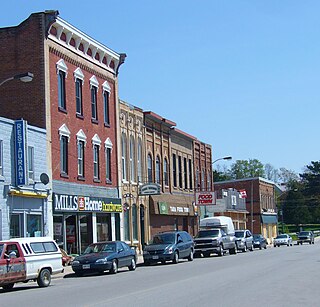
Tara is an unincorporated community in the municipality of Arran–Elderslie, Bruce County, in southwestern Ontario, Canada. It is a designated place and had 1,037 residents and 458 dwellings as of the 2011 census. Tara is in geographic Arran Township and is located on the Sauble River. It has an area of 2.39 square kilometres (0.92 sq mi) and an urban area that covers 63.5 square kilometres (24.5 sq mi).
Blyth is a village in North Huron, Ontario, Canada.
Delia is a village in southern Alberta, Canada. It is approximately 45 km (28 mi) northeast of Drumheller, 1.6 km (0.99 mi) south of Highway 9. It is named for Delia Davis, wife of Alvin L. Davis, a local merchant, and was originally known as the Village of Highland between 1914 and 1915, though the post office was called Delia from its inception in 1912.

Endiang is a hamlet in Alberta, Canada within the County of Stettler No. 6. It is located approximately 80 kilometres (50 mi) southeast of Stettler.

Baldwin is a township in the Canadian province of Ontario. Located in Sudbury District north of Espanola, the township's two main communities and population centres are McKerrow and Lorne.
Rideau Lakes is a township located within Leeds and Grenville United Counties in Eastern Ontario, Canada. The township was incorporated on 1 January 1998 by amalgamating the former townships of North Crosby, South Crosby, Bastard, South Burgess and South Elmsley with the village of Newboro.
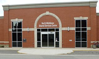
North Middlesex is a municipality in Middlesex County, Ontario, Canada.
Carseland is a hamlet in Alberta, Canada within Wheatland County. It is located on Highway 24, approximately 23 km (14 mi) south of Cheadle and 26 km (16 mi) south of Strathmore.

Roseville is a community in Ontario, Canada located at 43°20′35″N80°28′31″W. It is within the rural township of North Dumfries, which forms part of the Region of Waterloo, and is located between Ayr, Kitchener and Highway 401.

Thornloe is a village in the Canadian province of Ontario, located in the Timiskaming District. The village had a population of 92 in the 2021 Canadian Census.

Stone Mills is a lower-tier township north of Greater Napanee in Lennox and Addington County, Ontario, Canada. According to the 2016 census, the township has a population of 7,702.

Conestogo is a community in the Canadian province of Ontario, located in the township of Woolwich in Waterloo Region. The population in 2016 was 1,270.

Richard is a village in the Canadian province of Saskatchewan within the Rural Municipality of Douglas No. 436 and Census Division No. 16. It is approximately 48 km (30 mi) east of the City of North Battleford.


