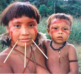
The Ye'kuana, also called Ye'kwana, Ye'Kuana, Yekuana, Yequana, Yecuana, Dekuana, Maquiritare, Makiritare, So'to or Maiongong, are a Cariban-speaking tropical rain-forest tribe who live in the Caura River and Orinoco River regions of Venezuela in Bolivar State and Amazonas State. In Brazil, they inhabit the northeast of Roraima State. In Venezuela, the Ye'kuana live alongside their former enemies, the Sanumá (Yanomami subgroup).
When the Ye'kuana wish to refer to themselves, they use the word So'to, which can be translated as "people", "person". Ye’kuana, in turn, can be translated as "canoe people", "people of the canoes"[3] or even "people of the branch in the river".
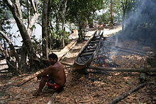
They live in communal houses called Atta or ëttë. The circular structure has a cone-shaped roof made of palm leaves. Building the atta is considered a spiritual activity in which the group reproduces the great cosmic home of the Creator.
The first reference to the Ye'kuana was in 1744 by a Jesuit priest called Manuel Román in his travels to investigate the existence of the Casiquiare canal.[4] He recruited the services of the Ye'kuana to help him on his way.
The Alto Orinoco-Casiquiare Biosphere Reserve was established by the Venezuelan government in 1993 with the objective of preserving the traditional territory and lifestyle of the Yanomami and Ye'kuana peoples.[5] There are some 6,250 Ye'kuana in Venezuela, according to the 2001 census, with some 430 in Brazil.
Jean Liedloff came into contact with the Ye'kuana in the 1950s, while working as a photographer for Italian diamond-hunters, and in subsequent personal visits. She based her book The Continuum Concept: In Search of Happiness Lost on their way of life, particularly the upbringing of their children. Liedloff noted the stark contrast between the treatment of Western and Ye'kuana infants, who are normally held "in-arms" 24 hours a day by their mothers and by other familiar adults and children who take care of them.[6]
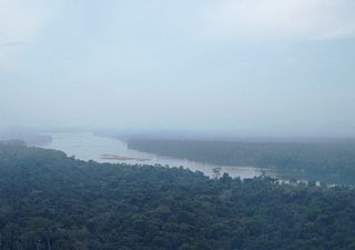
The Casiquiare river or canal is a natural distributary of the upper Orinoco flowing southward into the Rio Negro, in Venezuela, South America. As such, it forms a unique natural canal between the Orinoco and Amazon river systems. It is the world's largest river of the kind that links two major river systems, a so-called bifurcation. The area forms a water divide, more dramatically at regional flood stage.
The Orinoco is one of the longest rivers in South America at 2,140 km (1,330 mi).
Amazonas State is one of the 23 states into which Venezuela is divided. It covers nearly a fifth of the area of Venezuela, but has less than 1% of Venezuela's population.
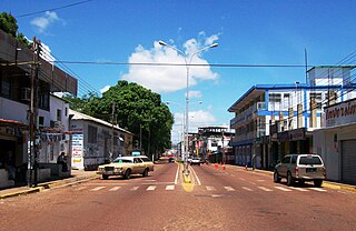
Puerto Ayacucho is the capital and largest city of Amazonas State in Venezuela. Puerto Ayacucho is located across the Orinoco River from the Colombian village of Casuarito.
San Carlos de Río Negro is a town in Venezuela's Amazonas State.
La Esmeralda is a small settlement in and the capital of Alto Orinoco Municipality in Venezuela’s Amazonas State. The name means “the emerald”. It is located on the shore of the Orinoco river, only 9 miles from the Casiquiare canal bifurcation that links it to the Amazon River.
The Sanumá, also referred to as Sanema, Sanima Tsanuma, Guaika, Samatari, Samatali, Xamatari and Chirichano in the literature, are an indigenous people of Brazil and Venezuela. They are related to the Yanomami.
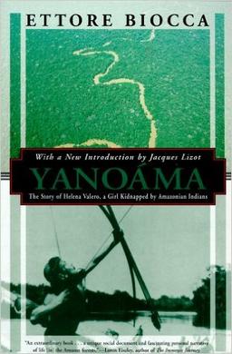
Yanoama: The Story of Helena Valero, a Girl Kidnapped by Amazonian Indians is a biography of Helena Valero, a mixed-race mestizo woman who was captured in the 1930s as a girl by the Kohorochiwetari, a tribe of the Yanomami indigenous people, living in the Amazon rainforest on the border between Venezuela and Brazil. She lived with the Yanomami for about two decades. While living with the Yanoama, Valero married twice and gave birth to four children. She escaped in 1956 to what she refers to as "the white man" in the country of her birth. After rejection by her family and living in poverty at a mission, Valero chose to return to life with the Yanomami.
Sanöma or Sanumá is a Yanomaman language spoken in Venezuela and Brazil. It is also known as Sanema, Sanima, Tsanuma, Guaika, Samatari, Samatali, Xamatari and Chirichano. Most of its speakers in Venezuela also speak Ye'kuana, also known as Maquiritare, the language of the Ye'kuana people the Sanumá live alongside in the Caura River basin.
The Yanomami, also spelled Yąnomamö or Yanomama, are a group of approximately 35,000 indigenous people who live in some 200–250 villages in the Amazon rainforest on the border between Venezuela and Brazil.
Alexander Hamilton Rice Jr. was an American physician, geographer, and explorer of the Amazon Basin. He was a professor of geography at Harvard University from 1929 to 1952. He was also founder and director of the Harvard Institute of Geographical Exploration and curator of the South American section of the Peabody Museum of Archaeology and Ethnology.
Indigenous people in Venezuela, Amerindians or Native Venezuelans, form about 2% of the population of Venezuela, although many Venezuelans are mixed with Indigenous ancestry. Indigenous people are concentrated in the Southern Amazon rainforest state of Amazonas, where they make up nearly 50% of the population and in the Andes of the western state of Zulia. The most numerous indigenous people, at about 200,000, is the Venezuelan part of the Wayuu people who primarily live in Zulia between Lake Maracaibo and the Colombian border. Another 100,000 or so indigenous people live in the sparsely populated southeastern states of Amazonas, Bolívar and Delta Amacuro.
Ye'kuana, also known as Maquiritari, Dekwana, Ye'kwana, Ye'cuana, Yekuana, Cunuana, Kunuhana, De'cuana, De’kwana Carib, Pawana, Maquiritai, Maquiritare, Maiongong, or Soto is the language of the Ye'kuana people of Venezuela and Brazil. It is a Cariban language. It is spoken by approximately 5,900 people around the border of northwestern Brazilian state of Roraima and Venezuela – the majority in Venezuela. At the time of the 2001 Venezuelan census, there were at 6,523 Ye’kuana living in Venezuela. Given the unequal distribution of the Ye’kuana across two South American countries, Ethnologue lists two different vitality ratings for Ye’kuana: in Venezuela it is listed as Vigorous (6a), while in Brazil it is classified Moribund (8a) on the Graded Intergenerational Disruption Scale (GIDS).
The Huni Kuin are an Indigenous people of Brazil and Peru. Their villages are located along the Purus and Curanja Rivers in Peru and the Tarauacá, Jordão, Breu, Muru, Envira, Humaitã, and Purus Rivers in Brazil.
The genocide of indigenous peoples in Brazil began with the Portuguese colonization of the Americas, when Pedro Álvares Cabral made landfall in what is now the country of Brazil in 1500. This started the process that led to the depopulation of the indigenous peoples in Brazil, because of disease and violent treatment by Portuguese settlers, and their gradual replacement with colonists from Europe and enslaved peoples from Africa. This process has been described as a genocide, and continues into the modern era with the ongoing destruction of indigenous peoples of the Amazonian region.
The Baré, or Hanera, and Werekena are related indigenous people of northwest Brazil and Venezuela. For many years they suffered from violent exploitation by Portuguese and Spanish merchants, forced to work as debt slaves. They moved often to try to avoid the merchants. Today most live by agriculture, hunting, fishing and gathering, and extract piassava fiber for income to buy goods from traders.
The Yanomami Indigenous Territory is an indigenous territory in the states of Amazonas and Roraima, Brazil. It overlaps with several federal or state conservation units. It is home to Yanomami and Ye'kuana people. There are ongoing conflicts with an overlapping national forest in which mining was permitted.
The Negro–Branco moist forests (NT0143) is an ecoregion of tropical moist broadleaf forest to the east of the Andes in southern Venezuela, eastern Colombia and northern Brazil, in the Amazon biome. It lies on the watershed between the Orinoco and Rio Negro basins. It includes both blackwater and whitewater rivers, creating different types of seasonally flooded forest. The vegetation is more typical of the Guiana region than the Amazon.
The Alto Orinoco-Casiquiare Biosphere Reserve is a UNESCO biosphere reserve in the Venezuelan Amazon biome.
The Orinoco Mining Arc (OMA), is a resource-rich area in Venezuela that has become a hub for illegal mining. It was opened to development in February 2016 as the "Orinoco Mining Arc National Strategic Development Zone", and has been operating since 2017; The Orinoco Mining Arc covers 12.2% of Venezuelan territory with an area of 111,843 km2. Gold is the most important resource in the area, and there are also deposits of bauxite, coltan, and diamonds. According to former minister Roberto Mirabal, the Mining Arc has a potential mineral value of $2 trillion US dollars.
This page is based on this Wikipedia article Text is available under the CC BY-SA 4.0 license; additional terms may apply. Images, videos and audio are available under their respective licenses.