Alberta's Rockies

Last updated

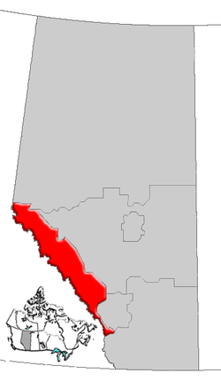
Alberta's Rockies comprise the Canadian Rocky Mountains in Alberta, Canada. On the southwestern part of the province along the British Columbia border, the region covers all but the south of Census Division 15.

Contents

Northern
Alberta
Alberta's
Rockies
Southern
Alberta
Calgary
Region
Edmonton
Region
Central Alberta
Alberta-rockies map.png

The main industry in this region is tourism. [1]

Geography

Maligne Lake in Jasper National Park Maligne Lake at night.jpg
Maligne Lake in Jasper National Park
View on the Icefields Parkway in Banff National Park The View from the Summit of Mount Weed on the Icefields Parkway in Banff National Park.jpg
View on the Icefields Parkway in Banff National Park

This human region is almost identical to the Alberta Mountain forests ecozone. The region contains the Central Front Ranges and the Continental Ranges of the Canadian Rocky Mountains, and includes the Banff National Park and Jasper National Park, as well as the Kananaskis Country park system and the Willmore Wilderness. [2]

The main transportation corridors run through the Kicking Horse Pass and the Yellowhead Pass from east to west, while the Bow Valley and Athabasca River valley are followed by the longitudinal Icefields Parkway. Another important waterway that crosses this region is the North Saskatchewan River.

Tourism

Some of the best ski resorts of the Rockies are located in this region, and are important tourist destinations. They include Fortress Mountain Resort, Lake Louise, Marmot Basin, Mount Norquay, Nakiska and Sunshine Village. Other tourist attractions include the glaciers of the Columbia, Wapta and Waputik Icefields such as the Athabasca, Bow, Crowfoot, Hector, Peyto, Saskatchewan and Vulture Glaciers.

Glacial lakes line the Icefields Parkway and dot the surrounding valleys. Some of the more spectacular are Bow, Hector, Louise, Maligne, Moraine, Peyto, Pyramid and Vermilion lakes.

Infrastructure

Banff and Jasper are the main communities in the region. The length is defined by the Icefields Parkway, and it is crossed by the Trans-Canada Highway and the Yellowhead Highway into British Columbia. David Thompson Highway leads from the Rockies into central Alberta from Saskatchewan River Crossing, and Banff Windermere Parkway leads from Castle Junction (south of Lake Louise) through the Kootenay National Park to the Columbia River valley. The Bighorn Highway defines most of the eastern limit of the region.

Health care has been the responsibility of Alberta Health Services, since the province's health regions were amalgamated in 2008. Before then, Calgary Health Region was the health region ensuring well-being in the south of this region, [3] while the north was supervised by the Aspen Regional Health Authority. [4]

Health care centres established in the area are:

Politics

On a provincial level, southern Alberta is represented in the Legislative Assembly of Alberta by MLA's elected in the ridings of Banff-Cochrane and part of Rocky Mountain House and West Yellowhead.

Communities

The following communities are located in Alberta's Rockies.

The towns of Grande Cache and Hinton, located on the eastern edge of the Rockies, are sometimes considered as part of this region. [5]

The following rural municipalities are located in Alberta's Rockies.

See also

Related Research Articles

Jasper National Park National park in Alberta, Canada

Jasper National Park is a national park in Alberta, Canada. It is the largest national park within Alberta's Rocky Mountains spanning 11,000 km2 (4,200 sq mi). Its location is north of Banff National Park and west of Edmonton. The park contains the glaciers of the Columbia Icefield, springs, lakes, waterfalls and mountains.

Banff National Park National park in Alberta, Canada

Banff National Park is Canada's oldest national park, established in 1885. Located in Alberta's Rocky Mountains, 110–180 kilometres (68–112 mi) west of Calgary, Banff encompasses 6,641 square kilometres (2,564 sq mi) of mountainous terrain, with many glaciers and ice fields, dense coniferous forest, and alpine landscapes. The Icefields Parkway extends from Lake Louise, connecting to Jasper National Park in the north. Provincial forests and Yoho National Park are neighbours to the west, while Kootenay National Park is located to the south and Kananaskis Country to the southeast. The main commercial centre of the park is the town of Banff, in the Bow River valley.

Lake Louise, Alberta Hamlet in Alberta, Canada

Lake Louise is a hamlet within Banff National Park in Alberta, Canada. Named after Princess Louise, Duchess of Argyll, it lies in Alberta's Rockies on the Bow River, 3 km (1.9 mi) northeast of the lake that shares its name. Initially settled in 1884 as an outpost for the Canadian Pacific Railway, Lake Louise sits at an elevation of 1,600 m (5,200 ft), making it Canada's highest community. The nearby lake, framed by mountains, is one of the most famous mountain vistas in the world; the famous Chateau Lake Louise also overlooks the lake.

Mount Alberta Mountain in Jasper NP, Alberta, Canada

Mount Alberta is a mountain located in the upper Athabasca River Valley of Jasper National Park, Alberta, Canada. J. Norman Collie named the mountain in 1898 after Princess Louise Caroline Alberta. It is the most difficult of the 11,000ers from a climbing point of view.

Jasper, Alberta Specialized municipality in Alberta, Canada

Jasper is a specialized municipality in western Alberta, Canada. It is the commercial centre of Jasper National Park, located in the Canadian Rockies within the Athabasca River valley. Jasper is approximately 362 kilometres (225 mi) west of Edmonton and 290 kilometres (180 mi) north of Banff, Alberta, at the intersection of Highway 16 and Highway 93.

Columbia Icefield

The Columbia Icefield is the largest ice field in North America's Rocky Mountains. Located within the Canadian Rocky Mountains astride the Continental Divide along the border of British Columbia and Alberta, Canada, the ice field lies partly in the northwestern tip of Banff National Park and partly in the southern end of Jasper National Park. It is about 325 square kilometres (125 sq mi) in area, 100 metres (330 ft) to 365 metres (1,198 ft) in depth and receives up to 7 metres (280 in) of snowfall per year.

Peyto Lake

Peyto Lake is a glacier-fed lake in Banff National Park in the Canadian Rockies. The lake itself is near the Icefields Parkway. It was named for Bill Peyto, an early trail guide and trapper in the Banff area.

Alberta Provincial Highway No. 16, commonly referred to as Highway 16, is a major east–west highway in central Alberta, Canada, connecting Jasper to Lloydminster via Edmonton. It forms a portion of the Yellowhead Highway, a major interprovincial route of the Trans-Canada Highway system that stretches from Masset, British Columbia to Portage la Prairie, Manitoba, near Winnipeg. Highway 16 spans approximately 634 km (394 mi) from Alberta's border with British Columbia in the west to its border with Saskatchewan in the east. As of 2010, all but less than 96 km (60 mi) of the route was divided, with a minimum of two lanes in each direction. It is designated a core route in Canada's National Highway System.

Alberta Provincial Highway No. 1, commonly referred to as Highway 1, is a major east–west highway in Southern Alberta that forms the southern mainline of the Trans-Canada Highway. It runs from the British Columbia border near Lake Louise through Calgary to the Saskatchewan border east of Medicine Hat. It continues as Highway 1 into both provinces. It spans approximately 534 km (332 mi) from Alberta's border with British Columbia in the west to its border with Saskatchewan in the east. The route is a divided 4 lane expressway throughout the province with the exception of a section in central Calgary where it is an arterial thoroughfare and Urban Boulevard carrying 4 to 6 lanes. The highway is a freeway between the Sunshine exit near the town of Banff and Home Road in Calgary. Other rural sections have at grade intersections with Interchanges only at busier junctions. Twinning of the final 8.5 km (5.3 mi) of Highway 1 between Lake Louise and the British Columbia border was completed by Parks Canada and opened to traffic on June 12, 2014 making the whole length of Alberta Highway 1 a divided minimum 4 lane route.

Alberta Highway 1A Designation for two disconnected sections of provincial highway in Alberta, Canada

Alberta Provincial Highway No. 1A is the designation of two alternate routes off the Alberta portion of Trans-Canada Highway 1. However, it is not the only name used for spurs off Highway 1 - Highway 1X is another such designation. Despite these highways being suffixed routes of Highway 1, they are not part of the Trans-Canada Highway network, and are signed with Alberta's provincial primary highway shields instead of the Trans-Canada shields used for Highway 1.

Alberta Highway 93 Provincial highway in Banff and Jasper national parks in Alberta, Canada

Highway 93 is a north-south highway in Alberta, Canada. It is also known as the Banff-Windermere Parkway south of the Trans-Canada Highway (Highway 1) and the Icefields Parkway north of the Trans-Canada Highway. It travels through Banff National Park and Jasper National Park and is maintained by Parks Canada for its entire length. It runs from the British Columbia border at Vermilion Pass in the south, where it becomes British Columbia Highway 93, to its terminus at the junction with the Yellowhead Highway (Highway 16) at Jasper. The route takes its number from U.S. Route 93, which runs uninterrupted south to central Arizona, and was initially designated as '93' in 1959.

Peyto Peak Mountain in Banff NP, Canada

Peyto Peak is a mountain in the Waputik Range, part of the Canadian Rockies in Alberta, Canada. It lies at the north end of the Wapta Icefield, in Banff National Park, about one km (0.6 mi) east of the border with British Columbia and 32 km (20 mi) north of the town of Field. Five kilometres to the northeast lies Bow Pass, one of the high points of the Icefields Parkway. Between the peak and the pass lies picturesque Peyto Lake. Three kilometres southwest of Peyto Peak is Mount Baker, the highest point in the immediate vicinity.

Tourism in Alberta

Alberta has been a tourist destination since the early days of the 20th Century, with attractions including national parks, National Historic Sites of Canada, urban arts and cultural facilities, outdoor locales for skiing, hiking and camping, shopping locales such as West Edmonton Mall, outdoor festivals, professional athletic events, international sporting competitions such as the Commonwealth Games and Olympic Winter Games, as well as more eclectic attractions.

Bow Lake (Alberta)

Bow Lake is a small lake in western Alberta, Canada. It is located on the Bow River, in the Canadian Rockies, at an altitude of 1920 m.

Hector Lake

Hector Lake is a small glacial lake in western Alberta, Canada. It is located on the Bow River, in the Waputik Range of the Canadian Rockies.

Saskatchewan River Crossing, Alberta

Saskatchewan River Crossing is a locality in western Alberta, Canada. It is located within Banff National Park at the junction of Highway 93 and Highway 11. It is administered by Improvement District No. 9.

Sunwapta Pass

Sunwapta Pass is a mountain pass in the Canadian Rockies in the province of Alberta. Sunwapta Pass is the low point of the saddle created between Mount Athabasca and Nigel Peak. The pass marks the boundary between Banff and Jasper National Parks. The Icefields Parkway travels through Sunwapta Pass 108 km (67 mi) southeast of the town of Jasper and 122 km (76 mi) northwest of the Parkway's junction with the Trans-Canada Highway near Lake Louise. The pass is the second highest point on the Icefields Parkway. Bow Summit in Banff National Park is the highest point on the parkway.

The Banff-Windermere Highway, also known as the Banff-Windermere Parkway, is a 105 km (65 mi) highway which runs through the Canadian Rockies in British Columbia and Alberta in Canada. It runs from Radium Hot Springs, British Columbia to Castle Junction, Alberta, passing through Kootenay National Park and Banff National Park. It is designated as part of British Columbia Highway 93 and Alberta Highway 93.

Mount Jimmy Simpson

Mount Jimmy Simpson is a 2,966-metre (9,731-foot) summit located 3 kilometres northwest of Bow Lake in Banff National Park, in the Canadian Rockies of Alberta, Canada. Its nearest higher peak is Mount Thompson, 3.0 km (1.9 mi) to the southwest. Mount Jimmy Simpson is a member of the Waputik Mountains, and is situated east of the Wapta Icefield and west of the Bow River valley. Mount Jimmy Simpson can be seen from the Icefields Parkway at Bow Lake. Jimmy Simpson Junior is a 2,721 meter sub-summit east of the mountain.

References

  1. Travel Alberta. Alberta's Rockies Archived 2007-06-18 at the Wayback Machine
  2. Alberta Heritage. Alberta Regions Archived February 6, 2012, at the Wayback Machine
  3. Calgary Health Region. "Hospitals". Archived from the original on 18 June 2007. Retrieved 2007-06-24.
  4. Aspen Regional Health. "Healthcare centres" . Retrieved 2007-06-24.
  5. AMA. "Mountain Parks Region". Archived from the original on 30 June 2007. Retrieved 2007-06-24.

Coordinates: 52°00′N116°30′W / 52.0°N 116.5°W / 52.0; -116.5 (Alberta's Rockies)