
Richmond is the capital city of the Commonwealth of Virginia in the United States. Incorporated in 1742, Richmond has been an independent city since 1871. The city's population in the 2020 census was 226,610, up from 204,214 in 2010, making it Virginia's fourth-most populous city. The Richmond metropolitan area, with over 1.3 million residents, is the Commonwealth's third-most populous.

Manchester is a former independent city in Virginia in the United States. Prior to receiving independent status, it served as the county seat of Chesterfield County, between 1870 and 1876. Today, it is a part of the city of Richmond, Virginia.

Broad Street is a 15-mile-long (24 km) road located in the independent city of Richmond, Virginia, and adjacent Henrico County. Broad Street is significant to Richmond due to the many commercial establishments that have been built along it throughout Richmond's history. From downtown through miles into the suburbs, the street is largely dedicated to retailing and offices, including regional and neighborhood shopping centers and malls.

The Federal Reserve Bank of San Francisco is the federal bank for the twelfth district in the United States. The twelfth district is made up of nine western states—Alaska, Arizona, California, Hawaii, Idaho, Nevada, Oregon, Utah, and Washington—plus the Northern Mariana Islands, American Samoa, and Guam. The San Francisco Fed has branch offices in Los Angeles, Portland, Salt Lake City, and Seattle. It also has a cash processing center in Phoenix.
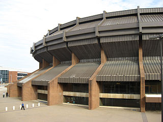
Richmond Coliseum is a defunct arena located in downtown Richmond, Virginia, with a capacity of 13,500 that was most often used for various large concerts. The arena opened in 1971 and the region is looking to replace the aging facility with a larger one. The arena was quietly shuttered in February 2019 while new proposed replacements are in development.

City Stadium is a sports stadium in Richmond, Virginia. It is owned by the City of Richmond and is located south of the Carytown district off the Downtown Expressway. The stadium was built in 1929 and seats approximately 22,000 people when both stands are used. It has been used by the Richmond Kickers of USL League One since 1995, at a capacity of 6,000.
The Federal Reserve Bank of Dallas covers the Eleventh Federal Reserve District of the United States, which includes Texas, northern Louisiana and southern New Mexico, a district sometimes referred to as the Oil Patch. The Federal Reserve Bank of Dallas is one of 12 regional Reserve Banks that, along with the Board of Governors in Washington, D.C., make up the U.S. central bank. The Dallas Fed is the only one where all external branches reside in the same state . The Dallas Fed has branch offices in El Paso, Houston, and San Antonio. The Dallas bank is located at 2200 Pearl St. in the Uptown neighborhood of Oak Lawn, just north of downtown Dallas and the Dallas Arts District. Prior to 1992, the bank was located at 400 S. Akard Street, in the Government District in Downtown Dallas. The older Dallas Fed building, which opened in 1921, was built in the Beaux-arts style, with large limestone structure with massive carved eagles and additional significant detailing; it is a City of Dallas Designated Landmark structure. The current Dallas Fed building, opened in September 1992, was designed by three architectural firms: Kohn Pedersen Fox Associates, New York; Sikes Jennings Kelly & Brewer, Houston; and John S. Chase, FAIA, Dallas and Houston, Dallas-based Austin Commercial Inc. served as project manager and general contractor.
The Federal Reserve Bank of Richmond is the headquarters of the Fifth District of the Federal Reserve located in Richmond, Virginia. It covers the District of Columbia, Maryland, North Carolina, South Carolina, Virginia, and most of West Virginia excluding the Northern Panhandle. Branch offices are located in Baltimore, Maryland and Charlotte, North Carolina. Thomas I. Barkin became president of the Richmond Fed following the retirement of Jeffrey M. Lacker in April 2017. The previous president, J. Alfred Broaddus, retired in 2004.

Richmond Veterans Administration Medical Center, formerly known as Hunter Holmes McGuire VA Medical Center or McGuire VA Hospital, is located in Richmond, Virginia.

The Tri-Cities of Virginia is an area in the Greater Richmond Region which includes the three independent cities of Petersburg, Colonial Heights, and Hopewell and portions of the adjoining counties of Chesterfield, Dinwiddie, and Prince George in south-central Virginia. Other unincorporated communities located in the Tri-Cities area include Ettrick, Fort Gregg-Adams, and City Point, the latter formerly a historic incorporated town which was annexed to become part of the City of Hopewell.

Downtown Richmond is the central business district of Richmond, Virginia, United States. It is generally defined as being bound by Belvidere Street to the west, I-95 to the north and east, and the James River to the south. The Fan district borders it to the west, Highland Park to the north, Church Hill to the east, and Manchester to the south.

The Port of Richmond, also known as the Richmond Deepwater Terminal, is located on the James River in Richmond, Virginia, United States, 100 miles (160 km) inland from Cape Henry and approximately 78 miles (126 km) northwest of Newport News, Virginia. It is located at 77° 25' west latitude and 37° 27' north longitude and lies adjacent to Interstate 95. The port is the western terminus for commercial navigation on the James River and is 4 miles (6 km) south of downtown Richmond. The port was built in 1940.

Interstate 95 (I-95) runs 179 miles (288 km) within the commonwealth of Virginia between its borders with North Carolina and Maryland. I-95 meets the northern terminus of I-85 in Petersburg and is concurrent with I-64 for three miles (4.8 km) in Richmond. Although I-95 was originally planned as a highway through Washington, D.C., it was rerouted along the eastern portion of the Capital Beltway concurrent with I-495. From Petersburg to Richmond, I-95 utilized most of the Richmond–Petersburg Turnpike, a former toll road. In addition to Richmond, the route also runs through the medium-sized cities of Emporia, Petersburg, Colonial Heights, Fredericksburg, and Alexandria.
Court End is a neighborhood in Richmond, Virginia, that sits to the north of the Capitol Square and East Broad Street. It developed in the Federal era, after Virginia's capital moved from Williamsburg.
The Federal Reserve Bank of Cleveland Pittsburgh Branch Office is one of two Federal Reserve Bank of Cleveland branch offices. The Pittsburgh Office of the Federal Reserve Bank of Cleveland hosts one of two savings bonds processing sites in the nation. The Pittsburgh branch presides over Jefferson, Monroe and Belmont counties in Ohio, Wetzel, Tyler, Pleasants, Marshall, Ohio, Brooke and Hancock counties in West Virginia, and all of Western Pennsylvania. In 1915 it was revealed that the Pittsburgh branch location was to be the new home of a relocated Cleveland Fed District with a majority vote secured on the board of governors, but the U.S. Attorney General at the time nixed moving the Cleveland, Kansas City, Minneapolis, Boston and Atlanta Federal Reserve Districts, stating that it would instead take an act of Congress to move those district headquarters. Pittsburgh remained a branch location only.

The Richmond Arts and Culture District stretches from the Institute for Contemporary Art on West Broad to the Virginia State Capitol and spans the Monroe Ward and Jackson Ward neighborhoods. The Arts District was designed to be the center of artistic, cultural, civic, and commercial activity. This district has worked to promote economic prosperity in this area of Richmond and create areas for art galleries and artist living spaces. This inclusive district offers a variety of experiences for all visitors and locals. The Arts District features and supports the history of the Jackson Ward neighborhood, the business activity along West Broad Street, the wide range of downtown art galleries, and eclectic dining and shopping experiences. The District is the first of its kind in the city of Richmond but state law allows there to be more than Arts District in each city.
The Biotech and MCV District is the community that surrounds the MCV Campus of Virginia Commonwealth University in Downtown Richmond, Virginia.
Old Town Manchester is a neighborhood in Richmond, Virginia's Southside quadrant. The neighborhood is where downtown Manchester, Richmond, Virginia, United States, was situated before the city merged with Richmond. The area is heavily industrialized, but has gone through a series of gentrification for the last 10 years. Several lofts and art galleries have opened in the area.
Randolph is a historically black middle class neighborhood located within the West End of Richmond, Virginia. The neighborhood is named in honor of Virginia E. Randolph, a former African-American educator in Henrico County, Virginia during the 19th century. The neighborhood is bounded by the Downtown Expressway to the north, Harrison Street to the east, Colorado Avenue to the south, and South Meadow street to the west. Some famous landmarks and places of interest in the neighborhood include Petronius Park, the Randolph Community Center, and just adjacent to the neighborhood, the Hollywood Cemetery.

