U.S. Route 250 is a route of the United States Numbered Highway System, and is a spur of U.S. Route 50. It currently runs for 514 miles (827 km) from Richmond, Virginia, to Sandusky, Ohio. It passes through the states of Virginia, West Virginia, and Ohio. It goes through the cities of Richmond, Charlottesville, Staunton, and Waynesboro, Virginia; and Wheeling, West Virginia. West of Pruntytown, West Virginia, US 250 intersects and forms a short overlap with its parent US 50.

Manchester is a former independent city in Virginia in the United States. Prior to receiving independent status, it served as the county seat of Chesterfield County, between 1870 and 1876. Today, it is a part of the city of Richmond, Virginia.
The Robert E. Lee Memorial Bridge in Richmond, Virginia carries U.S. Route 1 and U.S. Route 301 across the James River at the Fall Line.
The West End is a part of Richmond, Virginia. Definitions of the bounds of the West End vary, it may include only the western part of the city of Richmond or extend as far as western Henrico County. As there is no one municipal organization that represents this specific region, the boundaries are loosely defined as being north of the James River, west of I-195, and south of Broad Street. Historically, the Richmond neighborhoods of the Fan and the Museum District were a part of the West End. A primary conduit through the West End is Interstate 64.

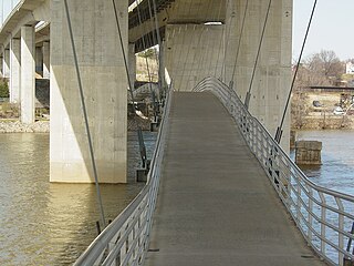
State Route 147 is a primary state highway in the U.S. state of Virginia. The state highway runs 13.13 miles (21.13 km) from U.S. Route 60 in Midlothian east to US 60 in Richmond. In various places, it is known as Huguenot Road, River Road, Cary Street Road and Main Street. SR 147 connects Midlothian with the West End of Richmond via the Huguenot Memorial Bridge across the James River. Within Richmond, the state highway follows Cary Street, a major thoroughfare that connects the city's two major universities, the University of Richmond and Virginia Commonwealth University, with Downtown Richmond.
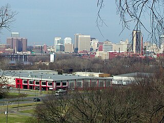
Fulton Hill is a neighborhood located in the East End of Richmond, Virginia. The name is used for the area stretching from Gillies Creek to the Richmond city limits. The Greater Fulton Hill Civic Association includes Fulton Bottom, part of Montrose Heights and part of Rocketts. Fulton Hill is south of Church Hill and Shockoe Bottom, north of Varina, east of the James River, and west of Sandston. The zip code is 23231.

West Hospital is a building on the Medical College of Virginia Campus of Virginia Commonwealth University noted for its Art Deco architecture. It was commissioned by the Federal Works Agency;Public Works Administration and dedicated in 1940. Then known as the "New MCV Hospital", it was the fourth tallest building in Richmond when it opened to national acclaim in 1941, and is still among the tallest.
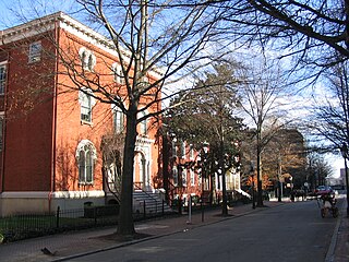
Court End is a neighborhood in Richmond, Virginia, that sits to the north of the Capitol Square and East Broad Street. It developed in the Federal era, after Virginia's capital moved from Williamsburg.
U.S. Route 250 is a part of the U.S. Highway System that runs from Sandusky, Ohio to Richmond, Virginia. In Virginia, the highway runs 166.74 miles (268.34 km) from the West Virginia state line near Hightown east to its eastern terminus at US 360 in Richmond. US 250 is the main east–west highway of Highland County, which is known as Virginia's Little Switzerland; the highway follows the path of the 19th century Staunton and Parkersburg Turnpike. From Staunton east to Richmond, the highway serves as the local complement to Interstate 64 (I-64), roughly following the 18th century Three Notch'd Road through Waynesboro and Charlottesville on its way through the Shenandoah Valley, its crossing of the Blue Ridge Mountains at Rockfish Gap, and the Piedmont. In the Richmond metropolitan area, US 250 is known as Broad Street, a major thoroughfare through the city's West End and downtown areas.
Church Run is a residential neighborhood in Henrico County, Virginia that was built at the beginning of the 1990s. Church Run can be accessed by two entry points: one entry point is off of Church Road, and one is off of Three Chopt Road, between Cox Rd. and John Rolfe Pkwy.
Three Notch'd Road was a colonial-era major east-west route across central Virginia. It is believed to have taken its name from a distinctive marking of three notches cut into trees to blaze the trail. By the 1730s, the trail extended from the vicinity of the fall line of the James River at the future site of Richmond westerly to the Shenandoah Valley, crossing the Blue Ridge Mountains at Jarmans Gap. In modern times, a large portion of U.S. Route 250 in Virginia follows the historic path of the Three Notch'd Road, as does nearby Interstate 64.

Rio Vista is an unincorporated community in the City of Richmond, in the U.S. state of Virginia. Located at intersection of Three Chopt Road and River Road.
Creighton Court is a neighborhood in Richmond, Virginia's East End region. Creighton Court sits on the border between the City of Richmond and eastern Henrico County. The neighborhood is situated directly north of the Oakwood Cemetery and alongside the interchange of Virginia Route 33 and Interstate 64. North 29th Street and Creighton Road serve as the main arteries of the community. Richmond Redevelopment and Housing Authority redeveloped the housing into mixed-income units in 2022.
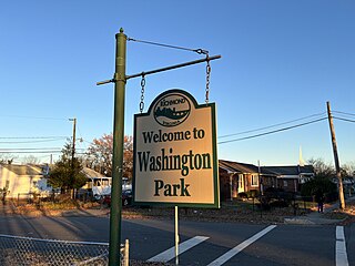
Washington Park is a neighborhood in Richmond, Virginia's North Side. The neighborhood lies west of the Forest Lawn Cemetery and the Richmond Raceway.

Gilpin is a small neighborhood located in Richmond, Virginia and within the boundaries of the North Side of the city limits. Originally part and parcel of the historically Black neighborhood of Jackson Ward, the northern section of that neighborhood was heavily redeveloped with the provision of public housing from the mid-20th century onwards, with the major development taking the name "Gilpin Court". During the same period, a massive expansion of highway building around and through central Richmond saw the Gilpin Court and the rest of the neighborhood essentially cut off from the rest of Jackson Ward.

Jahnke is a neighborhood in Richmond, Virginia located in the Southside region of the city. The neighborhood lies within the city limits. The zip code for the neighborhood is 23225. Jahnke is named after Jahnke Road which is the main road through the neighborhood. The heart of Jahnke is at the intersection of Jahnke Road and German School Road.

Carillon is a neighborhood in the West End of Richmond that is situated in between Virginia State Routes 146 and 161. Adjacent to Maymont and Byrd Park, the middle-class neighborhood is home to the Dogwood Dell Amphitheater. Pump House Drive and Rugby Road are the arteries of the southern tier of the community, while Douglasdale Avenue and South Belmont Drive form the spin of the northern portions of Carillon.
Lockgreen is an upper-class gated community located in Richmond, Virginia's West End. The neighborhood lies within Wilton and is served by Lockgreen Circle. Lockgreen was built as an extension to Windsor Farms's Old Locke subdivision. The zip code for the subdivision is 23226.

Randolph is a historically black middle class neighborhood located within the West End of Richmond, Virginia. The neighborhood is named in honor of Virginia E. Randolph, a former African-American educator in Henrico County, Virginia during the 19th century. The neighborhood is bounded by the Downtown Expressway to the north, Harrison Street to the east, Colorado Avenue to the south, and South Meadow street to the west. Some famous landmarks and places of interest in the neighborhood include Petronius Park, the Randolph Community Center, and just adjacent to the neighborhood, the Hollywood Cemetery.

Colonial Place is a small neighborhood in the West End of Richmond, Virginia.
