Fulton Hill

Last updated
View of Richmond skyline from Powhatan Hill Park Powhatan Hill Park-Richmond VA-Skyline.jpg
View of Richmond skyline from Powhatan Hill Park
Example of Fulton Hill's most characteristic housing form, the bungalow Bungalow-Richmond Virginia-Fulton Hill.jpg
Example of Fulton Hill's most characteristic housing form, the bungalow

Fulton Hill is a neighborhood located in the East End of Richmond, Virginia. [1] The name is used for the area stretching from Gillies Creek to the Richmond city limits. The Greater Fulton Hill Civic Association [2] includes Fulton Bottom, part of Montrose Heights and part of Rocketts. Fulton Hill is south of Church Hill and Shockoe Bottom, north of Varina, east of the James River, and west of Sandston. The zip code is 23231.

Contents

History

This Richmond neighborhood was named for Irish-born James Alexander Fulton, who married Eliza Mayo about 1800 and built a large estate atop current day Powhatan Park. In the 17th century the park was once home to Powhatan Village consisting of twelve dwellings. [3] Tradition holds that Christopher Newport and John Smith first met with Parahunt, Powhatan's son, in May 1607 at this point. [4] In the early 18th century, a ferry was established from a property at the bottom owned by Robert Rocketts to connect the north and south sides of the James River. A neighborhood of low-slung, single-story homes emerged here after the Civil War, and the area was annexed by Richmond from Henrico County in 1905. [5] By the 1960s, the area at the base of the hill bordering Gilies Creek was mostly home to low and middle income African Americans. The housing stock was regarded as rather shabby, and after very severe flood damage in the early 1970s, many residents took Uniform Relocation Assistance and Real Property Acquisition Act (1970) money and relocated elsewhere in the city. [6] Eventually, the entire Fulton Bottom community was completely demolished, marking Richmond's only neighborhood-wide urban renewal slum clearance. [7]

Residents were promised rehabilitation and new construction, but the space once occupied by Fulton lay empty for a full decade before construction of moderate-income housing began. Many regard the failure to replace the razed housing in Fulton as one of the central failures of the city's urban renewal plans.

Fulton Hill Today

The area above the floodplain is an intact urban neighborhood, with a working class character and population. The area is seeing renovation and rehabilitation on the upswing after years of neglect, thanks in large part to dedicated community action to tackle criminal activity, and also to rising property prices in other parts of the city. Fulton Hill's population is primarily African American, but an increasing number of white residents have purchased homes in the neighborhood in recent years, making the neighborhood one of Richmond's most diverse.

Neighborhood businesses, most of which are located along Williamsburg Road, include bank branch, several convenience stores and service stations, a and other stores and restaurants. It also includes longtime community nonprofit The Neighborhood Resource Center [8]

Fulton is home to the east coast hub for Stone Brewing. [9] [10] [11]

Fulton Hill has a large stock of early-20th-century vernacular homes, especially 1- and 1+12-story bungalows, but also including a number of increasingly trendy Sears Catalog homes and several semi-detached Federal rows that date to the earlier years of settlement. [12]

The neighborhood is also home to Richmond National Cemetery, [13] a veteran's cemetery dating to the Civil War with 9,322 interments. An album by the band Alabama Thunderpussy is named "Fulton Hill" after the community.

Related Research Articles

<span class="mw-page-title-main">Richmond, Virginia</span> Capital city of Virginia, United States

Richmond is the capital city of the Commonwealth of Virginia in the United States. Incorporated in 1742, Richmond has been an independent city since 1871. The city's population in the 2020 census was 226,610, up from 204,214 in 2010, making it Virginia's fourth-most populous city. The Richmond metropolitan area, with over 1.3 million residents, is the Commonwealth's third-most populous.

<span class="mw-page-title-main">Urban renewal</span> Land redevelopment in cities

Urban renewal is a program of land redevelopment often used to address urban decay in cities. Urban renewal involves the clearing out of blighted areas in inner cities in favour of new housing, businesses, and other developments.

<span class="mw-page-title-main">Foggy Bottom</span> Neighborhood in Washington, D.C., United States

Foggy Bottom is a neighborhood of Washington, D.C., United States, located in the city's northwest quadrant. Stretching west of the White House towards the Potomac River, the neighborhood is home to numerous federal agencies such as the U.S. Department of State and the Federal Reserve, as well as international institutions such as the World Bank and the International Monetary Fund, while the core of the neighborhood is occupied by George Washington University.

<span class="mw-page-title-main">Oregon Hill</span> United States historic place

Oregon Hill is a historic working-class neighborhood in Richmond, Virginia. Oregon Hill overlooks the James River and Belle Isle, and provides access to Hollywood Cemetery. Due to the neighborhood's proximity to the Monroe Park Campus of Virginia Commonwealth University, the neighborhood is sometimes referred to as a student quarter because of its high college student population.

<span class="mw-page-title-main">History of Richmond, Virginia</span>

The history of Richmond, Virginia, as a modern city, dates to the early 17th century, and is crucial to the development of the colony of Virginia, the American Revolutionary War, and the Civil War. After Reconstruction, Richmond's location at the falls of the James River helped it develop a diversified economy and become a land transportation hub.

The Greater Richmond, Virginia area has many neighborhoods and districts.

<span class="mw-page-title-main">Mattapan</span> Neighborhood of Boston in Suffolk, Massachusetts, United States

Mattapan is a neighborhood in Boston, Massachusetts, United States. Historically and for legal processes a section of Dorchester, Mattapan became a part of Boston when Dorchester was annexed in 1870. Mattapan is the original Native American name for the Dorchester area, possibly meaning "a place to sit." At the 2010 census, it had a population of 36,480, with the majority of its population immigrants.

<span class="mw-page-title-main">East Liberty (Pittsburgh)</span> Neighborhood of Pittsburgh in Allegheny County, Pennsylvania, United States

East Liberty is a neighborhood in Pittsburgh, Pennsylvania's East End. It is bordered by Highland Park, Morningside, Stanton Heights, Garfield, Friendship, Shadyside and Larimer, and is represented on Pittsburgh City Council by Councilwoman Deborah Gross and Rev. Ricky Burgess. One of the most notable features in the East Liberty skyline is the East Liberty Presbyterian Church, which is an area landmark.

<span class="mw-page-title-main">Downtown Richmond, Virginia</span>

Downtown Richmond is the central business district of Richmond, Virginia, United States. It is generally defined as being bound by Belvidere Street to the west, I-95 to the north and east, and the James River to the south. The Fan district borders it to the west, Highland Park to the north, Church Hill to the east, and Manchester to the south.

<span class="mw-page-title-main">Jackson Ward</span> United States historic place

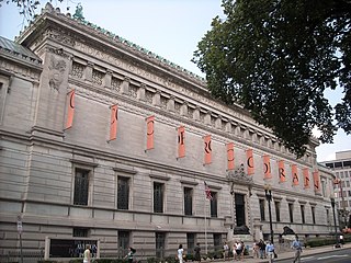
Jackson Ward, previously known as Central Wards, is a historically African-American district in Richmond, Virginia, with a long tradition of African-American businesses. It is located less than a mile from the Virginia State Capitol, sitting to the west of Court End and north of Broad Street. It was listed as a National Historic Landmark District in 1978. "Jackson Ward" was originally the name of the area's political district within the city, or ward, from 1871 to 1905, yet has remained in use long after losing its original meaning.

<span class="mw-page-title-main">Mission Hill, Boston</span> United States historic place

Mission Hill is a 34 square mile, primarily residential neighborhood of Boston, bordered by Roxbury, Jamaica Plain and Fenway-Kenmore and the town of Brookline. The neighborhood has two main streets, namely Tremont Street and Huntington Ave. It is served by several stations on the MBTA's Green Line E branch, as well as Roxbury Crossing station on the Orange Line.

<span class="mw-page-title-main">Lincoln Square, Manhattan</span> Square and neighborhood in New York City

Lincoln Square is the name of both a square and the surrounding neighborhood on the Upper West Side of Manhattan in New York City. Lincoln Square is centered on the intersection of Broadway and Columbus Avenue, between West 65th and 66th streets. The neighborhood is bounded by Columbus and Amsterdam avenues to the east and west, and 66th and 63rd streets to the north and south, respectively. However, the term can be extended to refer to the neighborhood between 59th and 72nd streets. It is bounded by Hell's Kitchen, Riverside South, Central Park, and the Upper West Side proper. The Walt Disney Company’s New York City campus is located here, including ABC, ESPN, Hulu and studios for WABC-TV.

<span class="mw-page-title-main">East End (Richmond, Virginia)</span> Quadrant of Richmond, Virginia

The East End of Richmond, Virginia is the quadrant of the City of Richmond, Virginia, and more loosely the Richmond metropolitan area, east of the downtown.

African-American neighborhoods or black neighborhoods are types of ethnic enclaves found in many cities in the United States. Generally, an African American neighborhood is one where the majority of the people who live there are African American. Some of the earliest African-American neighborhoods were in New Orleans, Mobile, Atlanta, and other cities throughout the American South, as well as in New York City. In 1830, there were 14,000 "Free negroes" living in New York City.

<span class="mw-page-title-main">Chimborazo Park</span>

Chimborazo Park is a park and historic land site in Richmond, Virginia, United States. Created in 1874, the park was the site of Chimborazo Hospital, one of the world's largest military hospitals.

<span class="mw-page-title-main">Northside, Houston</span>

The Northside is a district of Houston, Texas, United States. It is within the Greater Northside Management District.

The following is a timeline of the history of the city of Richmond, Virginia, United States

<span class="mw-page-title-main">Poppleton, Baltimore</span> Neighborhood in Baltimore

Poppleton is a neighborhood in west Baltimore, Maryland. The neighborhood is bounded on the north by West Mulberry Street, on the south by West Baltimore Street, on the west by North Carey Street, and on the east by the Martin Luther King Jr. Boulevard. Previously, Poppleton was construed in a broader sense extending further south to West Pratt Street or Lombard Street, but today this area is commonly described as the separate neighborhood of Hollins Market.

<span class="mw-page-title-main">Sherwood Park (Richmond, Virginia)</span>

Sherwood Park is one of several historical neighborhoods that comprise the area known as Northside in the city of Richmond, Virginia.

<span class="mw-page-title-main">Rocketts Landing</span> Neighborhood in Richmond, Virginia

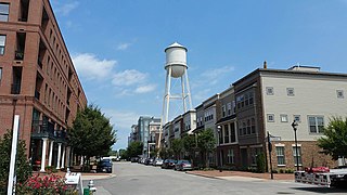
Rockett's Landing is a new urbanist neighborhood in southeastern Richmond, Virginia on the border of Henrico County, Virginia and the north bank of the James River. It was named after Baldwin Rockett, an 18th-century ship's captain born in April 1681 in Exeter, Devon, England.

References

  1. "Richmond Neighborhoods". www.richmondgov.com. Archived from the original on 2012-03-28. Retrieved 2011-09-19.
  2. "GreaterFultonHillCivicAssociation.pdf" (PDF). www.richmondgov.com.
  3. Dabney, Virginius (1976). Richmond: The Story of a City . Garden City, New York: Doubleday & Company, Inc. p.  2. ISBN   0-385-02046-5.
  4. "Re-telling History". Richmond Magazine.
  5. "Valentine Richmond History Center: Settlement to streetcar suburbs". Valentine Richmond History Center. Archived from the original on 2012-07-26. Retrieved 2012-06-01.
  6. "Re-telling History". Richmond Magazine.
  7. Tyler-McGraw, Marie (1994). At the falls: Richmond, Virginia, and its people. Chapel Hill: University of North Carolina Press. pp. 302–304. ISBN   0-8078-4476-4.
  8. "Indelible Roots: Historic Fulton and Urban Renewal". WCVE/The Community Idea Stations. Retrieved July 21, 2016.
  9. "City makes pricey promises to land Stone Brewing". BizSense. Retrieved October 9, 2014.
  10. "Stone Brewing bistro plans inch forward; hotel possible". BizSense. Retrieved September 1, 2016.
  11. "Stone Brewing ramps up Fulton production capacity". BizSense. Retrieved December 8, 2017.
  12. Childers, Doug. "Greater Fulton: A sprawling neighborhood that thrives on diversity" (PDF). Richmond Times-Dispatch. Retrieved April 6, 2012.
  13. "Richmond National Cemetery". United States Department of Veterans Affairs.

37°30′56″N77°23′54″W / 37.51556°N 77.39833°W / 37.51556; -77.39833