
The East End of Richmond, Virginia is the quadrant of the City of Richmond, Virginia, and more loosely the Richmond metropolitan area, east of the downtown.
The East End of Richmond, Virginia is the quadrant of the City of Richmond, Virginia, and more loosely the Richmond metropolitan area, east of the downtown.
Within the city, and in Henrico County, East End is roughly defined as including the area of Richmond north of the James River and east/northeast of the former Virginia Central Railroad - Chesapeake and Ohio Railway line (now owned by CSX Transportation and operated by the Buckingham Branch Railroad) which originated at Main Street Station, and south and west of I-295.
Within the city, this includes neighborhoods such as Church Hill, Fairmount, Union Hill, Fulton, Powhatan Hill, Fulton Hill, Montrose Heights, Fairfield Court, Creighton Court, Whitcomb Court, Mosby Court, Eastview, Brauers, Peter Paul, Woodville, North Church Hill, Chimborazo and Oakwood.
The terminology "East End" also broadly includes much of eastern Henrico County as a portion the Richmond Metropolitan area. [1] Communities outside the city limits in this area include the census-designated places of Highland Springs, Montrose, Sandston, and Varina.
A portion of Hanover County, primarily in the Mechanicsville area also meets the above geographic description, and may be considered by some to be part of the East End of Metropolitan Richmond, though is equally considered outside of the quadrant system, due to its separation from the city by the Chickahominy River and swamp. [1]
In the era just before and as European settlement began at the turn of the 17th century, near Powhatan Hill, a place known as "Powhatan" which was the village or "town" that Wahunsunacock (who has become better-known as the Chief Powhatan) came from was located. An early capital of the Powhatan Confederacy, "Powhatan" was also the name used by the natives to refer to the James River).[ citation needed ]
The East End contains a number of notable cemeteries, including the Confederate Cemetery of Oakwood, the historic African-American Evergreen Cemetery, and the Richmond National Cemetery. The East End is also home to the famous St. John's Church, where Patrick Henry delivered his "Give Me Liberty" speech.
As of the 2020s, the area is a target for urban renewal and investment. [2]

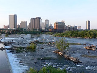
Richmond is the capital city of the Commonwealth of Virginia in the United States. Incorporated in 1742, Richmond has been an independent city since 1871. The city's population in the 2020 census was 226,610, up from 204,214 in 2010, making it Virginia's fourth-most populous city. The Richmond metropolitan area, with 1,260,029 people, is the Commonwealth's third-most populous.

Powhatan County is a county located in the Commonwealth of Virginia. As of the 2020 census, the population was 30,033. Its county seat is Powhatan.

Goochland County is a county located in the Piedmont of the Commonwealth of Virginia. Its southern border is formed by the James River. As of the 2020 census, the population was 24,727. Its county seat is Goochland.
The Greater Richmond Region, the Richmond metropolitan area or Central Virginia, is a region and metropolitan area in the U.S. state of Virginia, centered on Richmond. The U.S. Office of Management and Budget (OMB) defines the area as the Richmond, VA Metropolitan Statistical Area, a Metropolitan Statistical Area (MSA) used by the U.S. Census Bureau and other entities. The OMB defines the area as comprising 17 county-level jurisdictions, including the independent cities of Richmond, Petersburg, Hopewell, and Colonial Heights. As of 2020, it had a population of 1,314,434, making it the 44th largest MSA in the country.

The West End is a part of Richmond, Virginia. Definitions of the bounds of the West End vary, it may include only the western part of the city of Richmond or extend as far as western Henrico County. As there is no one municipal organization that represents this specific region, the boundaries are loosely defined as being north of the James River, west of I-195, and south of Broad Street. Historically, the Richmond neighborhoods of the Fan and the Museum District were a part of the West End. A primary conduit through the West End is Interstate 64.

Broad Street is a 15-mile-long (24 km) road located in the independent city of Richmond, Virginia, and adjacent Henrico County. Broad Street is significant to Richmond due to the many commercial establishments that have been built along it throughout Richmond's history. From downtown through miles into the suburbs, the street is largely dedicated to retailing and offices, including regional and neighborhood shopping centers and malls.

The history of Richmond, Virginia, as a modern city, dates to the early 17th century, and is crucial to the development of the colony of Virginia, the American Revolutionary War, and the Civil War. After Reconstruction, Richmond's location at the falls of the James River helped it develop a diversified economy and become a land transportation hub.
The Greater Richmond, Virginia area has many neighborhoods and districts.
The Southside of Richmond is an area of the Metropolitan Statistical Area surrounding Richmond, Virginia. It generally includes all portions of the City of Richmond that lie south of the James River, and includes all of the former city of Manchester. Depending on context, the term "Southside of Richmond" can include some northern areas of adjacent Chesterfield County, Virginia in the Richmond-Petersburg region. With minor exceptions near Bon Air, VA, the Chippenham Parkway forms the border between Chesterfield County and the City of Richmond portions of Southside, with some news agencies using the term "South Richmond" to refer to the locations in Southside located in the city proper.

State Route 288 is a primary state highway in the U.S. state of Virginia. It is a freeway-standard partial beltway around the southwest side of the Richmond, Virginia metropolitan area in portions of Goochland, Powhatan, and Chesterfield counties. SR 288 was officially dedicated as the World War II Veterans Memorial Highway in 2004.

Transportation in Richmond, Virginia and its immediate surroundings include land, sea and air modes. This article includes the independent city and portions of the contiguous counties of Henrico and Chesterfield. While almost all of Henrico County would be considered part of the Richmond area, southern and eastern portions of Chesterfield adjoin the three smaller independent cities of Petersburg, Hopewell, and Colonial Heights, collectively commonly called the Tri-Cities area. A largely rural section of southwestern Chesterfield may be considered not a portion of either suburban area.

Richmond National Cemetery is a United States National Cemetery three miles (4.8 km) east of Richmond in Henrico County, Virginia. Administered by the United States Department of Veterans Affairs, it encompasses 9.7 acres (3.9 ha), and as of 2021 had more than 11,000 interments. It is closed to new interments. Richmond National Cemetery was listed on the National Register of Historic Places in 1995.
Fulton Hill is a neighborhood located in the East End of Richmond, Virginia. The name is used for the area stretching from Gillies Creek to the Richmond city limits. The Greater Fulton Hill Civic Association includes Fulton Bottom, part of Montrose Heights and part of Rocketts. Fulton Hill is south of Church Hill and Shockoe Bottom, north of Varina, east of the James River, and west of Sandston. The zip code is 23231.

U.S. Route 60 (US 60) in the Commonwealth of Virginia runs 303 miles (488 km) west to east through the central part of the state, generally close to and paralleling the Interstate 64 corridor, except for the crossing of the Blue Ridge Mountains, and in the South Hampton Roads area.

Oakwood Cemetery is a large, city-owned burial ground in the East End of Richmond, Virginia. It holds over 48,000 graves, including many soldiers from the Civil War.
The following is a timeline of the history of the city of Richmond, Virginia, United States
Creighton Court is a neighborhood in Richmond, Virginia's East End region. Creighton Court sits on the border between the City of Richmond and eastern Henrico County. The neighborhood is situated directly north of the Oakwood Cemetery and alongside the interchange of Virginia Route 33 and Interstate 64. North 29th Street and Creighton Road serve as the main arteries of the community.
Randolph is a historically black middle class neighborhood located within the West End of Richmond, Virginia. The neighborhood is named in honor of Virginia E. Randolph, a former African-American educator in Henrico County, Virginia during the 19th century. The neighborhood is bounded by the Downtown Expressway to the north, Harrison Street to the east, Colorado Avenue to the south, and South Meadow street to the west. Some famous landmarks and places of interest in the neighborhood include Petronius Park, the Randolph Community Center, and just adjacent to the neighborhood, the Hollywood Cemetery.
37°32′8″N77°24′32″W / 37.53556°N 77.40889°W
| | This City of Richmond, Virginia state location article is a stub. You can help Wikipedia by expanding it. For articles relating to the County of Richmond, use Template:RichmondCountyVA-geo-stub |