Mechanicsville is an unincorporated area and census-designated place (CDP) in Hanover County, Virginia, United States. The population was 39,482 during the 2020 census, up from 36,348 in the 2010 census.

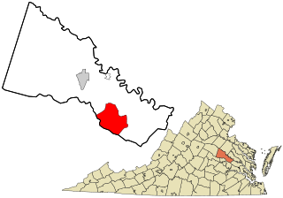
Luray is the county seat of Page County, Virginia, United States, in the Shenandoah Valley in the northern part of the Commonwealth. The population was 4,895 at the 2010 census.

Byrd Park, also known as William Byrd Park, is a public park located in Richmond, Virginia, United States, north of the James River and adjacent to Maymont. The 200-acre (0.81 km2) park includes a mile-long trail with exercise stops, monuments, an amphitheatre, and three small lakes: Shields, Swan, and Boat Lake. Boat Lake has a lighted fountain at its center. Visitors can rent pedal boats there in season. The park includes tennis courts, Little League baseball fields, and a children's playground. The historic round house and Poplar Vale Cemetery are also located in the park. It is named after William Byrd II, whose family owned much of the area when Richmond was founded in 1737. The park was listed on the National Register of Historic Places in 2016.

Oregon Hill is a historic working-class neighborhood in Richmond, Virginia. Oregon Hill overlooks the James River and Belle Isle, and provides access to Hollywood Cemetery. Due to the neighborhood's proximity to the Monroe Park Campus of Virginia Commonwealth University, the neighborhood is sometimes referred to as a student quarter because of its high college student population.

Ginter Park is a suburban neighborhood of Richmond, Virginia built on land owned and developed by Lewis Ginter. The neighborhood's first well known resident was newspaperman Joseph Bryan, who lived in Laburnum, first built in 1883 and later rebuilt. In 1895, many acres of land north of Richmond were purchased by Ginter in order to develop into neighborhoods. Ginter Park and other neighborhoods were developed from this initial land purchase. In Ginter Park are Union Presbyterian Seminary and as well as Pollard Park.

The White House of the Confederacy is a historic house located in the Court End neighborhood of Richmond, Virginia. Built in 1818, it was the main executive residence of the sole President of the Confederate States of America, Jefferson Davis, from August 1861 until April 1865. It was viewed as the Confederate States counterpart to the White House in Washington, D.C. It currently sits on the campus of Virginia Commonwealth University.
The Greater Richmond, Virginia area has many neighborhoods and districts.

The James River and Kanawha Canal was a partially built canal in Virginia intended to facilitate shipments of passengers and freight by water between the western counties of Virginia and the coast. Ultimately its towpath became the roadbed for a rail line following the same course.

The Southside of Richmond is an area of the Metropolitan Statistical Area surrounding Richmond, Virginia. It generally includes all portions of the City of Richmond that lie south of the James River, and includes all of the former city of Manchester. Depending on context, the term "Southside of Richmond" can include some northern areas of adjacent Chesterfield County, Virginia in the Richmond-Petersburg region. With minor exceptions near Bon Air, VA, the Chippenham Parkway forms the border between Chesterfield County and the City of Richmond portions of Southside, with some news agencies using the term "South Richmond" to refer to the locations in Southside located in the city proper.
Malvern Hill stands on the north bank of the James River in Henrico County, Virginia, USA, about eighteen miles southeast of Richmond. On 1 July 1862, it was the scene of the Battle of Malvern Hill, one of the Seven Days Battles of the American Civil War.

Jackson Ward, previously known as Central Wards, is a historically African-American district in Richmond, Virginia, with a long tradition of African-American businesses. It is located less than a mile from the Virginia State Capitol, sitting to the west of Court End and north of Broad Street. It was listed as a National Historic Landmark District in 1978. "Jackson Ward" was originally the name of the area's political district within the city, or ward, from 1871 to 1905, yet has remained in use long after losing its original meaning.
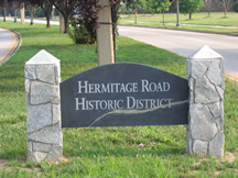
Hermitage Road Historic District (HRHD) is a Northside neighborhood in the independent city of Richmond, Virginia. The district is a Richmond Old and Historic District, as well as being listed on the Virginia Landmarks Register and the National Register of Historic Places.

Shockoe Bottom historically known as Shockoe Valley, is an area in Richmond, Virginia, just east of downtown, along the James River. Located between Shockoe Hill and Church Hill, Shockoe Bottom contains much of the land included in Colonel William Mayo's 1737 plan of Richmond, making it one of the city's oldest neighborhoods.

Forest Hill Park, known for its "Stone house" called Boscobel, is a historic 105-acre (0.4 km2) urban park in Richmond, Virginia. Starting as a private property, the park has had several owners and uses before its present one, the City of Richmond.

Barton Heights is a streetcar suburb neighborhood and former town in the Northside area of Richmond, Virginia. The area was primarily developed between 1890 and the 1920s.

The Chestnut Hill–Plateau Historic District is a historic area in the Highland Park neighborhood of Richmond, Virginia. It is also known as 'Highland Park Southern Tip' on city neighborhood maps.

Highland Park–Overlee Knolls, also known as Fostoria, is a national historic district located in Arlington County, Virginia. It is directly east of the Virginia Heights Historic District. It contains 681 contributing buildings, 3 contributing sites, and 1 contributing structure in a residential neighborhood in North Arlington. The first subdivision was platted in 1890 and known as Fostoria.

Libby Hill is a small neighborhood in Richmond, Virginia. Libby Hill is located on the southeastern spur of Church Hill, overlooking the James River and the Lucky Strike building. It is known for Libby Hill Park and "The View that Named Richmond". The Libby Hill neighborhood is entirely within the St. John's Church Historic District.


