
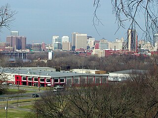
Petersburg is an independent city in the Commonwealth of Virginia in the United States. As of the 2020 census, the population was 33,458 with a majority black American. The Bureau of Economic Analysis combines Petersburg with Dinwiddie County for statistical purposes. The city is 21 miles (34 km) south of the commonwealth (state) capital city of Richmond.

Manchester is a former independent city in Virginia in the United States. Prior to receiving independent status, it served as the county seat of Chesterfield County, between 1870 and 1876. Today, it is a part of the city of Richmond, Virginia.
The Greater Richmond, Virginia area has many neighborhoods and districts.
The Northside is an area composed of northern Richmond, Virginia and some parts of Henrico County, Virginia.

Downtown Richmond is the central business district of Richmond, Virginia, United States. It is generally defined as being bound by Belvidere Street to the west, I-95 to the north and east, and the James River to the south. The Fan district borders it to the west, Highland Park to the north, Church Hill to the east, and Manchester to the south.
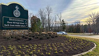
Brandermill is a major suburban residential and commercial development in the Southside of Richmond, Virginia. It is located near Midlothian, Virginia at the southern terminus of the Powhite Parkway and is centered on the Swift Creek Reservoir. The Census Bureau defines it as a Census-designated place (CDP), with a population of 13,173 as of the most updated estimate done in 2010.
Fulton Hill is a neighborhood located in the East End of Richmond, Virginia. The name is used for the area stretching from Gillies Creek to the Richmond city limits. The Greater Fulton Hill Civic Association includes Fulton Bottom, part of Montrose Heights and part of Rocketts. Fulton Hill is south of Church Hill and Shockoe Bottom, north of Varina, east of the James River, and west of Sandston. The zip code is 23231.

U.S. Route 1 (US 1) is a major north–south U.S. Route that serves the East Coast of the United States. In the U.S. state of Virginia, US 1 runs north–south through South Hill, Petersburg, Richmond, Fredericksburg, and Alexandria on its way from North Carolina to the 14th Street bridges into the District of Columbia. It is completely paralleled by Interstate Highways in Virginia—Interstate 85 (I-85) south of Petersburg, I-95 north to Alexandria, and I-395 into the District of Columbia—and now serves mainly local traffic. At its north end, on the approach to the 14th Street bridges, US 1 is concurrent with I-395; the rest of US 1 is on surface roads.
The Iron Triangle, sometimes known as Central Richmond, is a neighborhood in Richmond, California. It is a largely residential area but includes the downtown Richmond business district along Macdonald Avenue. Commercial areas on Cutting Boulevard and near Interstate 580 are also in the neighborhood if the more extensive of two possible definitions of its area is used.
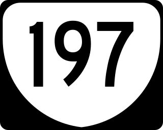
State Route 197 is a primary state highway in the U.S. state of Virginia. The state highway runs 3.60 miles (5.79 km) from SR 147 in Richmond east to U.S. Route 1 and US 301 in Richmond.
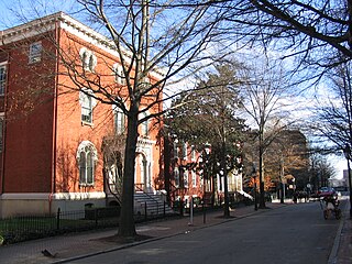
Court End is a neighborhood in Richmond, Virginia, that sits to the north of the Capitol Square and East Broad Street. It developed in the Federal era, after Virginia's capital moved from Williamsburg.

The Richmond Arts and Culture District stretches from the Institute for Contemporary Art on West Broad to the Virginia State Capitol and spans the Monroe Ward and Jackson Ward neighborhoods. The Arts District was designed to be the center of artistic, cultural, civic, and commercial activity. This district has worked to promote economic prosperity in this area of Richmond and create areas for art galleries and artist living spaces. This inclusive district offers a variety of experiences for all visitors and locals. The Arts District features and supports the history of the Jackson Ward neighborhood, the business activity along West Broad Street, the wide range of downtown art galleries, and eclectic dining and shopping experiences. The District is the first of its kind in the city of Richmond but state law allows there to be more than Arts District in each city.
The Biotech and MCV District is the community that surrounds the MCV Campus of Virginia Commonwealth University in Downtown Richmond, Virginia.

Pine Camp is a neighborhood in Richmond, Virginia's North Side. The area is heavily forested, and houses the Pine Camp Community Center, one of the largest recreational centers in Northern Richmond. The neighborhood is north of John Marshall High School and west of the Forest Lawn Cemetery.
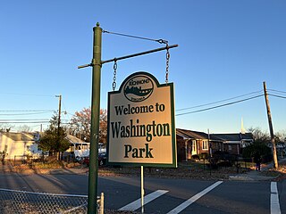
Washington Park is a neighborhood in Richmond, Virginia's North Side. The neighborhood lies west of the Forest Lawn Cemetery and the Richmond Raceway.

Carver is a neighborhood near the Virginia Commonwealth University campus in Richmond, Virginia, and straddles alongside the border between Downtown Richmond and North Side. The neighborhood is in the process of gentrification and is heavily inhabited with students attending Virginia Commonwealth and Virginia Union universities due to the two school's proximities to the neighborhood.
Gilpin is a small neighborhood located in Richmond, Virginia and within the boundaries of the North Side of the city limits. Originally part and parcel of the historically Black neighborhood of Jackson Ward, the northern section of that neighborhood was heavily redeveloped with the provision of public housing from the mid-20th century onwards, with the major development taking the name "Gilpin Court". During the same period, a massive expansion of highway building around and through central Richmond saw the Gilpin Court and the rest of the neighborhood essentially cut off from the rest of Jackson Ward.
Randolph is a historically black middle class neighborhood located within the West End of Richmond, Virginia. The neighborhood is named in honor of Virginia E. Randolph, a former African-American educator in Henrico County, Virginia during the 19th century. The neighborhood is bounded by the Downtown Expressway to the north, Harrison Street to the east, Colorado Avenue to the south, and South Meadow street to the west. Some famous landmarks and places of interest in the neighborhood include Petronius Park, the Randolph Community Center, and just adjacent to the neighborhood, the Hollywood Cemetery.

Brookfield Plantation was an about 2,000 acre plantation in Henrico County, Virginia in the late 18th and 19th-centuries. It was first owned by the Prosser family and it is where Gabriel Prosser planned Gabriel's Rebellion of 1800. It is one of several lost historical buildings of the county, and it is near Bon Air, Virginia and Bryan Park in Richmond, Virginia.
