Richmond is the capital city of the Commonwealth of Virginia in the United States. It is the center of the Richmond Metropolitan Statistical Area (MSA) and the Greater Richmond Region. Richmond was incorporated in 1742 and has been an independent city since 1871. As of the 2010 census, the city's population was 204,214; in 2020, the population had grown to 226,610, making Richmond the fourth-most populous city in Virginia. The Richmond Metropolitan Area has a population of 1,260,029, the third-most populous metro in the state.
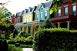
Church Hill, also known as the St. John's Church Historic District, is an Old and Historic District in Richmond, Virginia. This district encompasses the original land plat of the city of Richmond. Church Hill is the eastern terminus of Broad Street, a major east-west thoroughfare in the Richmond metropolitan area. The name Church Hill is often used to describe both the specific historic district and the larger general area in the East End encompassing other neighborhoods such as Union Hill, Chimborazo, Fairmount, Peter Paul, Woodville, etc.

The Fairfax District is a neighborhood in the Central region of Los Angeles, California.

The Fan is a district of Richmond, Virginia, so named because of the "fan" shape of the array of streets that extend west from Belvidere Street, on the eastern edge of Monroe Park, westward to Arthur Ashe Boulevard. However, the streets rapidly resemble a grid after they go through what is now Virginia Commonwealth University. The Fan is one of the easterly points of the city's West End section, and is bordered to the north by Broad Street and to the south by VA 195, although the Fan District Association considers the southern border to be the properties abutting the south side of Main Street. The western side is sometimes called the Upper Fan and the eastern side the Lower Fan, though confusingly the Uptown district is located near VCU in the Lower Fan. Many cafes and locally owned restaurants are located here, as well as historic Monument Avenue, a boulevard featuring enormous equine statuary of Civil War Confederate generals and a statue of tennis icon Arthur Ashe. Development of the Fan district was strongly influenced by the City Beautiful movement of the late 19th century.

Clarendon is an urbanized, upper-class neighborhood in Arlington County, Virginia, located between the Rosslyn area and the Ballston area. It was named after Edward Hyde, 1st Earl of Clarendon, a leading statesman and historian of the English Civil War. The main thoroughfares are Wilson Boulevard and Clarendon Boulevard.
This article is about the many neighborhoods and districts in the Greater Richmond, Virginia area. Note that this article is an attempt to be inclusive of the broader definitions of the areas which are often considered part of the Greater Richmond Region, based on their urban or suburban character and nature, rather than by strictly political boundaries.

The Virginia Historical Society (VHS), founded in 1831 as the Virginia Historical and Philosophical Society and headquartered in Richmond, Virginia, is a major repository, research, and teaching center for Virginia history. It is a private, non-profit organization, supported almost entirely by private contributions. In 2004, it was designated the official state historical society of the Commonwealth of Virginia.
Mid-Wilshire is a neighborhood in the central region of Los Angeles, California. It is known for the Los Angeles County Museum of Art, the Petersen Automotive Museum, and the Miracle Mile shopping district.
Arthur Ashe Boulevard is a historic street in the near the West End of Richmond, Virginia, providing access to Byrd Park. It serves as the border between the Carytown/Museum District to the west and the Fan district to the east. Attempts were made to rename the street after Arthur Ashe, a tennis star and social activist who was born and grew up in Richmond, but previous attempts failed until February 2019 when Richmond City Council voted in favor of changing the name to Arthur Ashe Boulevard. Near the south end is Richmond's Boulevard Bridge across the James River. Arthur Ashe Boulevard intersects with main arteries Cary Street, Main Street, Monument Avenue, Broad Street, Leigh Street, and Interstate 64/95, and terminates at Hermitage Road. The Diamond is located on Arthur Ashe Boulevard. The intersection of Arthur Ashe Boulevard and Monument Avenue featured a statue of Stonewall Jackson.

Civic Center, Denver is a neighborhood in Denver, Colorado, United States. The northern part of the neighborhood overlaps partially with the Denver Civic Center, an area of parks and civic buildings.

Jackson Ward is a historically African-American district in Richmond, Virginia with a long tradition of African-American businesses. It is located less than a mile from the Virginia State Capitol, sitting to the west of Court End and north of Broad Street. It was listed as a National Historic Landmark District in 1978. "Jackson Ward" was originally the name of the area's political district within the city, or ward, from 1871 to 1905, yet has remained in use long after losing its original meaning.
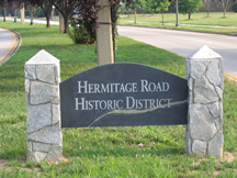
Hermitage Road Historic District (HRHD) is a Northside neighborhood in the independent city of Richmond, Virginia. The district is a Richmond Old and Historic District, as well as being listed on the Virginia Landmarks Register and the National Register of Historic Places.

Carytown is an urban retail district in Richmond, Virginia; it is along Cary Street at the southern end of the Museum District. Located west of the historic Fan District, Carytown has an eclectic flavor and includes more than 230 shops, restaurants, and offices. The Byrd Theatre, a restored movie palace that has operated continuously since 1928, is located in this district.

Montrose is a neighborhood located in west-central Houston, Texas, United States. Montrose is a 7.5-square-mile (19 km2) area roughly bounded by Interstate 69/U.S. Highway 59 to the south, Allen Parkway to the north, South Shepherd Drive to the west, and Taft to Fairview to Bagby to Highway 59 to Main to the east. The area is also referred to as Neartown or Neartown / Montrose.

Originally a trolley car suburb in the years just before the dawn of the 20th century, the Fairmount neighborhood in Church Hill, Richmond, Virginia, is located just north of Union Hill. Much of the neighborhood was developed from the 1890s to the 1920s, and its buildings largely reflect Queen Anne, Italianate, and 1920s bungalow architecture. What is likely the oldest remaining residence, a frame house, probably dates from before 1870. A notable property in the Fairmount neighborhood is the Fairmount School. Annexed from Henrico County in 1906, Fairmount was first incorporated as an independent town on March 10, 1902.

Shockoe Bottom is an area in Richmond, Virginia, just east of downtown, along the James River. Located between Shockoe Hill and Church Hill, Shockoe Bottom contains much of the land included in Colonel William Mayo's 1737 plan of Richmond, making it one of the city's oldest neighborhoods.
Standard Drug Company was a drugstore chain based in Richmond, Virginia. It was founded in 1919 by Samuel and Leo Rosenthal, who were graduates of the MCV School of Pharmacy. The first store opened on Main Street in Downtown Richmond as a pharmacy only. In 1921 the Rosenthals acquired a large building at the corner of First and Broad streets that became the anchor store to the first discount drug chain in America. It thrived for decades, expanding throughout Virginia into Washington, D.C., and its Maryland suburbs.
The Richmond Arts and Culture District stretches from the Institute for Contemporary Art on West Broad to the Virginia State Capitol and spans the Monroe Ward and Jackson Ward neighborhoods. The Arts District was designed to be the center of artistic, cultural, civic, and commercial activity. This district has worked to promote economic prosperity in this area of Richmond and create areas for art galleries and artist living spaces. This inclusive district offers a variety of experiences for all visitors and locals. The Arts District features and supports the history of the Jackson Ward neighborhood, the business activity along West Broad Street, the wide range of downtown art galleries, and eclectic dining and shopping experiences. The District is the first of its kind in the city of Richmond but state law allows there to be more than Arts District in each city.

Cary Street Park and Shop Center, also known as the Cary Court Shopping Center, is a historic shopping center developed by the C.F. Sauer family in the Carytown district of Richmond, Virginia. It was built in 1938 in the Art Deco style. Two rectangular wings to the west and east were completed in 1949 and 1951. The structure is essentially a one-story structure in the shape of an elongated "U" and constructed of brick, granite, limestone and marble veneer. It features a prominent parking area, an uninterrupted string of large modern aluminum and glass doors and commercial storefront windows, a stepped limestone parapet, curved windows, and a low, projecting stucco canopy.

The Scott's Addition Historic District is a national historic district located in Richmond, Virginia.