Manchester, Richmond, Virginia

Last updated

Manchester
RichmondNSEW.png
Manchester as situated in present-day Richmond
CountryUnited States of America
StateVirginia
CountyChesterfield (to 1874); Independent (1874–1910)
Incorporated (town)1769
Incorporated (city)1874
Merged with Richmond1910
Named for Manchester, England

Manchester is a former independent city in Virginia in the United States. Prior to receiving independent status, it served as the county seat of Chesterfield County, between 1870 and 1876. Today, it is a part of the city of Richmond, Virginia.

Contents

Originally known as Manastoh and later Rocky Ridge, it was located on the south bank of the James River at the fall line opposite the state capital city of Richmond, on the north side of the river. Manchester was an active port city, and was a port of entry for slave ships principally in the 18th century. The port shipped out tobacco and coal which was transported 13 miles overland from the Midlothian-area mines on the Midlothian Turnpike, first paved toll road in Virginia in 1807, and the Chesterfield Railroad, the state's first in 1831. Manchester became an incorporated town in 1769 and an independent city in 1874. In 1910, it merged by mutual agreement with the larger state capital City of Richmond, achieving another "first" as the earliest of Virginia's independent cities to lose its identity.

Today, "Old Manchester" is considered a neighborhood of Richmond. Many vestiges of its past are clearly visible, notably the courthouse, the Hull Street business district, a number of historic houses, and several former railroad and street railway buildings. As part of the community's African American heritage, a "slave trail" traces the route into the downtown area from where the slave ships docked along the river. Interstate 95, and four other major highways, U.S. Routes 1, 60, 301 and 360 all cross the James River and enter downtown Richmond from Manchester.

Rocky Ridge, seaport, mills, and railroads

As a result of the Second Anglo-Powhatan War, in 1645 the Virginia Colony's House of Burgesses provided for Fort Charles to be built and garrisoned at the Falls of the James, to protect the frontier. After two years, Fort Charles was relocated to the south side, to the high ground above the later Atlantic Coast Line Railroad Bridge, on a tract owned by Capt. Thomas Harris. This land was then still known by its native name, Manastoh, but was thereafter renamed Rocky Ridge by the English. [1] Rocky Ridge in 1769 became an incorporated town on Chesterfield County, with the name of Manchester.

Manchester grew to become a major seaport in the 17th through 19th centuries, as did its neighbor Richmond on the north bank of the river. Both were located at the head of navigation of the tidal James River at the geological fall line. Above that point, the river consists of seven miles of rapids before becoming more navigable again west of Richmond, although much shallower.

Before the American Revolutionary War, tobacco industries made the town their home. It was also known as a major slave market. Manchester was commercially successful primarily due to its agricultural mills and docks.

From northwestern Chesterfield County, coal from the Midlothian area 13 miles west was transported to the docks at Manchester, first on the Manchester Turnpike, a toll road and Virginia's first graveled road of any length completed in 1807. Later, beginning in 1831, the congested turnpike was supplemented by the gravity and mule-powered Chesterfield Railroad, the first railroad in Virginia, partially engineered and funded by the Virginia Board of Public Works. For its final several miles, the line followed present-day Maury Street, which was the southern border of Manchester for many years. It crossed over the steam-powered Richmond and Petersburg Railroad (later Atlantic Coast Line Railroad) tracks (now abandoned) on a high trestle between what is now Clopton Street and Jefferson Davis Highway. When the new Richmond and Danville Railroad (R&D) was completed between Manchester and Coalfield Station (now Midlothian) in 1851, the older Chesterfield Railroad was unable to compete and portions were acquired by the R&D, with the remainder dismantled before the Civil War took place.

County seat of Chesterfield County

Manchester Courthouse
Manchester Courthouse.JPG
Location920 Hull St., Richmond, Virginia
Coordinates 37°31′16″N77°26′28″W / 37.52111°N 77.44111°W / 37.52111; -77.44111
Arealess than one acre
Built1871
Architect Albert L. West
Architectural styleColonial Revival
NRHP reference No. 98000450 [2]
VLR No.127-5010
Significant dates
Added to NRHPMay 8, 1998
Designated VLRDecember 3, 1997 [3]

During Reconstruction, Manchester was briefly the county seat of Chesterfield County, from 1870 until 1876. County voters approved the move from Chesterfield Court House, Virginia, and the cornerstone of the new courthouse was laid on March 31, 1871. [4] It was designed by Richmond-based architect A.L. West. The former courthouse complex on Hull Street is now the Manchester Division of the Richmond City courts.

Manchester became an independent city in 1874, and was therefore no longer technically located in Chesterfield County. In the election that year, county voters were again asked if they wished to relocate the county seat elsewhere, but rejected a move following a heated campaign, by a vote of 1,442 to 388. However, when the question of a move came up once again on the 1876 ballot, voters approved, 1290 to 772, a return to Chesterfield Courthouse, which became effective on July 1 that year. [5]


Manchester agrees to consolidate with Richmond

For over 250 years, the James River divided Richmond on the north bank from its sister, Manchester, located on the south bank. A major issue for Manchester and Richmond residents in the 19th and early 20th century were the toll ferries and toll bridges over the James River. The latter were subject to frequent destruction by ice floes and flooding on the river.

There were periodic talks and negotiations for over 35 years between the cities before, in 1910, Manchester agreed to a political consolidation with the much larger independent City of Richmond. Richmond's better-known name was used for both areas as it contained the location of Virginia's state capital. Two of the key features of the consolidation agreement were requirements that a free bridge across the James River be built and that the separate courthouse in Manchester be maintained indefinitely. Instead of being a barrier between neighboring cities, under the consolidation, the James River became the centerpiece of the expanded Richmond.

Today, Manchester is recognized as a historic district in state and national registers. Although Manchester is extinct as an independent city, vestiges can be found in the Manchester Bridge, Manchester Slave Trail, and the Manchester Courthouse. Manchester and other areas of the City of Richmond south of the James River are locally referred to as "South Richmond", "South Side Richmond" or simply "South Side."

Manchester as neighborhood: industry

Manchester Industrial Historic District
Hull Street Station Richmond Va.JPG
LocationRoughly bounded by Perry St., James R., Mayo's Bridge, Maury St., and 10th St., Richmond, Virginia
Coordinates 37°31′35″N77°26′13″W / 37.52639°N 77.43694°W / 37.52639; -77.43694
Area110 acres (45 ha)
ArchitectSmith, I.J., and Co.; Concrete Steel Engineering Co.
Architectural styleArt Deco, Beaux Arts, et al.
NRHP reference No. 00000886 [2]
VLR No.127-0457
Significant dates
Added to NRHPAugust 2, 2000
Designated VLRMarch 15, 2000, March 17, 2004, September 22, 2011 [3]

Though part of the city of Richmond, Manchester's industrial presence continued to flourish in the 20th century. Manchester was serviced by Hull Street Station on the Southern Railway, built in 1901, the only major urban depot on the southern side of the James River. The skyline is dominated by the Southern States silos, the tallest structures south of the River. Cooperative

Manchester as neighborhood: Residential and Commercial

Manchester Residential and Commercial Historic District
Mechanics and Merchants Bank.jpg
LocationRoughly bounded by 9th St., McDonough St., Cowardin Ave., and Stockton St., Richmond, Virginia
Coordinates 37°31′18″N77°26′49″W / 37.52167°N 77.44694°W / 37.52167; -77.44694
Architectural styleColonial Georgian, Art Deco, Greek Revival
NRHP reference No. 06000976 [2]  (original)
100003308  (increase)
VLR No.127-0859
Significant dates
Added to NRHPNovember 1, 2006
Boundary increaseDecember 20, 2018
Designated VLRMarch 14, 2001, June 17, 2005, October 11, 2005, September 6, 2006 [3]

The Manchester Residential and Commercial Historic District is located in the city of Richmond, Virginia, on the south side of the James River. It is connected to the financial district in Richmond by the Lee, Mayo and Manchester bridges. In the 1800s, Manchester along with Richmond, had become a major port and commercial center serving the eastern seaboard and beyond. Manchester was granted city status in 1874 and became the seat of Chesterfield County. In 1910, the city of Richmond annexed Manchester. [6]

See also

Related Research Articles

<span class="mw-page-title-main">Chesterfield County, Virginia</span> County in Virginia, United States

Chesterfield County is located just south of Richmond in the Commonwealth of Virginia. The county's borders are primarily defined by the James River to the north and the Appomattox River to the south. Its county seat is Chesterfield Court House.

<span class="mw-page-title-main">Bon Air, Virginia</span> Census-designated place in Virginia, United States

Bon Air is a census-designated place (CDP) in Chesterfield County, Virginia, United States. The population was 18,022 at the 2020 census. The community is considered a suburb of the independent city of Richmond in the Richmond-Petersburg region and is a part of the Southside neighborhoods. Originally developed as a resort, a central portion of Bon Air has been designated as a National Historic District with many structures of Victorian design from the late 19th and early 20th centuries. Its name means "good air," reflecting its role as a resort getaway that wealthy Richmonders enjoyed for its fresh air as opposed to the dirty air of Richmond's industrial downtown of the late 19th century.

<span class="mw-page-title-main">Chesterfield Railroad</span> Railway line in the United States

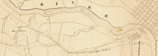
The Chesterfield Railroad was located in Chesterfield County, Virginia. It was a 13-mile (21-kilometer) long mule-and-gravity powered line that connected the Midlothian coal mines with wharves that were located at the head of navigation on the James River just below the Fall Line at Manchester. It began operating in 1831 as Virginia's first common carrier railroad.

The Richmond–Petersburg Turnpike was a controlled-access toll road located in the Richmond-Petersburg region of central Virginia, United States.

<span class="mw-page-title-main">Midlothian, Virginia</span> Unincorporated community in Virginia, United States

Midlothian is an unincorporated area and Census-designated place in Chesterfield County, Virginia, U.S. Settled as a coal town, Midlothian village experienced suburbanization effects and is now part of the western suburbs of Richmond, Virginia south of the James River in the Greater Richmond Region. Because of its unincorporated status, Midlothian has no formal government, and the name is used to represent the original small Village of Midlothian and a vast expanse of Chesterfield County in the northwest portion of Southside Richmond served by the Midlothian post office.

<span class="mw-page-title-main">History of Richmond, Virginia</span>

The history of Richmond, Virginia, as a modern city, dates to the early 17th century, and is crucial to the development of the colony of Virginia, the American Revolutionary War, and the Civil War. After Reconstruction, Richmond's location at the falls of the James River helped it develop a diversified economy and become a land transportation hub.

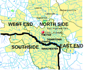
The Greater Richmond, Virginia area has many neighborhoods and districts.

<span class="mw-page-title-main">Virginia State Route 76</span> State highway in central Virginia, US

State Route 76 is a controlled-access toll road in the U.S. state of Virginia. Known as the Powhite Parkway, the state highway runs 13.04 miles (20.99 km) from SR 652 near Midlothian north to Interstate 195 (I-195) in Richmond. SR 76 connects SR 288, U.S. Route 60, and SR 150 in Chesterfield County with I-195 and SR 195 west of Downtown Richmond. The highway includes a pair of mainline barrier toll plazas and ramp toll plazas at most interchanges, all of which accept E-ZPass. SR 76 is maintained by the Virginia Department of Transportation (VDOT) in Chesterfield County and the Richmond Metropolitan Authority in the city of Richmond. The Richmond section of the freeway was constructed in the early 1970s; the highway was extended to its current terminus in Chesterfield County in the late 1980s.

<span class="mw-page-title-main">Virginia State Route 150</span> State highway in Virginia, United States

State Route 150 is a state highway in the U.S. state of Virginia. Known as Chippenham Parkway, the state highway runs 15.19 miles (24.45 km) from Interstate 95 (I-95) and SR 895 in Bensley north to Parham Road and River Road near Tuckahoe in Henrico County. SR 150 is a four- to six-lane circumferential highway that connects the Chesterfield County suburbs of Richmond with western Henrico County and, via SR 895, eastern Henrico County and Richmond International Airport. The highway is a freeway except for a short stretch east of SR 147 in Richmond. SR 150 has junctions with all of the radial highways south of the James River, including I-95, U.S. Route 1, US 301, US 360, US 60, and SR 76.

<span class="mw-page-title-main">Edward E. Willey Bridge</span> Bridge in Henrico County, Virginia

Edward E. Willey Bridge is a highway bridge which crosses the upper James River in the western portion of Henrico County, Virginia. It carries Chippenham Parkway between Parham Road in Henrico and the southwestern portion of the independent city of Richmond. It was named in honor of Edward E. Willey who was a pharmacist and state senator in the Virginia General Assembly from 1952 to 1983. He died in 1986.

<span class="mw-page-title-main">Virginia State Route 161</span> Highway in Richmond, Virginia, United States

State Route 161 is a primary state highway in and near Richmond, Virginia, United States. It extends from an interchange with Interstate 95 (I-95) in the independent city of Richmond north to an intersection with U.S. Route 1 in the Lakeside area of central Henrico County.

<span class="mw-page-title-main">Southside (Richmond, Virginia)</span> Neighborhood of Richmond, Virginia, United States

The Southside of Richmond is an area of the Metropolitan Statistical Area surrounding Richmond, Virginia. It generally includes all portions of the City of Richmond that lie south of the James River, and includes all of the former city of Manchester. Depending on context, the term "Southside of Richmond" can include some northern areas of adjacent Chesterfield County, Virginia in the Richmond-Petersburg region. With minor exceptions near Bon Air, VA, the Chippenham Parkway forms the border between Chesterfield County and the City of Richmond portions of Southside, with some news agencies using the term "South Richmond" to refer to the locations in Southside located in the city proper.

<span class="mw-page-title-main">Virginia State Route 147</span> State highway in Virginia, US

State Route 147 is a primary state highway in the U.S. state of Virginia. The state highway runs 13.13 miles (21.13 km) from U.S. Route 60 in Midlothian east to US 60 in Richmond. In various places, it is known as Huguenot Road, River Road, Cary Street Road and Main Street. SR 147 connects Midlothian with the West End of Richmond via the Huguenot Memorial Bridge across the James River. Within Richmond, the state highway follows Cary Street, a major thoroughfare that connects the city's two major universities, the University of Richmond and Virginia Commonwealth University, with Downtown Richmond.

<span class="mw-page-title-main">Transportation in Richmond, Virginia</span>

Transportation in Richmond, Virginia and its immediate surroundings include land, sea and air modes. This article includes the independent city and portions of the contiguous counties of Henrico and Chesterfield. While almost all of Henrico County would be considered part of the Richmond area, southern and eastern portions of Chesterfield adjoin the three smaller independent cities of Petersburg, Hopewell, and Colonial Heights, collectively commonly called the Tri-Cities area. A largely rural section of southwestern Chesterfield may be considered not a portion of either suburban area.

The Richmond and Petersburg Railroad moved passengers and goods between Richmond and Petersburg from 1838 to 1898. It survived the American Civil War and eventually merged into the Atlantic Coast Line Railroad in 1900.

<span class="mw-page-title-main">U.S. Route 1 in Virginia</span> Section of United States Numbered Highway in Virginia

U.S. Route 1 (US 1) is a major north–south U.S. Route that serves the East Coast of the United States. In the U.S. state of Virginia, US 1 runs north–south through South Hill, Petersburg, Richmond, Fredericksburg, and Alexandria on its way from North Carolina to the 14th Street bridges into the District of Columbia. It is completely paralleled by Interstate Highways in Virginia—Interstate 85 (I-85) south of Petersburg, I-95 north to Alexandria, and I-395 into the District of Columbia—and now serves mainly local traffic. At its north end, on the approach to the 14th Street bridges, US 1 is concurrent with I-395; the rest of US 1 is on surface roads.

<span class="mw-page-title-main">U.S. Route 60 in Virginia</span> Section of U.S. Numbered Highway in Virginia, United States

U.S. Route 60 (US 60) in the Commonwealth of Virginia runs 303 miles (488 km) west to east through the central part of the state, generally close to and paralleling the Interstate 64 corridor, except for the crossing of the Blue Ridge Mountains, and in the South Hampton Roads area.

Warwick Road in Chesterfield County, Virginia, was one of the older roadways in the area extending across the northern section of the county. Established in the 18th century in the Virginia Colony, the Warwick Road effectively provided a portage around the portion of the James River containing dams and rapids near the fall line in the area of the towns of Manchester and Richmond, Virginia, which were located along the south and north banks of the river respectively.

The Manchester Turnpike was a turnpike in Chesterfield County in the U.S. state of Virginia, and was the first paved or artificial roadway in that state. It stretched from Manchester west to Falling Creek near Midlothian, and is now known as Midlothian Turnpike, mostly forming part of U.S. Route 60 (US 60).

<span class="mw-page-title-main">Black Heath</span> Building in miles northeast of Midlothian, Virginia

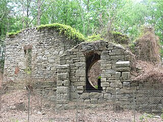
Black Heath was a house and coal mine located near the present day Midlothian area of Chesterfield County, Virginia. The Black Heath coal mining enterprises were operated intermittently from the early 1780s until 1939 and were most notably run by the Heth family from 1795 until 1840, who also built the mansion house in the early 1800s. During the early tenure of the Heths' operation, the Black Heath mines were one of the largest producers of coal in the United States and supplied coal to the White House during US President Thomas Jefferson's term. In 1840, control shifted to an English group of investors who oversaw the mines at a distance until 1888, when they were sold to another interest which soon went into trusteeship. During the 1910s or 1920s, the Black Heath house collapsed due to severe undermining from the numerous coal shafts and tunnels scattered around the property. In 1938, the Black Heath land was sold to coal mining interests who soon went into trusteeship and default like many others before them. Over the next few decades, the land sat idle until 1971, when it began to be parceled off into housing developments.

References

  1. Francis Earl Lutz, 1954, Chesterfield: An Old Virginia County, p. 49.
  2. 1 2 3 "National Register Information System". National Register of Historic Places . National Park Service. March 13, 2009.
  3. 1 2 3 "Virginia Landmarks Register". Virginia Department of Historic Resources. Archived from the original on 21 September 2013. Retrieved 19 March 2013.
  4. Lutz, p. 277
  5. Lutz, p. 282
  6. "Archived copy" (PDF). Archived from the original (PDF) on January 16, 2010. Retrieved January 17, 2010.{{cite web}}: CS1 maint: archived copy as title (link)

37°31′16″N77°26′39″W / 37.52111°N 77.44417°W / 37.52111; -77.44417