Gilpin is a small neighborhood located in Richmond, Virginia and within the boundaries of the North Side of the city limits. Originally part and parcel of the historically Black neighborhood of Jackson Ward, the northern section of that neighborhood was heavily redeveloped with the provision of public housing from the mid-20th century onwards, with the major development taking the name "Gilpin Court". During the same period, a massive expansion of highway building around and through central Richmond saw the Gilpin Court and the rest of the neighborhood essentially cut off from the rest of Jackson Ward.
The community of Gilpin lies adjacent to the interchange of Interstates 64 and 95, and houses three cemeteries: Hebrew Cemetery, Shockoe Hill Cemetery, and the long invisible Shockoe Hill African Burying Ground. The headquarters for the Richmond Department of Redevelopment and Housing are situated in the neighborhood along with the Richmond Alternative School.
Most of the western part of the neighborhood is occupied with higher density structure, but housing becomes less dense towards the eastern part of the community.

Oregon Hill is a historic working-class neighborhood in Richmond, Virginia. Oregon Hill overlooks the James River and Belle Isle, and provides access to Hollywood Cemetery. Due to the neighborhood's proximity to the Monroe Park Campus of Virginia Commonwealth University, the neighborhood is sometimes referred to as a student quarter because of its high college student population.

The history of Richmond, Virginia, as a modern city, dates to the early 17th century, and is crucial to the development of the colony of Virginia, the American Revolutionary War, and the Civil War. After Reconstruction, Richmond's location at the falls of the James River helped it develop a diversified economy and become a land transportation hub.
The Greater Richmond, Virginia area has many neighborhoods and districts.

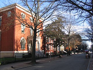
Jackson Ward, previously known as Central Wards, is a historically African-American district in Richmond, Virginia, with a long tradition of African-American businesses. It is located less than a mile from the Virginia State Capitol, sitting to the west of Court End and north of Broad Street. It was listed as a National Historic Landmark District in 1978. "Jackson Ward" was originally the name of the area's political district within the city, or ward, from 1871 to 1905, yet has remained in use long after losing its original meaning.
Fulton Hill is a neighborhood located in the East End of Richmond, Virginia. The name is used for the area stretching from Gillies Creek to the Richmond city limits. The Greater Fulton Hill Civic Association includes Fulton Bottom, part of Montrose Heights and part of Rocketts. Fulton Hill is south of Church Hill and Shockoe Bottom, north of Varina, east of the James River, and west of Sandston. The zip code is 23231.

Oakwood Cemetery is a large, city-owned burial ground in the East End of Richmond, Virginia. It holds over 48,000 graves, including many soldiers from the Civil War.

The Fifth Street Viaduct or the Fifth Street Bridge, officially the Curtis Holt Sr. Bridge, is a bridge crossing Bacon's Quarter Branch in the Shockoe Valley of Richmond, Virginia in the United States. It carries automobile and pedestrian traffic between Downtown Richmond's Jackson Ward and Gilpin Court with the North Side's Chestnut Hill and Highland Park.
Upper Shockoe Valley is a neighborhood in Richmond, Virginia that straddles alongside Interstate 95. The name is given based on the Shockoe River Valley created within the boundaries of the neighborhood.
Creighton Court is a neighborhood in Richmond, Virginia's East End region. Creighton Court sits on the border between the City of Richmond and eastern Henrico County. The neighborhood is situated directly north of the Oakwood Cemetery and alongside the interchange of Virginia Route 33 and Interstate 64. North 29th Street and Creighton Road serve as the main arteries of the community.

Mosby Court is a Housing Project also a neighborhood. The neighborhood is named Mosby while the Housing Project is named Mosby Court. Mosby Court is located in the East End quadrant of Richmond, Virginia Adjacent to the Richmond City Jail, Mosby Court is primarily served by Coalter Street, which accesses the community North 18th Street. Directly south of the neighborhood is Martin Luther King Jr. Middle School.
Randolph is a historically black middle class neighborhood located within the West End of Richmond, Virginia. The neighborhood is named in honor of Virginia E. Randolph, a former African-American educator in Henrico County, Virginia during the 19th century. The neighborhood is bounded by the Downtown Expressway to the north, Harrison Street to the east, Colorado Avenue to the south, and South Meadow street to the west. Some famous landmarks and places of interest in the neighborhood include Petronius Park, the Randolph Community Center, and just adjacent to the neighborhood, the Hollywood Cemetery.
The Shockoe Hill African Burying Ground was established by the city of Richmond, Virginia, for the interment of free people of color, and the enslaved. The heart of this now invisible burying ground is located at 1305 N 5th St.

The Shockoe Hill Burying Ground Historic District, located in the city of Richmond, Virginia, is a significant example of a municipal almshouse-public hospital-cemetery complex of the sort that arose in the period of the New Republic following disestablishment of the Anglican Church. The District illustrates changing social and racial relationships in Richmond through the New Republic, Antebellum, Civil War, Reconstruction, and Jim Crow/Lost Cause eras of the nineteenth and twentieth centuries. The Shockoe Hill Burying Ground Historic District occupies 43 acres (17 ha) of land bounded to the south by E. Bates Street, to the north by the northern limit of the Virginia Passenger Rail Authority right-of-way at the southern margin of the Bacon's Quarter Branch valley, to the west by 2nd Street, and to the east by the historic edge of the City property at the former location of Shockoe Creek. The District encompasses most of a 28.5-acre (11.5 ha) tract acquired by the city of Richmond in 1799 to fulfill several municipal functions, along with later additions to this original tract.
This page is based on this
Wikipedia article Text is available under the
CC BY-SA 4.0 license; additional terms may apply.
Images, videos and audio are available under their respective licenses.