Governador Valadares, Minas Gerais

Last updated
Governador Valadares
Municipality of Governador Valadares
Governador Valadares - Leste de Minas - 2.jpg
Fachada da Catedral de Santo Antonio.jpg
MG - Parque Municipal de Governador Valadares - Estufa.jpg
HospitalUnimedGV.jpg
Governador Valadares, MG - panoramio (4).jpg
Valadares .jpg
PicoIbituruna-GovernadorValadares.jpg
Governador Valadares
Bandeira de Governador Valadares.svg
Brasao GovernadorValadares MinasGerais Brasil.svg
Motto: 
Princesinha do Vale (Little Princess of the Valley)
MinasGerais Municip GovernadorValadares.svg
Location in the state of Minas Gerais
Brazil location map.svg
Red pog.svg
Governador Valadares
Coordinates: 18°51′03″S41°56′56″W / 18.85083°S 41.94889°W / -18.85083; -41.94889
CountryFlag of Brazil.svg  Brazil
State Bandeira de Minas Gerais.svg  Minas Gerais
Region Southeast
Intermediate Region Governador Valadares
Immediate Region Governador Valadares
Founded30 January 1938
Government
  MayorAndré Merlo (PSDB)
Area
  Total2,348.1 km2 (906.6 sq mi)
Elevation
170 m (560 ft)
Population
 (2020 est.) [1]
  Total281,046
  Density120/km2 (310/sq mi)
Demonym valadarense
Time zone UTC−3 (BRT)
HDI (2010)0.727 – high [2]
Website www.valadares.mg.gov.br

Governador Valadares is a Brazilian municipality in the countryside of Minas Gerais. In 2020, its population was 281,046 inhabitants, thus being the ninth most populated city in the state. [1] It is an economical axis of the middle valley of the Doce River (Rio Doce, lit. "Sweet River"), having a significant influence on the east and northeast portion of Minas Gerais and local authorities of the state of Espírito Santo. Governador Valadares sits on the bank of the Doce River (Rio Doce), 324 km from Belo Horizonte, the state's capital. Governador Valadares has an area of about 2 342 km2, of which only 58 km2 is urban area.

Contents

The discovery of the city started at the beginning of the 16th century, that explored the Doce River searching for precious metals. The settlement began between the 18th and 19th centuries, constructing barracks destined to keep an eye at the Amerindians, who used to attack the settlers and merchants. With the construction of the EFVM (Vitória-Minas Railway), in 1907, the settlements were consolidated. The growth of the population and commercial development was improved due to the location of the city, that was near to coffee farms and wood extraction fields. The municipality was emancipated from Peçanha in the 1930s.

After the 1940s, the extraction of precious metals brought a notable population growth, along with livestock and commerce. However, with the decline of natural resources, the money could only be earned through the investment of immigrants, who would later go to other countries. Commerce is the most important source of income in the city, along with agribusiness and regional manufactured products.

Geography

According to the modern (2017) geographic classification by Brazil's National Institute of Geography and Statistics (IBGE), the city is the main municipality in the Intermediate Geographic Region of Governador Valadares.

Until 2017, Governador Valadares was a statistical micro-region including 25 municipalities: Alpercata, Campanário, Capitão Andrade, Coroaci, Divino das Laranjeiras, Engenheiro Caldas, Fernandes Tourinho, Frei Inocêncio, Galiléia, Governador Valadares, Itambacuri, Itanhomi, Jampruca, Marilac, Mathias Lobato, Nacip Raydan, Nova Módica, Pescador, São Geraldo da Piedade, São Geraldo do Baixio, São José da Safira, São José do Divino, Sobrália, Tumiritinga, and Virgolândia. Its population (2006) was estimated by the IBGE to be 407,815 inhabitants in a total area of 11, 327 km2.

Climate

Temperature:

Average annual rainfall index: 1,350 mm

Climate

Climate data for Governador Valadares (1981–2010)
MonthJanFebMarAprMayJunJulAugSepOctNovDecYear
Mean daily maximum °C (°F)32.2
(90.0)
33.2
(91.8)
32.2
(90.0)
30.7
(87.3)
28.7
(83.7)
27.9
(82.2)
27.8
(82.0)
28.6
(83.5)
29.7
(85.5)
30.9
(87.6)
30.8
(87.4)
31.2
(88.2)
30.3
(86.5)
Daily mean °C (°F)26.5
(79.7)
26.6
(79.9)
26.1
(79.0)
24.8
(76.6)
22.5
(72.5)
21.1
(70.0)
20.9
(69.6)
21.9
(71.4)
23.7
(74.7)
25.0
(77.0)
25.8
(78.4)
25.9
(78.6)
24.2
(75.6)
Mean daily minimum °C (°F)21.9
(71.4)
21.6
(70.9)
21.3
(70.3)
20.1
(68.2)
17.5
(63.5)
15.8
(60.4)
15.2
(59.4)
16.4
(61.5)
18.0
(64.4)
19.7
(67.5)
20.7
(69.3)
21.5
(70.7)
19.1
(66.4)
Average precipitation mm (inches)173.0
(6.81)
83.5
(3.29)
113.0
(4.45)
48.8
(1.92)
23.1
(0.91)
13.6
(0.54)
8.0
(0.31)
13.6
(0.54)
33.9
(1.33)
69.8
(2.75)
170.4
(6.71)
234.9
(9.25)
985.6
(38.80)
Average precipitation days (≥ 1.0 mm)10795322236111474
Average relative humidity (%)78.676.377.678.678.178.375.372.068.869.675.778.475.6
Mean monthly sunshine hours 196.4188.5187.1177.4161.6157.8168.0178.3145.0145.4128.7138.91,973.1
Source: Instituto Nacional de Meteorologia [3]

History

Colonization of the region

Today's location of the municipality of Governador Valadares was found to be inhabited by Amerindians for at least 10 thousand years and registers from the first explorers of the region after Brazil's discovery, in 1500, provides us information that they were still numerous on that occasion. [4] The exploration of this region began in the 16th century, with expeditions like the ones from Sebastião Fernandes Tourinho, that went by the Rio Doce route in the search for precious metals. [5] Fernandes Tourinho went through the inverse route of the river until finding the Santo Antônio River, [4] but the settlement was prohibited in the beginning of the 17th century, due to the efforts to not having ways to have illegal gold extraction on the Diamantina, Minas Gerais region. [6]

The settlement was allowed on 1755 [6] and to guarantee to safety of the colonizers and merchants that used the Doce River, barracks were installed with the mission to keep an eye on the Botocudos. [7] [8] The barrack of Baguari was the first territory of today's municipality and along with him, near settlements also appeared, one of them being Figueira, that correspond to today's municipality. The Amerindians were seen as a threat to the colonizers and the barracks worked as a strategy of forcing them to leave the region. Near Figueira, in 1818, the D.Manoel barrack was created, on the left side of the Doce River, working as a little port that attended to military service and would also form a trading post. [4] Later, the settlement was ranked up to a district subjected to Peçanha by the provincial law nº 3.198 of September 23 of 1884, coming to be called Santo Antônio da Figueira. [7]

General information

The area around Governador Valadares was explored in colonial serve the residences of the town. It was powered by steam.

  • 1923 – Figueira

In 1937, the municipality of Figueira do Rio Doce was established, which then changed its name to Governador Valadares, in honor of the governor at the time, Benedito Valadares.

Since the 1980s, Governador Valadares is known as one of the main sources of Brazilian immigrants to the United States, even earning the nickname "Governador Valadolares" in reference to expatriates sending remittances of their dollar salaries. However, the late 2000s recession made many of the Valadares immigrants to return home since financial security became worse in the United States. [9] [10]

Economy

Production and the intense trade in precious stones is the reason the "Brazil Gem Show" takes place in the local authority every year: an event that consists of the commerce of precious stones with Brazilians and foreign visitors

Governador Valadares is the biggest city and commercial center of the Eastern region of the state of Minas Gerais, having several cities in its area of influence, such as Teófilo Otoni and Caratinga. At present, Governador Valadares is growing in industrial development, due to its strategic position, human resources and international reputation.

It is a trade and industrial center. Sawmills and food-processing plants are in the city, and mica and beryl are mined in the area. Governador Valadares is one of the most famous gem-trading centres in Brazil. Gem minerals include amethyst, chrysoberyl, brazilianite, topaz and quartz. The Golconda mine, one of the oldest in the city, attracts the curiosity of tourists and stone collectors from all over the world.

Transportation

The city is served by the railroad Vitória-Minas, of Vale S.A. and by the highway Rio-Bahia (BR-116). It is also connected with the capital of the state by the BR-381.

The city is on the Belo Horizonte–Vitória railway and on the Rio de Janeiro–Salvador highway. Distances from major centers:

Sport

The city hosts of one of the stages of the Brazilian hang gliding championship from the peak of Ibituruna, where it is possible to catch sight of the whole valley of Rio Doce. It also hosts several international hang gliding championships.

The city is known internationally for the World Paragliding Championships that has been held at Ibituruna Peak (1123 meters).

Neighborhoods

Sister cities

Governador Valadares is twinned with the following cities:

Notable people

Related Research Articles

<span class="mw-page-title-main">Minas Gerais</span> State in Southeastern Brazil

Minas Gerais is one of the 27 federative units of Brazil, being the fourth largest state by area and the second largest in number of inhabitants with a population of 20,539,989 according to the 2022 census. Located in the Southeast Region of the country, it is limited to south and southwest with São Paulo; Mato Grosso do Sul to the west; Goiás and the Federal District to the northwest; Bahia to the north and northeast; Espírito Santo to the east; and Rio de Janeiro to the southeast. The state's capital and largest city, Belo Horizonte, is a major urban and finance center in Brazil, being the sixth most populous municipality in the country while its metropolitan area ranks as the third largest in Brazil with just over 5.8 million inhabitants, after those of São Paulo and Rio de Janeiro. Minas Gerais' territory is subdivided into 853 municipalities, the largest number among Brazilian states.

<span class="mw-page-title-main">Manhuaçu</span> Municipality in Southeast, Brazil

Manhuaçu is a municipality in Eastern Minas Gerais state, in Brazil. Its population was 91,169 (2020) and its area is 628 km2.

<span class="mw-page-title-main">Montes Claros</span> Municipality in Southeast, Brazil

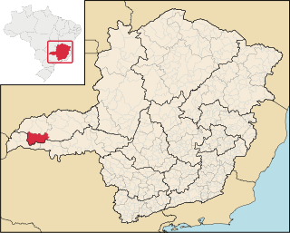
Montes Claros is a city located in northern Minas Gerais state, in Brazil. It is located north of the state capital, about 422 km away from it. The population is 413,487 in an area of 3,569 km2 (1,378 sq mi). It was made a seat of a municipality in 1831 and attained city status in 1857.

<span class="mw-page-title-main">Baixo Guandu</span> Municipality in Southeast, Brazil

Baixo Guandu is a municipality located in the Brazilian state of Espírito Santo that was founded on April 10, 1935 and established as a city on June 8, same year. The city's celebration day is April 10. Its population was 31,132 (2020) and its area is 918 km². The area is most well known for its exports of coffee, especially from the high mountains of the district of Alto Mutum Preto. The main watercourse through the municipality is the Rio Doce river whose basin is composed of 222 municipalities.

<span class="mw-page-title-main">Luz, Minas Gerais</span> Municipality in Southeast, Brazil

Luz is a Brazilian municipality located in the West part of the state of Minas Gerais. Luz is located between the city of Araxá and the capital city of the state of Minas Gerais, Belo Horizonte. The population is 18,257 in an area of 1172 km2. The city belongs to the Central Mineira region and to the micro-region of Bom Despacho. It became a municipality in 1923.

<span class="mw-page-title-main">Alpercata</span> Brazilian municipality located in the northeast of the state of Minas Gerais

Alpercata is a Brazilian municipality located in the northeast of the state of Minas Gerais. Its population as of 2020 was 7,436 people living in a total area of 167 km2. The city belongs to the meso-region of Vale do Rio Doce and to the micro-region of Governador Valadares. It became a municipality in 1962.

<span class="mw-page-title-main">Teófilo Otoni</span> Municipality in Southeast, Brazil

Teófilo Otoni is a municipality in northeast Minas Gerais, Brazil. The population of the municipality was 140,937 in 2020 and the area is 3,242.818 km2.

<span class="mw-page-title-main">Doce River</span> River in Brazil

The Doce River is a river in southeast Brazil with a length of 853 kilometres (530 mi). The river basin is economically important. In 2015, the collapse of a dam released highly contaminated water from mining into the river, causing an ecological disaster.

<span class="mw-page-title-main">Ipatinga</span> City in Minas Gerais, Brazil

Ipatinga is a municipality in eastern Minas Gerais state, Brazil. The city was founded on 29 April 1964 and covers a total area of 164.8 km2 (63.6 sq mi). Its population is 227,731 as of 2022. It is part of the Vale do Aço metropolitan area.

<span class="mw-page-title-main">Coronel Fabriciano</span> Municipality in Southeast, Brazil

Coronel Fabriciano is a municipality in the state of Minas Gerais in the Southeast region of Brazil. It is located in the region of Vale do Rio Doce and is situated 200 km from the state capital. The municipal population was estimated in 2020 by IBGE in 110,290 inhabitants. The area is 221.252 km2 (85.426 sq mi).

<span class="mw-page-title-main">Araxá</span> Municipality in Brazil

Araxá is a municipality in Western Minas Gerais state, Brazil. Its estimated population by IBGE in 2020 is 107,337 inhabitants and the area of the municipality is 1,283 square kilometres (495 sq mi), with 3.45 square kilometres (1.33 sq mi) making up the urban perimeter.

<span class="mw-page-title-main">Ponte Nova</span> Municipality in central-eastern Minas Gerais state, Brazil

Ponte Nova is a municipality in central-eastern Minas Gerais state, Brazil.

<span class="mw-page-title-main">Esporte Clube Democrata</span> Football club

Esporte Clube Democrata, usually known simply as Democrata de Governador Valadares, Democrata-GV, or just Democrata, is a traditional Brazilian football club from Governador Valadares, Minas Gerais state.

<span class="mw-page-title-main">Roman Catholic Archdiocese of Mariana</span> Catholic ecclesiastical territory

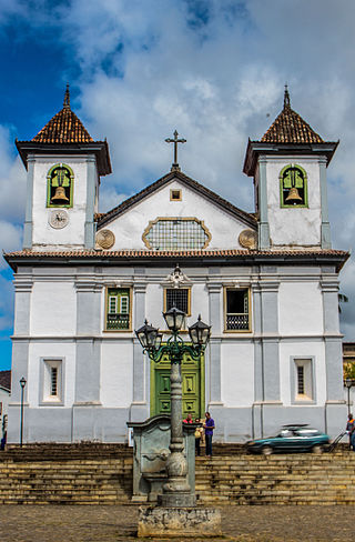
The Roman Catholic Archdiocese of Mariana is an archdiocese based in the city of Mariana in the Brazilian state of Minas Gerais.

<span class="mw-page-title-main">Campina Verde</span> Municipality in the north of the Brazilian state of Minas Gerais

Campina Verde is a municipality in the north of the Brazilian state of Minas Gerais. As of 2020 the population was 19,752 in a total area of 3,663 km². It became a municipality in 1938.

<span class="mw-page-title-main">Campanário, Minas Gerais</span> Brazilian municipality located in the northeast of the state of Minas Gerais

Campanário is a Brazilian municipality located in the northeast of the state of Minas Gerais. Its population as of 2020 was 3,730 people living in a total area of 441 km². The city belongs to the meso-region of Vale do Rio Doce and to the micro-region of Governador Valadares. It became a municipality in 1943.

<span class="mw-page-title-main">Coroaci</span> Brazilian municipality located in the northeast of the state of Minas Gerais

Coroaci is a Brazilian municipality located in the east of the state of Minas Gerais. Its population as of 2010 was 10,270 people living in a total area of 576 km². The city belongs to the meso-region of Vale do Rio Doce and to the micro-region of Governador Valadares. It became a municipality in 1949.

<span class="mw-page-title-main">Mantena, Minas Gerais</span> Municipality in Southeast, Brazil

Mantena is a municipality in the state of Minas Gerais in the Southeast region o Brazil.

<span class="mw-page-title-main">Immediate Geographic Region of Governador Valadares</span> Urban administrative region in Minas Gerais, Brazil

The Immediate Geographic Region of Governador Valadares is one of the 4 immediate geographic regions in the Intermediate Geographic Region of Governador Valadares, one of the 70 immediate geographic regions in the Brazilian state of Minas Gerais and one of the 509 of Brazil, created by the National Institute of Geography and Statistics (IBGE) in 2017.

<span class="mw-page-title-main">Immediate Geographic Region of Guanhães</span> Urban administrative region in Minas Gerais, Brazil

The Immediate Geographic Region of Guanhães is one of the 4 immediate geographic regions in the Intermediate Geographic Region of Governador Valadares, one of the 70 immediate geographic regions in the Brazilian state of Minas Gerais and one of the 509 of Brazil, created by the National Institute of Geography and Statistics (IBGE) in 2017.

References

  1. 1 2 IBGE 2020
  2. "Archived copy" (PDF). United Nations Development Programme (UNDP). Archived from the original (PDF) on 8 July 2014. Retrieved 13 March 2022.{{cite web}}: CS1 maint: archived copy as title (link)
  3. "Normais Climatológicas Do Brasil 1981–2010" (in Portuguese). Instituto Nacional de Meteorologia. Retrieved 21 May 2024.
  4. 1 2 3 "PMSB" (PDF).
  5. "IBGE".
  6. 1 2 "CTMAMG". Archived from the original on 2014-02-21.
  7. 1 2 "IBGE".
  8. "Valadares".
  9. Longing for ginger ale
  10. Leaving Valadares: A Dangerous Journey for Brazil's Illegal Migrants
  11. Sister Cities International 2015 Membership Directory, p 53. Sister Cities International. Accessed August 31, 2015.

18°51′S41°56′W / 18.850°S 41.933°W / -18.850; -41.933