This is a list of cities, towns and villages in Zimbabwe. See also: Place names in Zimbabwe.
This is a list of cities, towns and villages in Zimbabwe. See also: Place names in Zimbabwe.


| Cities in Zimbabwe [1] | |||||||
|---|---|---|---|---|---|---|---|
| City | Province | Census 1982 | Census 1992 | Census 2002 | Census 2012 | Census 2022 | |
| Harare | Harare | 656,011 | 1,189,103 | 1,435,784 | 1,485,231 | 1,849,600 | |
| Bulawayo | Bulawayo | 413,814 | 621,742 | 676,650 | 653,337 | 665,940 | |
| Chitungwiza | Harare | 172,556 | 274,912 | 323,260 | 356,840 | 371,244 | |
| Mutare | Manicaland | 69,621 | 131,367 | 170,466 | 186,208 | 224,802 | |
| Epworth | Harare | – | – | 114,067 | 167,462 | ||
| Gweru | Midlands | 78,918 | 128,037 | 140,806 | 154,825 | 161,292 | |
| Kwekwe | Midlands | 47,607 | 75,425 | 93,608 | 100,900 | 119,863 | |
| Kadoma | Mashonaland West | 44,613 | 67,750 | 76,351 | 91,633 | 117,380 | |
| Masvingo | Masvingo | 30,523 | 51,743 | 69,993 | 87,866 | 90,286 | |
| Chinhoyi | Mashonaland West | 24,322 | 43,054 | 48,912 | 68,273 | 103,671 | |
| Norton | Mashonaland West | - | 20,405 | 44,397 | 67,591 | 87,038 | |
| Marondera | Mashonaland East | 24,322 | 43,054 | 51,847 | 61,998 | 66,203 | |
| Ruwa | Mashonaland East | – | – | 22,155 | 56,678 | 94,083 | |
| Chegutu | Mashonaland West | 19,606 | 30,191 | 43,424 | 50,255 | ||
| Zvishavane | Midlands | 26,597 | 32,984 | 35,128 | 45,230 | ||
| Bindura | Mashonaland Central | 18,243 | 21,167 | 33,637 | 42,861 | ||
| Beitbridge | Matabeleland South | – | 11,596 | 21,906 | 41,767 | ||
| Redcliff | Midlands | 22,109 | 29,959 | 32,417 | 35,904 | ||
| Victoria Falls | Matabeleland North | 8,126 | 16,826 | 31,519 | 33,660 | ||
| Hwange | Matabeleland North | 7,125 | 14,878 | 30,519 | 33,210 | ||
| Rusape | Manicaland | 8,216 | 13,920 | 22,741 | 30,316 | ||
| Chiredzi | Masvingo | 10,257 | 21,116 | 25,849 | 30,197 | ||
| Kariba | Mashonaland West | 12,364 | 20,736 | 22,726 | 26,112 | ||
| Karoi | Mashonaland West | 8,748 | 14,763 | 22,383 | 26,009 | ||
| Chipinge | Manicaland | 6,077 | 11,582 | 16,539 | 25,214 | ||
| Gokwe | Midlands | – | 7,418 | 17,703 | 23,906 | ||
| Shurugwi | Midlands | 13,255 | 16,138 | 16,863 | 21,501 | ||

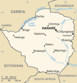
Midlands is a province of Zimbabwe. It has an area of 49,166 square kilometres (18,983 sq mi) and a population of 1,811,905 (2022). It is home to various peoples. Located at a central point in the country, it contains speakers of Shona, Ndebele, Tswana, Sotho and Chewa, as well as of various other languages. Gweru, the third-largest city in Zimbabwe, is the capital of the province.

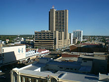
Gweru, originally known as Gwelo, is a city in central Zimbabwe. It is on the centre of Midlands Province. Originally an area known to the Ndebele as "The Steep Place" because of the Gweru River's high banks, in 1894 it became the site of a military outpost established by Leander Starr Jameson. In 1914 it attained municipal status, and in 1971 it became a city.

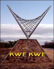
Kwekwe, formerly known as Que Que, is a city in the Midlands province in central Zimbabwe. The city has a population of 119,863 within the city limits, as of the 2022 census, making it the 7th-largest city in Zimbabwe and the second-most populous city in the Midlands, behind Gweru.

The Republic of Zimbabwe is broken down into 10 administrative provinces, which are divided into 64 districts and 1,970 wards.
Shurugwi Rural Areas, also known as Shurugwi District, is a rural area around Shurugwi, Zimbabwe, mainly to the east, beginning 20 kilometres from the town centre. The area between the town and the rural areas was mainly occupied by white commercial farmers. It is thought that at one time, these farms were owned by three families who were all related. The total area of these farms is approximately 60 km x 40 km similar to an area that was occupied by more than 4,000 African families. Most of the black families are subsistence farmers. Maize is generally grown by the majority.
Cha Cha Cha Township or simply known as Cha Cha Cha is a rural shopping centre in Shurugwi Rural Areas, 24 km South East of Shurugwi along the Beit Bridge road and 60 km (37 mi) from Gweru. The tarred road from 12 km before Shurugwi was constructed by a Chinese company called China-Gansui and is considered one of the best located rural shopping centres in Zimbabwe, therefore it can not be considered a remote area. It is relatively below standards with potholes and experienced sinking in some stages, and was heavily affected by the floods during the summer of 2000.

Kwekwe, originally known as Que Que, is a district in Zimbabwe. 197,062 people live in Kwekwe rural and 119,863 live in Kwekwe town.

Shurugwi, originally known as Selukwe, is a district located in Midlands Province, southern Zimbabwe. 98,315 people live in Shurugwi rural and 23,304 live in Shurugwi town.
Gokwe North District is the northern of two administrative districts in the Gokwe region of the Midlands province of Zimbabwe. Its administrative seat is Nembudziya.
The Gwenoro Dam is located inside Gwenoro Farm, an estate formerly owned by Ian Douglas Smith (1919-2007), a former Prime Minister of Rhodesia. The farm was seized in stages by the Government of Zimbabwe from Ian Smith and his family between 2002 and December 2012. The Gwenoro Dam supplies water to nearby Gweru and Shurugwi in Zimbabwe. The dam is constructed on the Runde River. The name Gwenoro is derived from a wild animal found in the area known in the local language of Shona as Nhoro (gweNORO), which means a 'place inhabited by Nhoro'. The area is very beautiful and picturesque. The dam is full from January to June. Fish co-operatives are sprouting around the banks of this river. ZIMASCO used to run a mine club but has since stopped. What remains are only buildings.

The geology of Zimbabwe in southern Africa is centered on the Zimbabwe Craton, a core of Archean basement composed in the main of granitoids, schist and gneisses. It also incorporates greenstone belts comprising mafic, ultramafic and felsic volcanics which are associated with epiclastic sediments and iron formations. The craton is overlain in the north, northwest and east by Proterozoic and Phanerozoic sedimentary basins whilst to the northwest are the rocks of the Magondi Supergroup. Northwards is the Zambezi Belt and to the east the Mozambique Belt. South of the Zimbabwe Craton is the Kaapvaal Craton separated from it by the Limpopo Mobile Belt, a zone of deformation and metamorphism reflecting geological events from Archean to Mesoproterozoic times. The Zimbabwe Craton is intruded by an elongate ultramafic/mafic igneous complex known as the Great Dyke which runs for more than 500 km along a SSW/NNE oriented graben. It consists of peridotites, pyroxenites, norites and bands of chromitite.

Gweru District is a district in the [[Midlands it is the center of Zimbabwe. .(Zimbabwe)|Midlands]] Province of Zimbabwe.

Gokwe North Rural District Councils is a local government organ administering Gokwe North District. There are eight Rural District Councils in the Midlands Province of Zimbabwe all established in terms of the Zimbabwe Rural District Councils Act; Chapter 29.13.
Tongogara Rural District Council is a local government organ administering Shurugwi District Rural District. There are two local government arms, Shurugwi Town Council created under the Zimbabwe Urban Councils Act, Chapter 29.15 administering Shurugwi, and Tongogara RDC created in terms of the Zimbabwe Rural District Councils Act, Chapter 29.13 overseeing the rural Shurugwi South District
Zvishavane District is one of the eight districts in Midlands Province of Zimbabwe. 85,035 people live in Zvishavane rural and 59,714 live in Zvishavane town.
The A5 Highway is a national road in Zimbabwe. It joins the cities of Harare and Bulawayo, and is hence known as the Harare-Bulawayo Highway. It is one of the two routes that form the R2 Route, which connects Harare with the Plumtree Border with Botswana.
A18 Road is a national road running from Gweru to Zvishavane/A9 Highway junction in central Zimbabwe. It begins in Gweru at the roundabout where 7th Street ends. 19°27′34″S29°49′27″E and ends at the intersection with A9/P7 Highway just after Zvishavane town. 20°18′51″S30°03′09″E
Morgan Mahanya is a Zimbabwean Shona-language writer of detective fiction and war fiction. He has published 13 books since 1976, including books in Shona and in English, both fiction and nonfiction. Mahanya is one of the pioneering writers of detective stories in the Shona language. His books Chidamwoyo, Zvinoyera and The Wound are about the Rhodesian Bush War.

Beira-Bulawayo railway, also called Machipanda railway, Beira-Harare-Bulawayo railway and Beira railway, is a railway that connects the city of Beira, Mozambique, to the city of Bulawayo, in Zimbabwe. It is 850 km long, in a 1067 mm gauge.