


A rock formation is an isolated, scenic, or spectacular surface rock outcrop. Rock formations are usually the result of weathering and erosion sculpting the existing rock. The term rock formation can also refer to specific sedimentary strata or other rock unit in stratigraphic and petrologic studies.
Contents
- Asia
- Armenia
- China
- Hong Kong
- Jordan
- India
- Israel
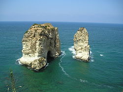
- Lebanon
- Mongolia
- Pakistan
- Thailand
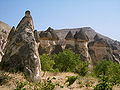
- Turkey
- Other countries
- Africa
- Kenya
- Libya
- Madagascar
- Mauritania
- Namibia
- Nigeria
- South Africa
- North America
- United States
- Canada
- Caribbean
- Mexico
- Central America
- South America
- Argentina
- Bolivia
- Brazil
- Chile
- Colombia
- Ecuador
- Falkland Islands
- Paraguay
- Peru
- Uruguay
- Venezuela
- Europe
- Albania
- Bosnia and Herzegovina
- Bulgaria
- Croatia
- Czech Republic
- Denmark
- Estonia
- Finland
- France
- Georgia
- Germany
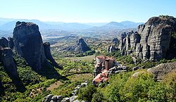
- Greece
- Gibraltar
- Bailiwick of Guernsey
- Iceland
- Ireland
- Italy
- Latvia
- North Macedonia
- Malta
- Isle of Man
- Norway
- Poland
- Portugal
- Romania
- Russia
- Serbia
- Spain
- Sweden
- Switzerland
- Slovakia
- Ukraine
- United Kingdom
- Oceania
- Australia
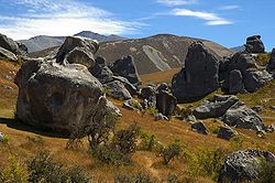
- New Zealand
- Other countries 2
- See also
- References
- External links
A rock structure can be created in any rock type or combination:
- Igneous rocks are created when molten rock cools and solidifies, with or without crystallisation. They may be either plutonic bodies or volcanic extrusive. Again, erosive forces sculpt their current forms.
- Metamorphic rocks are created by rocks that have been transformed into another kind of rock, usually by some combination of heat, pressure, and chemical alteration.
- Sedimentary rocks are created by a variety of processes but usually involving deposition, grain by grain, layer by layer, in water or, in the case of terrestrial sediments, on land through the action of wind or sometimes moving ice. Erosion later exposes them in their current form.
Geologists have created a number of terms to describe different rock structures in the landscape that can be formed by natural processes:
Here is an incomplete list of rock formations by continent.