
Mount Columbia is a mountain located in the Winston Churchill Range of the Rocky Mountains. It is the highest point in Alberta, Canada, and is second only to Mount Robson for height and topographical prominence in the Canadian Rockies. It is located on the border between Alberta and British Columbia on the northern edge of the Columbia Icefield. Its highest point, however, lies within Jasper National Park in Alberta.

Diadem Peak is a peak located in the Sunwapta River Valley of Jasper National Park, Canada. Diadem Peak is essentially the high point of a ridge leading down from the slightly higher Mount Woolley. This peak was the first 11,000er north of the Columbia Icefield to be climbed and one of the few peaks in the Canadian Rockies to be climbed before 1900.

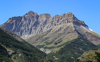
Mount Ball is a mountain located on the Continental Divide, on the borders of Banff and Kootenay national parks in Western Canada. Mt. Ball is the highest peak of the Ball Range in the Canadian Rockies.

Mount Stephen, 3,199 m (10,495 ft), is a mountain located in the Kicking Horse River Valley of Yoho National Park, 1⁄2 km east of Field, British Columbia, Canada. The mountain was named in 1886 for George Stephen, the first president of the Canadian Pacific Railway. The mountain is mainly composed of shales and dolomites from the Cambrian Period, some 550 million years ago. The Stephen Formation, a stratigraphical unit of the Western Canadian Sedimentary Basin was first described at the mountain and was named for it. Stephen has a subpeak known as Stephen SE1, at the end of a 1 km ridge, 132° from the main peak, visible from Lake O'Hara.

Mount Saskatchewan is a mountain located in the North Saskatchewan River valley of Banff National Park, in the Canadian Rockies of Alberta, Canada.

Mount Hector is a 3,394-metre (11,135-foot) mountain summit located in the Bow River valley of Banff National Park, in the Canadian Rockies of Alberta, Canada. The mountain was named in 1884 by George M. Dawson after James Hector, a geologist on the Palliser expedition. The mountain is located beside the Icefields Parkway, 17 km (11 mi) north of Lake Louise.
Mount Blakiston is a mountain in the southwestern corner of Alberta, Canada and the highest point within Waterton Lakes National Park. The mountain is situated in the Clark Range, north of Lineham Creek and south of Blakiston Creek. Blakiston's closest neighbours include Mount Hawkins 2,685 m (8,809 ft) directly to the west along a connecting ridge and Mount Lineham 2,728 m (8,950 ft) to the south.

Mount Balfour is a mountain located on the Continental Divide, part of the border between British Columbia and Alberta, in the Waputik Range in the Park Ranges of the Canadian Rockies. It is the 71st highest peak in Alberta and the 113th highest in British Columbia; it is also the 52nd most prominent in Alberta.

Mount Habel is a 3,073-metre (10,082-foot) mountain summit located in Banff National Park on the Continental Divide along the border of Alberta and British Columbia in the Waputik Mountains, part of the Canadian Rockies. It was named in 1986 after Jean Habel. Jean Habel was a German geographer who explored the Canadian Rockies and in 1897 was the first to set foot on the Wapta Icefield which surrounds Mount Habel.

Mount Bogart is a 3,144-metre (10,315-foot) summit located in Kananaskis Country in the Canadian Rockies of Alberta, Canada. Mount Bogart's nearest higher peak is Wind Mountain, 4.7 km (2.9 mi) to the north. Mount Bogart is situated northwest of Mount Kidd, and both can be seen from Highway 40 near the Kananaskis Village junction.

Wedgwood Peak is a 3,024-metre (9,921-foot) mountain summit located in Mount Assiniboine Provincial Park, in the Canadian Rockies of British Columbia, Canada. Its nearest higher peak is Mount Assiniboine, 2.0 km (1.2 mi) to the south. The mountain is situated northwest of Lake Magog and 1.0 km (0.62 mi) south of Sunburst Peaks.

Watermelon Peak is a 3,095-metre (10,154-foot) summit located in Banff National Park, in the Canadian Rockies of Alberta, Canada. Its nearest higher peak is Deluc Peak, 13.5 km (8.4 mi) to the east.

Mount Lowell is a 3,150-metre (10,330 ft) mountain summit located in the Athabasca River valley of Jasper National Park, in the Canadian Rockies of Alberta, Canada. The name has not been officially adopted yet for this peak. It is situated at the head of Fryatt Creek Valley on the same high ridge as Mount Christie, Xerxes Peak, and Brussels Peak which is the nearest higher peak, 2.0 km (1.2 mi) to the north. Mount Lowell can be seen from the Icefields Parkway.

Mount Peskett is a 3,124-metre (10,249-foot) mountain summit located in the North Saskatchewan River valley of Alberta, Canada. Mount Peskett is situated in the Canadian Rockies on the northern boundary the Siffleur Wilderness Area. Its nearest higher peaks are Mount Loudon, 3.7 km (2.3 mi) to the south, and Siffleur Mountain 3.7 km to the southeast. Mount Peskett can be seen from Highway 11, the David Thompson Highway. Precipitation runoff from the mountain flows north via Loudon Creek and Spreading Creek which are both tributaries of the North Saskatchewan River.

Trolltinder Mountain is a 2,912-metre (9,554-foot) mountain summit located immediately west of the Continental Divide, in the Waputik Range of the Canadian Rockies in British Columbia, Canada. It is situated in Yoho National Park, with its nearest higher peak being Mount Balfour, 1.0 km (0.62 mi) to the northeast, and Fairy Lake directly below its southern slope.

Mount Prince Henry is a remote 3,219-metre (10,561-foot) mountain summit located in Height of the Rockies Provincial Park, in the Canadian Rockies of British Columbia, Canada. The mountain is part of The Royal Group, a subset of the Rockies, which includes Mount King George, Mount Queen Mary, Mount Princess Mary, Mount Prince George, Mount Prince Albert, Mount Prince John, and Mount Prince Edward. Its nearest higher peak is Mount Prince Edward, 1.0 km (0.62 mi) to the south-southeast. Mt. Prince Henry is composed of sedimentary rock laid down during the Cambrian period. Formed in shallow seas, this sedimentary rock was pushed east and over the top of younger rock during the Laramide orogeny.

St. Julien Mountain is a 3,090-metre (10,138 ft) mountain summit located in the Canadian Rockies of British Columbia, Canada. It is situated on the British Columbia-Alberta border, as well as the Continental Divide, and the west boundary of Banff National Park. Neighbors include Mount Forbes 6.4 km (4.0 mi) to the east-northeast, Valenciennes Mountain 2.8 km (1.7 mi) to the south, and Icefall Peak is 12 km (7.5 mi) to the west.

Mount Head is a 2,782-metre (9,127-foot) mountain summit located in Alberta, Canada.

Narao Peak is a 2,974-metre (9,757-foot) summit located in British Columbia, Canada.

Mount Pollinger is a 2,816-metre (9,239-foot) summit in British Columbia, Canada.


