Municipality of Harrison Park

Last updated

Harrison Park
Municipality of Harrison Park
CAN MB Harrison Park.svg
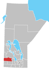
Location of the RM of Harrison Park in Manitoba
Coordinates: 50°27′50″N100°04′37″W / 50.464°N 100.077°W / 50.464; -100.077
CountryCanada
Province Manitoba
Incorporated
(amalgamated)
January 1, 2015 [1]
Area
  Total964.55 km2 (372.41 sq mi)
Population
 (2021) [2]
  Total1,852
  Density1.9/km2 (5.0/sq mi)
Time zone UTC-6 (CST)
  Summer (DST) UTC-5 (CDT)

The Municipality of Harrison Park is a rural municipality (RM) in the Canadian province of Manitoba that incorporated on January 1, 2015 via the amalgamation of the RMs of Harrison and Park. [1] It was formed as a requirement of The Municipal Amalgamations Act, which required that municipalities with a population less than 1,000 amalgamate with one or more neighbouring municipalities by 2015. [3] The Government of Manitoba initiated these amalgamations in order for municipalities to meet the 1997 minimum population requirement of 1,000 to incorporate a municipality. [4]

Contents

Harrison Park is located south of Riding Mountain National Park.
Demographics

In the 2021 Census of Population conducted by Statistics Canada, Harrison Park had a population of 1,852 living in 910 of its 1,769 total private dwellings, a change of

Related Research Articles

<span class="mw-page-title-main">Rural Municipality of Grey</span> Rural municipality in Manitoba, Canada

The Rural Municipality of Grey is a rural municipality in the Canadian province of Manitoba. It is named after Albert Grey, 4th Earl Grey, the former Governor General of Canada.

<span class="mw-page-title-main">Municipality of Brenda – Waskada</span> Rural municipality in Manitoba, Canada

The Municipality of Brenda – Waskada is a rural municipality (RM) in the Canadian province of Manitoba.

<span class="mw-page-title-main">Municipality of Deloraine – Winchester</span> Rural municipality in Manitoba, Canada

The Municipality of Deloraine – Winchester is a rural municipality (RM) in the Canadian province of Manitoba.

<span class="mw-page-title-main">Rural Municipality of Ellice – Archie</span> Rural municipality in Manitoba, Canada

The Rural Municipality of Ellice – Archie is a rural municipality (RM) in the Canadian province of Manitoba.

<span class="mw-page-title-main">Municipality of Glenboro – South Cypress</span> Rural municipality in Manitoba, Canada

The Municipality of Glenboro – South Cypress is a rural municipality (RM) in the Canadian province of Manitoba.

<span class="mw-page-title-main">Grandview Municipality</span> Rural municipality in Manitoba, Canada

Grandview Municipality is a rural municipality (RM) in the Parkland Region of Manitoba, Canada. It is located in a valley between Duck Mountain Provincial Forest & Park and Riding Mountain National Park, which both lie partially within the RM's territory.

<span class="mw-page-title-main">Hamiota Municipality</span> Incorporated municipality in Manitoba, Canada

Hamiota Municipality is an incorporated municipality in the Canadian province of Manitoba.

<span class="mw-page-title-main">Rural Municipality of Lakeshore</span> Rural municipality in Manitoba, Canada

The Rural Municipality of Lakeshore is a rural municipality (RM) in the Parkland Region of Manitoba, Canada.

<span class="mw-page-title-main">Municipality of Lorne</span> Rural municipality in Manitoba, Canada

The Municipality of Lorne is a rural municipality (RM) in the Canadian province of Manitoba.

<span class="mw-page-title-main">Municipality of Louise</span> Rural municipality in Manitoba, Canada

The Municipality of Louise is a rural municipality (RM) in the Canadian province of Manitoba.

<span class="mw-page-title-main">Municipality of McCreary</span> Rural municipality in Manitoba, Canada

The Municipality of McCreary is a rural municipality (RM) in the Parkland Region of Manitoba, Canada.

<span class="mw-page-title-main">Rural Municipality of Minto-Odanah</span> Rural municipality in Manitoba, Canada

The Rural Municipality of Minto-Odanah is a rural municipality (RM) in the Canadian province of Manitoba that incorporated on January 1, 2015 via the amalgamation of the RMs of Minto and Odanah. It was formed as a requirement of The Municipal Amalgamations Act, which required that municipalities with a population less than 1,000 amalgamate with one or more neighbouring municipalities by 2015. The Government of Manitoba initiated these amalgamations in order for municipalities to meet the 1997 minimum population requirement of 1,000 to incorporate a municipality.

<span class="mw-page-title-main">Municipality of North Cypress – Langford</span> Rural municipality in Manitoba, Canada

The Municipality of North Cypress – Langford is a rural municipality (RM) in the Canadian province of Manitoba. It is located northeast and east of the City of Brandon. The town of Neepawa borders the RM to the north. Canadian Forces Base Shilo is also adjacent to the RM.

<span class="mw-page-title-main">Rural Municipality of Oakview</span> Rural municipality in Manitoba, Canada

The Rural Municipality of Oakview is a rural municipality (RM) in the Canadian province of Manitoba, incorporated on January 1, 2015 as a result of the amalgamation of the rural municipalities of Blanshard, Saskatchewan, and the town of Rapid City. It was formed as a requirement of The Municipal Amalgamations Act, which required that municipalities with a population less than 1,000 amalgamate with one or more neighbouring municipalities by 2015. The Government of Manitoba initiated these amalgamations in order for municipalities to meet the 1997 minimum population requirement of 1,000 to incorporate a municipality.

<span class="mw-page-title-main">Municipality of Pembina</span> Rural municipality in Manitoba, Canada

The Municipality of Pembina is a rural municipality (RM) in the Canadian province of Manitoba.

<span class="mw-page-title-main">Municipality of Rhineland</span> Rural municipality in Manitoba, Canada

The Municipality of Rhineland is a rural municipality (RM) in the Canadian province of Manitoba. The RM had a population of 5,945 as of the 2016 Canada Census. The average age in the municipality is 31.

<span class="mw-page-title-main">Rural Municipality of Riding Mountain West</span> Rural municipality in Manitoba, Canada

The Rural Municipality of Riding Mountain West is a rural municipality (RM) in the Canadian province of Manitoba. It is located in Manitoba's Parkland region, between Riding Mountain National Park near the province's western border with Saskatchewan.

<span class="mw-page-title-main">Riverdale Municipality</span> Rural municipality in Manitoba, Canada

Riverdale Municipality is a rural municipality (RM) in the Canadian province of Manitoba.

<span class="mw-page-title-main">Rossburn Municipality</span> Rural municipality in Manitoba, Canada

Rossburn Municipality is a rural municipality (RM) in the Parkland Region of Manitoba, Canada.

<span class="mw-page-title-main">Rural Municipality of Yellowhead</span> Rural municipality in Manitoba, Canada

The Rural Municipality of Yellowhead is a rural municipality (RM) in the Canadian province of Manitoba.

References

  1. 1 2 "The Municipal Amalgamations Act (C.C.S.M. c. M235): Rural Municipality of Harrison and Rural Municipality of Park Amalgamation Regulation" (PDF). Government of Manitoba. Retrieved October 4, 2014.
  2. "Census Profile, 2021 Census of Population". Statistics Canada . Retrieved March 29, 2023.
  3. "The Municipal Amalgamations Act (C.C.S.M. c. M235)". Government of Manitoba. October 2, 2014. Retrieved October 4, 2014.
  4. "Speech from the Throne: At the Opening of the Second Session of the 40th Legislature of the Province of Manitoba". Government of Manitoba. November 19, 2012. Retrieved October 4, 2014.
  5. "Population and dwelling counts: Canada, provinces and territories, and census subdivisions (municipalities), Manitoba". Statistics Canada. February 9, 2022. Retrieved February 20, 2022.