Shoal Lake, Manitoba

Last updated

Shoal Lake
Canada Manitoba location map 2.svg
Red pog.svg
Shoal Lake
Coordinates: 50°26′16″N100°35′28″W / 50.43778°N 100.59111°W / 50.43778; -100.59111
CountryFlag of Canada (Pantone).svg  Canada
ProvinceFlag of Manitoba.svg  Manitoba
Rural municipality Rural Municipality of Yellowhead
Incorporated (village) [1] January 12, 1909
Incorporated (town) [1] October 10, 1997
Amalgamated [1] January 1, 2011
Government
  Federal riding Brandon—Souris
  Prov. riding Riding Mountain
Area
[2]
  Total2.58 km2 (1.00 sq mi)
Population
 (2011) [2]
  Total714
  Density276.9/km2 (717/sq mi)
Time zone UTC-6 (CST)
  Summer (DST) UTC-5 (CDT)
Postal Code
R0J
Area code 204
Website www.shoallake.ca

Shoal Lake is a locality in the southwest of Manitoba, Canada. Originally incorporated as a town, Shoal Lake amalgamated with the Rural Municipality of Shoal Lake on January 1, 2011 to form the Municipality of Shoal Lake, which became the Rural Municipality of Yellowhead on January 1, 2015. [1] [3] [4]

Contents

History

Shoal Lake was first settled in 1875 when the North-West Mounted Police established a barracks along the Carlton Trail at the south end of the lake. The community was established in 1884, and moved to its current location at the lake's north side in 1885 to coincide with the building of the Manitoba & Northwestern Railroad (now CPR). [5] The community incorporated as a village on January 12, 1909, and then changed to town status on October 10, 1997. [1] It amalgamated with the Rural Municipality of Shoal Lake on January 1, 2011, [1] which combined further with the Rural Municipality of Strathclair on January 1, 2015 to form the Rural Municipality of Yellowhead. [4]

Geography

The community lies to the northeast of a lake of the same name. With a length of 9 km (5.6 mi) and a stock of walleye and northern pike, the lake is a destination for boating and fishing. [6] The lake appears on the Palliser map of 1865. [7]

Climate

Climate data for Strathclair (15 km east)
MonthJanFebMarAprMayJunJulAugSepOctNovDecYear
Record high °C (°F)5
(41)
11
(52)
16.5
(61.7)
33.9
(93.0)
36.7
(98.1)
38.3
(100.9)
35
(95)
38
(100)
36.7
(98.1)
31
(88)
19.4
(66.9)
8
(46)
38.3
(100.9)
Mean daily maximum °C (°F)−11.7
(10.9)
−8.7
(16.3)
−1.9
(28.6)
9
(48)
16.8
(62.2)
21.2
(70.2)
23.7
(74.7)
23.5
(74.3)
17.4
(63.3)
9
(48)
−2.1
(28.2)
−9.4
(15.1)
7.2
(45.0)
Daily mean °C (°F)−17.1
(1.2)
−14.2
(6.4)
−7.1
(19.2)
2.9
(37.2)
10.2
(50.4)
15.3
(59.5)
17.7
(63.9)
16.8
(62.2)
10.9
(51.6)
3.3
(37.9)
−6.7
(19.9)
−14.3
(6.3)
1.5
(34.7)
Mean daily minimum °C (°F)−22.5
(−8.5)
−19.6
(−3.3)
−12.3
(9.9)
−3.2
(26.2)
3.6
(38.5)
9.3
(48.7)
11.6
(52.9)
10
(50)
4.4
(39.9)
−2.4
(27.7)
−11.2
(11.8)
−19.3
(−2.7)
−4.3
(24.3)
Record low °C (°F)−45
(−49)
−44
(−47)
−38.5
(−37.3)
−25.6
(−14.1)
−15
(5)
−3.3
(26.1)
−1.1
(30.0)
−4
(25)
−10
(14)
−22
(−8)
−36
(−33)
−43
(−45)
−45
(−49)
Average precipitation mm (inches)21.6
(0.85)
16.8
(0.66)
22.4
(0.88)
26.4
(1.04)
43.4
(1.71)
76.2
(3.00)
71.6
(2.82)
62.6
(2.46)
46.3
(1.82)
29
(1.1)
19
(0.7)
21.9
(0.86)
457.1
(18.00)
Source: Environment Canada (normals and extremes from 1981-2010) [8]

Demographics

In the 2021 Census of Population conducted by Statistics Canada, Shoal Lake had a population of 652 living in 307 of its 342 total private dwellings, a change of

Attractions

The community has a nine-hole golf course and hosts facilities for baseball, ice hockey, curling, and pickle-ball. It is home to the province's official museum to the North-West Mounted Police, which was built in 1984 to replicate barracks established at the south end of the lake in 1875. [10]

Infrastructure

Shoal Lake is located at the junction of highways 16, 21, and 42. It is serviced by the Shoal Lake Airport and Shoal Lake Water Aerodrome and by the Greyhound bus service (freight only). [11]

Notable residents

Related Research Articles

<span class="mw-page-title-main">Riverton, Manitoba</span> Place in Manitoba, Canada

Riverton is an unincorporated urban community in the Municipality of Bifrost-Riverton within the Canadian province of Manitoba.

<span class="mw-page-title-main">Rural Municipality of Sifton</span> Rural municipality in Manitoba, Canada

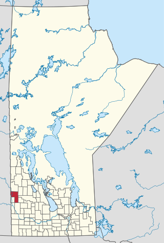
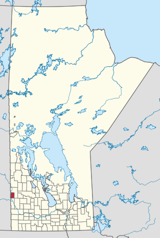
The Rural Municipality of Sifton is a rural municipality (RM) in the south-west portion of the Canadian province of Manitoba.

<span class="mw-page-title-main">Rural Municipality of Woodlands</span> Rural municipality in Manitoba, Canada

Woodlands is a rural municipality (RM) in the province of Manitoba in Western Canada. It lies in the southern part of the Interlake and is named for the community of Woodlands, which itself is named for the wooded lands of the area.

<span class="mw-page-title-main">Rural Municipality of Mossey River</span> Rural municipality in Manitoba, Canada

The Rural Municipality of Mossey River is a rural municipality (RM) in the Parkland Region of Manitoba, Canada, located at the south end of Lake Winnipegosis.

The Municipality of Shoal Lake is a former rural municipality (RM) in the Canadian province of Manitoba. It was originally incorporated as a rural municipality on January 1, 2011. It ceased on January 1, 2015, as a result of its provincially mandated amalgamation with the RM of Strathclair to form the Rural Municipality of Yellowhead.

<span class="mw-page-title-main">Municipality of Killarney-Turtle Mountain</span> Rural municipality in Manitoba, Canada

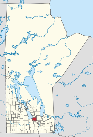
Killarney-Turtle Mountain is a rural municipality (RM) located in the Westman Region of Manitoba, Canada. It is located to the immediate north of the Canada–United States border opposite Rollete and Towner Counties, North Dakota.

<span class="mw-page-title-main">Municipality of Bifrost-Riverton</span> Rural municipality in Manitoba, Canada

The Municipality of Bifrost-Riverton is a rural municipality (RM) in the Canadian province of Manitoba, and is one of the northernmost rural municipalities in the Interlake Region.

<span class="mw-page-title-main">Rural Municipality of Ellice-Archie</span> Rural municipality in Manitoba, Canada

The Rural Municipality of Ellice-Archie is a rural municipality (RM) in the Canadian province of Manitoba.

<span class="mw-page-title-main">Municipality of Glenella-Lansdowne</span> Rural municipality in Manitoba, Canada

The Municipality of Glenella – Lansdowne is a rural municipality (RM) in the Canadian province of Manitoba.

<span class="mw-page-title-main">Municipality of Grassland</span> Rural municipality in Manitoba, Canada

The Municipality of Grassland is a rural municipality (RM) in the Canadian province of Manitoba.

<span class="mw-page-title-main">Rural Municipality of Lakeshore</span> Rural municipality in Manitoba, Canada

The Rural Municipality of Lakeshore is a rural municipality (RM) in the Parkland Region of Manitoba, Canada.

<span class="mw-page-title-main">Rural Municipality of Riding Mountain West</span> Rural municipality in Manitoba, Canada

The Rural Municipality of Riding Mountain West is a rural municipality (RM) in the Canadian province of Manitoba. It is located in Manitoba's Parkland region, between Riding Mountain National Park near the province's western border with Saskatchewan.

<span class="mw-page-title-main">Riverdale Municipality</span> Rural municipality in Manitoba, Canada

Riverdale Municipality is a rural municipality (RM) in the Canadian province of Manitoba.

<span class="mw-page-title-main">Rossburn Municipality</span> Rural municipality in Manitoba, Canada

Rossburn Municipality is a rural municipality (RM) in the Parkland Region of Manitoba, Canada.

<span class="mw-page-title-main">Municipality of Russell-Binscarth</span> Rural municipality in Manitoba, Canada

The Municipality of Russell – Binscarth is a rural municipality (RM) in the Parkland Region of Manitoba, Canada. It is located in the far western part of the province and shares a border with the neighbouring province of Saskatchewan.

<span class="mw-page-title-main">Municipality of Two Borders</span> Rural municipality in Manitoba, Canada

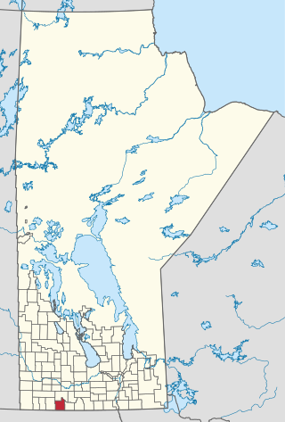
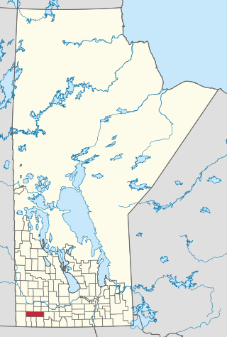
The Municipality of Two Borders is a rural municipality (RM) in the Canadian province of Manitoba. It is located in the extreme south-west corner of the province in the Westman Region.

<span class="mw-page-title-main">Rural Municipality of Yellowhead</span> Rural municipality in Manitoba, Canada

The Rural Municipality of Yellowhead is a rural municipality (RM) in the Canadian province of Manitoba.

References

  1. 1 2 3 4 5 6 "Manitoba Municipalities: Shoal Lake". The Manitoba Historical Society. April 11, 2014. Retrieved July 15, 2014.
  2. 1 2 "Census Profile: Shoal Lake, T, Manitoba (Dissolved census subdivision)". 2011 Census of Population . Statistics Canada. April 28, 2014. Retrieved July 15, 2014.
  3. "Town of Shoal Lake and the Rural Municipality of Shoal Lake Amalgamation Regulation" (PDF). www.gov.mb.ca. The Queen's Printer for the Province of Manitoba. June 15, 2010. Retrieved July 15, 2014.
  4. 1 2 "Manitoba's Municipal History: Municipal Amalgamations (2015)". The Manitoba Historical Society. December 1, 2014. Retrieved January 2, 2015.
  5. Dickie, Reid. "Shoal Lake History". WordPress. Retrieved July 15, 2014.
  6. "Shoal Lake Municipal Authority: Rural Municipality of Shoal Lake Crown Lands – Existing Subdivision". www.gov.mb.ca. Retrieved July 15, 2014.
  7. Hamilton, William (1978). The Macmillan Book of Canadian Place Names. Toronto: Macmillan. p. 64. ISBN   0-7715-9754-1.
  8. Environment Canada Canadian Climate Normals 1971–2000, accessed July 15, 2014
  9. "Population and dwelling counts: Canada and designated places". Statistics Canada. February 9, 2022. Retrieved September 3, 2022.
  10. "Shoal Lake Visitor Information" . Retrieved July 15, 2014.
  11. "Greyhound.ca Station Locator". Greyhound.ca. Retrieved July 16, 2014. Search "R0J1Z0" or "Shoal Lake, Manitoba"