Campgaw Mountain is the northernmost ridge of the volcanically formed Watchung Mountains, along the border of Franklin Lakes, Oakland, and Mahwah in Bergen County, New Jersey, United States. Located almost entirely within the bounds of Campgaw Mountain Reservation, the mountain offers numerous outdoor recreational opportunities, including the only ski slope in the Watchungs. Campgaw Mountain is commonly considered to be part of the greater Ramapo Mountains region, but the flora and geology of the mountain is quite different from the surrounding area and more closely resembles the nearby Preakness Range to the south.
Liberty Corner is an unincorporated community located in Bernards Township, in Somerset County, New Jersey, United States. Liberty Corner is about 3.75 miles (6 km) south of Bernardsville. Liberty Corner has a post office with ZIP code 07938. The Liberty Corner Historic District was listed on the state and national registers of historic places in 1991.
Hancock's Bridge is an unincorporated community and census-designated place (CDP) located within Lower Alloways Creek Township, in Salem County, New Jersey, United States. As of the 2010 United States Census, the CDP's population was 254. The area is served as United States Postal Service ZIP code 08038.
Curries Woods is a neighborhood in the southern part of Greenville in Jersey City, New Jersey bordering Bayonne. It was named after James Curie, who was on the town Committee for Greenville when it was its own Township in the 19th century. The area remained rural until the later part of the century when the Central Railroad of New Jersey built a line connecting ferries to Elizabeth, New Jersey and New York City. Currie's Woods still remained untouched through the late part of the century and it was valued for its woods, rocky shore and dunes on Newark Bay. A lot of the land was eventually lost, but a tract was set aside in the early part of the 20th century. A small cemetery, the Old Greenville Cemetery, was nearby. This park lost much of its land to the city's largest Housing Authority project in 1959, except a small tract in Bayonne, Mercer Park.
The English Neighborhood was the colonial-era name for the towns in eastern Bergen County, New Jersey, along the Hudson Palisades between the Hudson River and the Hackensack River, particularly around its main tributary, Overpeck Creek. The region had been part of the Dutch New Netherland colony of Bergen, whose main town was located at Bergen Square in today's Jersey City. The name speaks to the geography of the region, bergen being the Dutch word for hills. Earlier attempts at settlement at Achter Col and Vriessendael had been compromised in conflicts with the precolonial population, bands of the Lenape known by their exonyms, the Hackensack and the Tappan.
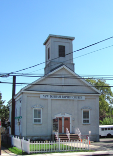
New Durham is an unincorporated community and neighborhood located within North Bergen Township in Hudson County, New Jersey, United States. It is located near the foot of Union Turnpike and Bergen Turnpike, and south of the Tonnelle Avenue Station of the Hudson Bergen Light Rail. It is one of the few residential areas along the otherwise industrial/commercial Tonnelle Ave, and site of one of the town's main post offices.

The Preakness Range is a range of the trap rock Watchung Mountains on the western edge of the Newark Basin in northern New Jersey. A large portion of this range is included in High Mountain Park Preserve, offering miles of hiking trails with vistas overlooking New Jersey and New York City. The peaks of the Preakness Range, the highest of the Watchung Mountains, shelter endangered ecosystems, including perched wetlands and rare trap rock glade communities.

The Feltville Formation is a mapped bedrock unit primarily in New Jersey, with one known outlier in Pennsylvania and another one in New York. It is named for the Deserted Village of Feltville in Watchung Reservation, New Jersey, which is near where its type section was described by paleontologist Paul E. Olsen.
Bonhamtown is a section of Edison Township in Middlesex County, New Jersey, United States.

Black Brook is a tributary of the Passaic River that flows through the Great Swamp National Wildlife Refuge in Morris County, New Jersey, in the United States. Black Brook rises at the north east base of Long Hill, Chatham Township, Morris County, flows westerly along the hill, by a course of 7 or 8 miles to its recipient in Morris Township, New Jersey. Due to the chemical fertilizer usage in nearby areas, Black Brook has the second worst water quality after Loantaka Brook.

Chews Landing is an unincorporated community within Gloucester Township, in Camden County, New Jersey, United States.

Squankum is an unincorporated community located within Howell Township in Monmouth County, New Jersey, United States. The name Squankum was used for a town in Gloucester County, which was changed to present day Williamstown, due to postal regulations that prohibited the two towns from having the same name.

Hornerstown is an unincorporated community located within Upper Freehold Township in Monmouth County, New Jersey, United States. Hornerstown is located near Cream Ridge and uses the 08514 ZIP code.

Bargaintown is an unincorporated community located within Egg Harbor Township, in Atlantic County, New Jersey, United States. The Egg Harbor Township municipal building is located in Bargaintown, about 0.25 mi (0.40 km) east of the Garden State Parkway.
Allamuchy Mountain is a mountain in Sussex and Warren Counties, New Jersey. The major peak rises to 1,222 feet (372 m), and is located in Byram Township. The mountain also covers portions of Allamuchy Township in Warren County and Green Township in Sussex County. It overlooks the Musconetcong River to the southeast, and forms part of the divide between that river and the Pequest to the northwest. It is part of the New York–New Jersey Highlands of the Reading Prong.

Jenny Jump Mountain is a mountain in Warren County, New Jersey. The summit rises to 1,129 feet (344 m); the mountain is within Frelinghuysen, Hope, Independence and Liberty Townships. It is part of the New York–New Jersey Highlands of the Appalachian Mountains, although somewhat isolated to the west of the main body of the Highlands.
Scotts Mountain is a mountain in Warren County, New Jersey. The mountain covers portions of Harmony, Lopatcong, Franklin and Washington Townships; the main summit rises to 1,086 feet (331 m), and is located in Harmony. It is part of the New York–New Jersey Highlands of the Appalachian Mountains, although somewhat isolated to the west of the main body of the Highlands.

Penton is an unincorporated community located within Alloway Township in Salem County, New Jersey, United States. The community is the site of the historic Penton Chapel.

Piscatawaytown is the oldest neighborhood in Edison Township in Middlesex County, New Jersey. It was established in the 1660s as the original village in what was then within Piscataway Township. Piscatawaytown is centered around St. James Church and the Piscatawaytown Common, near the intersection of Plainfield and Woodbridge Avenues.