
Presidential Lakes Estates is an unincorporated community and census-designated place (CDP) located within Pemberton Township, in Burlington County, in the U.S. state of New Jersey. As of the 2010 United States Census, the CDP's population was 2,365.
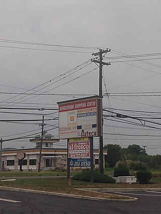
Ramblewood is an unincorporated community and census-designated place (CDP) located within Mount Laurel Township in Burlington County, in the U.S. state of New Jersey. As of the 2010 United States Census, the CDP's population was 5,907.

Greentree is an unincorporated community and census-designated place (CDP) located within Cherry Hill Township, in Camden County, in the U.S. state of New Jersey. As of the 2010 United States Census, the CDP's population was 11,367.

Springdale is an unincorporated community and census-designated place (CDP) located within Cherry Hill Township, in Camden County, in the U.S. state of New Jersey. As of the 2010 United States Census, the section population was 14,518.

Beckett is an unincorporated community and census-designated place (CDP) within Logan Township, in Gloucester County, in the U.S. state of New Jersey. As of the 2010 United States Census, the CDP's population was 4,847.

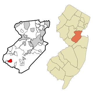
Concordia is an unincorporated community and census-designated place (CDP) located within Monroe Township, in Middlesex County, in the U.S. state of New Jersey. The CDP is oriented around the age restricted gated community of Concordia. As of the 2010 United States Census, the CDP's population was 3,092.

Old Bridge is a census-designated place (CDP) in Old Bridge Township, in Middlesex County, in the U.S. state of New Jersey. As of the 2010 United States Census, the CDP's population was 23,753. Despite the similarity in the name of the CDP and the township, the two are not one and the same, as had been the case for most paired Township / CDP combinations prior to the 2010 Census, in which the CDP was coextensive with a township of the same name.

Plainsboro Center is an unincorporated community and census-designated place (CDP) located within Plainsboro Township, in Middlesex County, in the U.S. state of New Jersey. As of the 2010 United States Census, the CDP's population was 2,712.
Princeton Meadows is an unincorporated community and census-designated place (CDP) located within Plainsboro Township, in Middlesex County, in the U.S. state of New Jersey. As of the 2010 United States Census, the CDP's population was 13,834.

Woodbridge is an unincorporated community and census-designated place (CDP) within Woodbridge Township, in Middlesex County, in the U.S. state of New Jersey. As of the 2010 United States Census, the CDP's population was 19,265. Despite the similarity in the name of the CDP and the township, the two are not coextensive; the CDP occupies 15.7% of the township's 24.51 square miles (63.5 km2).

East Freehold is an unincorporated community and census-designated place (CDP) located within Freehold Township, in Monmouth County, in the U.S. state of New Jersey. As of the 2010 United States Census, the CDP's population was 4,894.

Morganville is an unincorporated community and census-designated place (CDP) within Marlboro Township, in Monmouth County, New Jersey. As of the 2010 United States Census, the CDP's population was 5,040.

Shark River Hills is an unincorporated community and census-designated place (CDP) within Neptune Township, in Monmouth County, in the U.S. state of New Jersey. As of the 2010 United States Census, the CDP's population was 3,697.

Yorketown is an unincorporated community and census-designated place (CDP) within Manalapan Township, in Monmouth County, in the U.S. state of New Jersey. At the 2020 census, the CDP's population was 6,739.

White Meadow Lake is an unincorporated community and census-designated place (CDP) located within Rockaway Township, in Morris County, in the U.S. state of New Jersey. As of the 2010 United States Census, the CDP's population was 8,836.

Leisure Village East is an unincorporated community and census-designated place (CDP) located within Lakewood Township, in Ocean County, in the U.S. state of New Jersey. As of the 2010 United States Census, the CDP's population was 4,217. Leisure Village East is one of several active adult communities bearing similar names. Leisure Village and Leisure Village West are the other two communities nearby.
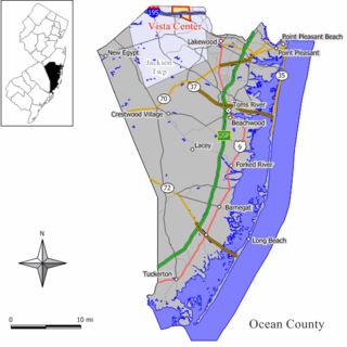
Vista Center is an unincorporated community and census-designated place (CDP) located within Jackson Township in Ocean County, in the U.S. state of New Jersey. As of the 2010 United States Census, the CDP's population was 3,689.

Crandon Lakes is an unincorporated community and census-designated place (CDP) split between Hampton Township and Stillwater Township, in Sussex County, in the U.S. state of New Jersey. As of the 2010 United States Census, the CDP's population was 1,178, of which 682 were in Hampton Township and 496 in Stillwater Township.

Ramtown is a census-designated place and unincorporated community located within Howell Township, in Monmouth County, in the U.S. state of New Jersey. As of the 2010 United States Census, the CDP's population was 6,242.

Elwood is an unincorporated community and census-designated place (CDP) located within Mullica Township in Atlantic County, in the U.S. state of New Jersey. As of the 2010 United States Census, the CDP's population was 1,437. At previous censuses, the area was listed by the U.S. Census Bureau as the Elwood-Magnolia CDP. The area is served as United States Postal Service ZIP Code 08217.


