
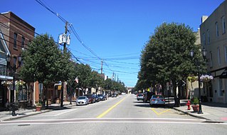
Route 27 is a state highway in New Jersey, United States. It runs 38.53 mi (62.01 km) from U.S. Route 206 (US 206) in Princeton, Mercer County northeast to an interchange with Route 21 and Broad Street in Newark, Essex County. The route passes through many communities along the way, including New Brunswick, Highland Park, Edison, Metuchen, Rahway, and Elizabeth. Route 27 is a two- to four-lane undivided highway for most of its length, passing through a variety of urban and suburban environments. It intersects many roads along the way, including Route 18 in New Brunswick, Interstate 287 (I-287) in Edison, the Garden State Parkway in Woodbridge Township, Route 35 in Rahway, Route 28 in Elizabeth, and U.S. Route 22 in Newark. Route 27 crosses the Raritan River on the Albany Street Bridge, which connects Highland Park on the east with New Brunswick on the west.

Route 35 is a state highway in the U.S. state of New Jersey, primarily traveling through the easternmost parts of Middlesex, Monmouth, and Ocean counties. It runs 58.11 mi (93.52 km) from the entrance to Island Beach State Park in Berkeley Township, Ocean County to an intersection with Route 27 in Rahway, Union County. Between Seaside Park and Mantoloking, Route 35 follows the right-of-way of the former Pennsylvania Railroad along the Jersey Shore. The route heads through Point Pleasant Beach and crosses the Manasquan River on the Brielle Bridge, meeting Route 34 and Route 70 at the former Brielle Circle in Wall Township. From there, Route 35 heads north and intersects Route 138, an extension of Interstate 195, continuing north through Monmouth County before crossing the Victory Bridge over the Raritan River into Perth Amboy, has where the route continues north to Rahway.

Middlesex County is located in central New Jersey, United States, extending inland from the Raritan Valley region to the northern portion of the Jersey Shore. As of the 2020 United States census, the county was the state's third-most populous county with a population of 863,162, its highest decennial count ever and an increase of 53,304 (+6.6%) from the 2010 census count of 809,858, which in turn reflected an increase of 4,725 (0.9%) from the 750,162 counted in the 2000 census. Middlesex is part of the New York metropolitan area. Many communities within the county serve as commuter towns to and from New York City and other points north.

Perth Amboy is a city in Middlesex County, in the U.S. state of New Jersey. Perth Amboy is part of the New York metropolitan area. As of the 2020 United States census, the city's population was 55,436, an increase of 4,622 (+9.1%) from the 2010 census count of 50,814, which in turn reflected an increase of 3,511 (+7.4%) from the 47,303 counted in the 2000 census. Perth Amboy has a Hispanic majority population. In the 2010 census, the Hispanic population made up 78.1% of the population, the second-highest in the state, behind Union City at 84.7%. Perth Amboy is known as the "City by the Bay", referring to its location adjoining Raritan Bay. The Census Bureau's Population Estimates Program calculated that the city's population was 55,357 in 2021, ranking the city as the 725th-most-populous in the country.

Sayreville is a borough in Middlesex County, in the U.S. state of New Jersey. Sayreville is within the heart of the Raritan Valley region, located on the south banks of the Raritan River, and also located on the Raritan Bay. As of the 2020 United States census, the borough's population was 45,345, an increase of 2,641 (+6.2%) from the 2010 census count of 42,704, which in turn reflected an increase of 2,327 (+5.8%) from the 40,377 counted in the 2000 census.
South Amboy is a suburban city in Middlesex County, in the U.S. state of New Jersey, located on Raritan Bay. As of the 2020 United States census, the city's population was 9,411, an increase of 780 (+9.0%) from the 2010 census count of 8,631, which in turn reflected an increase of 718 (+9.1%) from the 7,913 counted in the 2000 census.

Raritan River is a major river of New Jersey. Its watershed drains much of the mountainous area of the central part of the state, emptying into the Raritan Bay on the Atlantic Ocean.

North Brunswick is a township in Middlesex County, in the U.S. state of New Jersey. It is centrally located in the Raritan Valley region within the New York metropolitan area. As of the 2020 United States census, the township's population was 43,905, an increase of 3,163 (+7.8%) from the 2010 census count of 40,742, which in turn reflected an increase of 3,455 (+12.3%) from the 36,287 counted in the 2000 census.
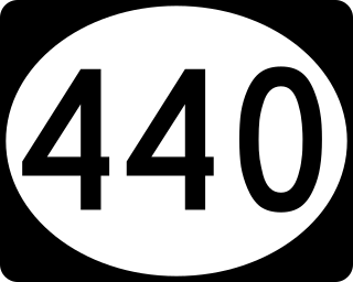
Route 440 is a state highway in New Jersey, United States. It comprises two segments, a 5.15-mile (8.29 km) freeway in Middlesex County linking Interstate 287 (I-287) and the New Jersey Turnpike (I-95), in Edison to the Outerbridge Crossing in Perth Amboy and a 8.18-mile (13.16 km) four-lane divided highway in Hudson County running from the Bayonne Bridge in Bayonne to U.S. Route 1/9 Truck in Jersey City. These two segments are connected by New York State Route 440 (NY 440), which runs across Staten Island. The freeway portion in Middlesex County is six lanes wide and interchanges with the Garden State Parkway and US 9 in Woodbridge.

Route 184 is a state highway in New Jersey, United States. It is an old section of Route 440 that was rerouted. Route 184's western end is at an intersection with the Garden State Parkway in Woodbridge Township; its eastern end is at an intersection with Route 35 in Perth Amboy. The highway passes several local landmarks along the highway, but is less populated than the surrounding area. Except for the easternmost section between Route 35 and Route 440, the highway is concurrent with County Route 501, but is not county-maintained.

The Newark–Trenton Fast Line was an interurban line from Newark, New Jersey to Trenton, New Jersey via Elizabeth and New Brunswick. It was owned and operated by the Public Service Railroad, a subsidiary of the Public Service Corporation of New Jersey.

Keasbey is a census-designated place (CDP) and unincorporated community located within Woodbridge Township, in Middlesex County, in the U.S. state of New Jersey. It is located in the western outskirts of adjacent Perth Amboy. As of the 2020 census, the CDP's population was 3,027. Many Hispanic / Latino families have relocated from Perth Amboy to Keasbey.

Louis Creekmur was an American professional football player who was an offensive lineman for 10 years (1950–1959) with the Detroit Lions of the National Football League (NFL). He was inducted into the Pro Football Hall of Fame in 1996.
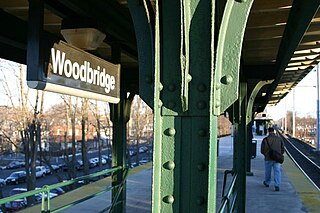
Woodbridge is a commuter railroad station in Woodbridge Township, Middlesex County, New Jersey, United States. Located on NJ Transit's North Jersey Coast Line, it is one of three active railroad stations in the eponymous township, including Avenel to the north on the same line and Metropark station on the Northeast Corridor Line. Woodbridge station is located on Pearl Street at the intersection with Brook Street, where stairs to the single island platform that serves trains are located.
The Middlesex County Magnet Schools, formerly known as the Middlesex County Vocational and Technical Schools, is a public school district that provides a network of high schools serving the vocational and technical education needs of students in Middlesex County, New Jersey, United States. The district was the first county vocational school system in the United States. The district serves high school, adult, and special needs students.
The Perth Amboy and Woodbridge Railroad was a railroad company in the state of New Jersey. It was incorporated in 1855, and completed its line between Rahway and Perth Amboy, New Jersey, in 1864. The company became part of the Pennsylvania Railroad system and was merged into the United New Jersey Railroad and Canal Company in 1958. Its line is part of the New Jersey Transit's North Jersey Coast Line.
Perth Amboy, New Jersey is located at the mouth of the Raritan River and the Arthur Kill at the Raritan Bay, and is part of the region known as the Raritan Bayshore.
The Middlesex Greenway is a 3.5 miles (5.6 km) rail trail in New Jersey Metuchen, Edison and Woodbridge. It is part of the Middlesex County Park System. It makes up a portion of the East Coast Greenway.


