
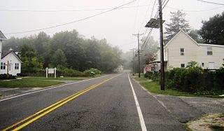
Applegarth is an unincorporated community located within Monroe Township in Middlesex County, in the U.S. state of New Jersey. The settlement is located in the southern portion of the township and is traversed by the road of the same name, Applegarth Road. At the location of the original settlement, at the intersection of Applegarth, Wycoffs Mills, and Old Church Roads, there is a restaurant, farmland, and the Applegarth Fire Department. Further north along Applegarth Road are housing developments, age-restricted communities, and two elementary schools: Applegarth and Oak Tree.
Buddtown is an unincorporated community located within Southampton Township in Burlington County, in the U.S. state of New Jersey. Located between Vincentown and Pemberton, it is named for Thomas Budd who owned farmland in the area in the 18th century. The area itself contains houses and churches in the community itself and farmland surrounding the settlement. The stream that runs through Buddtown is named Stop the Jade Run supposedly named for the cry made by the owners of a runaway horse, "jade" being an old name for a horse.
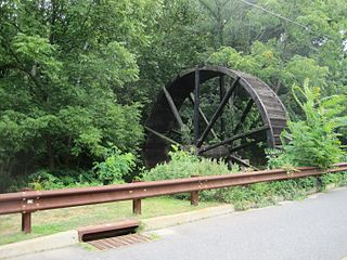
Bucks Mill is an unincorporated community located within Colts Neck Township, in Monmouth County, in the U.S. state of New Jersey. Bucks Mill Road is the main road that passes north and south through the area; County Route 537 travels to the south of Bucks Mill, near the Hominy Hill Golf Course. Homes, equestrian facility and horse farms, and the township-owned Bucks Mill Recreational Area are located in the area. The settlement is named for Bucks Mill, a gristmill that derived its power from a watermill on the Yellow Brook. Originally built in 1854 and owned for many years by William Buck, Alfred Buck, and Garrett Buck, it was destroyed by a fire on October 30, 1967. The watermill is the only remaining artifact of the original complex and stands today on the side of Bucks Mill Road.

New Canton is an unincorporated community located along the border of Robbinsville Township in Mercer County and Upper Freehold Township in Monmouth County, in the U.S. state of New Jersey. The area was once known as Cabbagetown and has been settled since the 18th century. The settlement is located at the intersection of Old York Road and New Canton-Stone Tavern Road just north of Interstate 195's interchange 8. The Upper Freehold side of the area contains farmland and new housing developments while the Robbinsville side features new commercial warehouse buildings including an Amazon.com Fulfillment Center opened in July 2014.

Rockefellows Mills is an unincorporated community located within Raritan Township in Hunterdon County, in the U.S. state of New Jersey. The settlement is located along the South Branch Raritan River near Three Bridges. The river is spanned in the area by the historic Rockafellows Mill Bridge built in 1900 and part of the Raritan–Readington South Branch Historic District. Most of the area within the Raritan Township side of the river is forested however on the north side of the river in Readington Township, some farmland dots the area.

Sandy Ridge is an unincorporated community located within Delaware Township in Hunterdon County, in the U.S. state of New Jersey. As its name implies, the community is located at the top of a small hill that is sandwiched between the Hunterdon Plateau and the Sourland Mountains. Sandy Ridge Road is the main road east and west through the community while County Route 605 is a minor arterial road that passes north and south through the area. CR 605 enters from the south on Sandy Ridge-Mt. Airy Road, jogs to the west on Sandy Ridge Road for 0.04 miles (64 m), and exits to the north on Cemetery Road towards CR 523. The area consists of mainly residences with some farmland and forestland. The Sandy Ridge Church is a Baptist church founded in 1818 with its current building constructed in 1866 and is located in the center of Sandy Ridge.

Cottrell Corners is an unincorporated community located within Old Bridge Township in Middlesex County, in the U.S. state of New Jersey. Located at the corner of Old Bridge-Matawan Road and Cottrell Road, the area is named for the Cottrell Family who owned an apple farm at the crossroads since before the United States was founded. Though the last parcel of the farmland had originally been sold to a developer in 2002, the Middlesex County Freeholder Board purchased the property and intends to preserve it. In addition to the farm, the area contains stores, a townhouse development, and is the seat of the Old Bridge municipal offices and library.

Fresh Ponds is an unincorporated community located within South Brunswick Township in Middlesex County, in the U.S. state of New Jersey. It is located in a rural portion of the township at the intersection of Fresh Ponds Road and Davidson Mill Road. Forest land, farms, homes, and a church are located around the settlement.
Gravel Hill or Gravelhill is an unincorporated community located within Monroe Township in Middlesex County, in the U.S. state of New Jersey. Located in a rural part of Monroe Township, the area is made up of approximately half farmland and half forestland. Homes line the roads that run through the area.

Middlesex Downs is an unincorporated community located within Monroe Township in Middlesex County, in the U.S. state of New Jersey. The wholly residential settlement contains small homes along Dey Grove Road and Bergen Mills Road with larger homes in developments towards the south. The township-owned James Monroe Memorial Park is also located in this settlement. Much of the area to the north of Dey Grove Road consists of forest land but at one time this was planned to become a large planned community arranged in a street grid. The small property parcels and paper streets remain on township tax maps today.

Schalks or Schalks Station is an unincorporated community located within Plainsboro Township in Middlesex County, in the U.S. state of New Jersey. Located along Schalks Crossing Road at its junction with the Northeast Corridor railroad tracks, the area contains single-family homes, forested areas, a former research nuclear reactor built by Industrial Reactor Laboratories, and the rear yards to offices within the Princeton Forrestal Center.
Ardena is an unincorporated community located within Howell Township in Monmouth County, in the U.S. state of New Jersey. The community is located along County Route 524 near Vanderveer Road in the western part of the township. The area consists of about half farmland and half residential developments.

Cooleys Corner is an unincorporated community located within Upper Freehold Township in Monmouth County, in the U.S. state of New Jersey. The site of the settlement is within the Assunpink Wildlife Management Area, a New Jersey Department of Environmental Protection Division of Fish and Wildlife-operated preserved area in Monmouth and Mercer counties along the Assunpink Creek. Before the creation of the Assunpink Lake in the 1970s, the area consisted of farmland located at the intersection of Clarksburg Road and Imlaystown-Hightstown Road. Some farmland is still present in the area but is now mostly used by hunters. The main boat ramp to Assunpink Lake is located along the former Imlaystown-Hightstown Road.

Ely is an unincorporated community located within Millstone Township in Monmouth County, in the U.S. state of New Jersey. The settlement is named for the Ely family that owned property in the area and operated the Charleston Springs hotel. Today, the settlement is located along Stage Coach Road, County Route 524, in the eastern portion of the township. Most of the area consists of large single-family homes though some farmland and the township-owned Brandywine Soccer Complex are located in the near the settlement.

Lower Squankum is an unincorporated community located within Howell Township in Monmouth County, in the U.S. state of New Jersey. The settlement is located along Lakewood-Farmingdale Road at its intersection with Herbertsville Road and Old Tavern Road in the eastern side of the township. It is also located near the boundary of Allaire State Park and is south of Interstate 195's exit 31. Nearby the community are the remains of the Lower Squankum Mill and the Lower Squankum Friends Burial Site, located within the median of CR 547 at the aforementioned interchange.

Red Valley is an unincorporated community located within Upper Freehold Township in Monmouth County, in the U.S. state of New Jersey. The settlement is located at the intersection of County Route 526 and Red Valley Road (south) and Yellow Meetinghouse Road (north) near the township's eastern border with Millstone Township. Except for some single-family houses located along the roads in the area, the area is primarily made up of farmland.

Old Church is an unincorporated community located within Monroe Township in Middlesex County, in the U.S. state of New Jersey. The settlement is named for a Presbyterian community that settled on the site but relocated to Cranbury c. 1740. Originally, the area was farmland. One of the farms in the area was the Dey Farm, in existence since the founding of Monroe Township in 1838 and the site of a command post used by George Washington during the Battle of Monmouth in 1778. Starting in 2004, the area experienced a major change from its agricultural roots to single-family residences on the south side of the area and age-restricted communities to the north. This redevelopment also caused the severing of the main north–south road, Old Church Road and the extension of Federal Road which formerly had its western end at Old Church Road to Applegarth Road. The a farmhouse named England House was moved 4,000 feet (1,200 m) to the Dey Farm site to preserve the area's history prior to the construction of the new houses in 2004.

Sharon is an unincorporated community located within Upper Freehold Township in Monmouth County, in the U.S. state of New Jersey. Located at the intersection of Herbert Road and Sharon Station Road, the settlement is the site of a former stop on the Pemberton and Hightstown Railroad. Except for a few single-family homes in the area, most of the area is farmland. The railroad has since been abandoned and is being converted to the Union Transportation Trail, a rail trail. Sharon is the current northern terminus of the trail.

Beaverville is an unincorporated community located within Southampton Township in Burlington County, in the U.S. state of New Jersey. The area is composed of single-family homes, small businesses and warehouses, forest, and farmland. The community is located along Red Lion Road two miles (3.2 km) south of Vincentown, to the west of U.S. Route 206, and southeast of the Red Lion Airport. Originally, the settlement was the site of a one-room schoolhouse.

Browns Mills Junction is an unincorporated community located within Pemberton Township in Burlington County, in the U.S. state of New Jersey. The site, located about 1.6 miles (2.6 km) southwest of downtown Browns Mills, is located at the crossing of Junction Road and the Philadelphia and Long Branch Railway, later a part of the Pennsylvania Railroad. It was the site of a train station named Browns Mills in-the-Pines where a short branch connected the main line to Browns Mills. The settlement features a few houses along Junction Road and Mount Misery Road but is otherwise very forested as a part of the New Jersey Pine Barrens.


